Bucks Creek
| Rating: | |||||||||||||||||||||||||||||||
|---|---|---|---|---|---|---|---|---|---|---|---|---|---|---|---|---|---|---|---|---|---|---|---|---|---|---|---|---|---|---|---|
| | Raps:9, max ↨80ft
Red Tape:No permit required Shuttle:Optional 1.7mi Vehicle:Passenger | ||||||||||||||||||||||||||||||
| Start: | |||||||||||||||||||||||||||||||
| Parking: | |||||||||||||||||||||||||||||||
| Shuttle: | |||||||||||||||||||||||||||||||
| Condition Reports: | |||||||||||||||||||||||||||||||
| Best season: | July-Oct
|
||||||||||||||||||||||||||||||
| Regions: | |||||||||||||||||||||||||||||||
Introduction[edit]
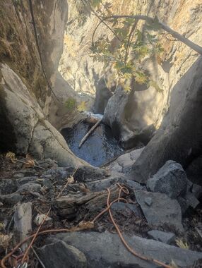
Bucks Creek has a really nice canyon section, kind of hard to get to. Located nicely if you want another great canyon to do with a Log Rides trip! Flow is dam released, constant and cold, at 12-13cfs, which is substantial and creates a likely dangerous hydraulic near the top. The water is a bit murky from activity at Bucks Lake, which makes any jumping hard to scout.
We explored this in August of 2025 as an overnight. Should be doable as a day trip, though some of the routes I'm suggesting are untested. Please update the page if you give it a try!
Approach[edit]
Bushwhack down through the burned area, finding the best route you can. Suggested route on GPX. (We started down the creek from just below the dam, and it was very tedious, not especially interesting, or recommended).
Descent[edit]
The first obstacle you come to is at the start of an obvious gorge. You can scramble down to the top of a ~5ft drop into a churning hydraulic. We used a log jam overhead to set a hand line to carefully climb/walk left around this. An anchor (would probably require bolts) on river left might be a more secure solution.
Lots of creek walking, interspersed with 3 rappels follow.
When you get to the main gorge, you'll know it. First rappel is a meat/anchor partner assist, or could be down from a tree to the pothole ledge/trees on the left. Then rappel down into the big chamber/pool. The next drop we downclimbed on logs.
For the next drop, there are ledges up to a few trees on the left. Climbing to the higher ledge up on the left requires a ~5.8 move but is easy to assist or spot. From there you can access the first potential tree anchor, but we climbed another ledge (~5.6) to the 2nd larger one for an easier rappel line that landed past the falls. (The lower ledge is slabbier, mossy, and very exposed, not recommended).
The next rappel we anchored off of boulders in a pothole ledge on the right.
Gorge opens slightly, then you climb back in to another rappel from river right into more gorge.
Next rappel down a very nice falls is anchored from a single bolt, just around the wall on river left.
Last rappel we anchored from a big rock chock on river right.
There's a nice camp not too far downstream.
Exit[edit]
Use the "Tobin Trail" to exit. We exited downstream (happening upon this trail that we didn't realize existed). While that's probably 10% easier, it requires a 1.5hr each way shuttle. The trail was maintained in 'okay' condition. Not great, much better than no trail at all.
Hiking up it seems like the best bet. You'll climb ~2800ft, but going down the trail still requires a lot of climbing and the stupid long shuttle. Although be warned, I have no idea what condition the upstream side of the trail is in!
