Bulldog Creek
| Rating: | |||||||||||||||||||||||||||||||
|---|---|---|---|---|---|---|---|---|---|---|---|---|---|---|---|---|---|---|---|---|---|---|---|---|---|---|---|---|---|---|---|
| | Raps:8, max ↨215ft
Red Tape:No permit required Shuttle:None Vehicle:High Clearance Rock type:Sandstone | ||||||||||||||||||||||||||||||
| Start: | |||||||||||||||||||||||||||||||
| Parking: | |||||||||||||||||||||||||||||||
| Condition Reports: | 29 Aug 2023
"R4 was anchored from a giant log in a log matrix. There was also a trad anchor on canyon left with a hammered-in fixed blade and two nuts that were al |
||||||||||||||||||||||||||||||
| Best season: | July-September
|
||||||||||||||||||||||||||||||
| Regions: | |||||||||||||||||||||||||||||||
Introduction[edit]
Located near Redstone, Colorado, Bulldog Creek is a small tributary to Avalanche creek. Historically, the area has been associated with the Avalanche mining district, now part of the White River National Forest. Although the creek exists entirely on National Forest land, the M & J claim along the creek is current. Avoid disturbing the old mining structures and tunnels or removing any minerals in the area.
This waterfall is a confirmed nesting site for the Black Swift, listed as a Species of Special Concern by the U.S. Forest Service and U.S. Fish and Wildlife Service. The swifts migrate from Brazil annually to occupy this site from late May until late September, raising a single chick. The swifts are susceptible to disturbance from human activities near their nests, including noise and movement, direct disturbance or destruction of their nests, and trampling of vegetation. Canyoneering/climbing at this waterfall during the Black Swift nesting season (late May - late September/first frost) is likely to cause direct damage to nests, eggs, and young, and disturb adult swifts enough to cause them to abandon their nest and offspring. Click here for more information on the Black Swift.
Approach[edit]
From Carbondale, drive south on highway 133 for about 12 miles until you reach Avalanche creek road. Drive about 1.7 miles till the road intersects Bulldog Creek at a water crossing. The trailhead starts just before the water crossing, on the north side of the road. Pull off parking can be found adjacent to the trailhead, as well as in a few spots in either direction on the road
On Foot:
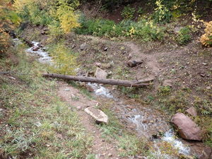
Depart Avalanche creek road, heading northeast. A well-defined trail follows closely to Bulldog Creek and eventually reaches an old abandoned mining structure. Past the mining structure, the trail crosses to the south side of the creek. A few social trails of varying quality exist heading north up the river. Take care to choose the most worn trail to avoid any additional excess erosion. The trail continues up the river until you reach an old abandoned mine. Soon after the mine you reach a waterfall, R8 of the canyon. This serves as a good spot to gauge the water before continuing the approach.
After viewing R8 just beyond the mine and at the junction of Bulldog Creek and an unnamed creek, which comes in from the right looking upstream, begin the approach by traveling upstream in the unnamed creek. Some small falls quickly block the ascent up the creek, but they can be easily bypassed on the south side. After bypassing the falls, continue up the creek for around another 1000 ft. You’ll pass an additional drainage which comes in from the right. A few hundred feet after, a faint trail to the left should appear, leading you to a large, abandoned mining structure. From here, make your way north towards Bulldog Creek. An outcropping by the creek serves as a vantage point for another large fall, R3.
Continue working up the ridges of the mountain, occasionally departing the ridge to contour the mountain closer to the creek. Alternatively, skip the two upper falls and enter the creek a bit upstream of the R3 lookout.
Descent[edit]
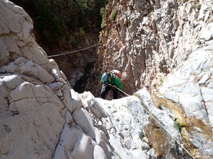
Enter Bulldog Creek just above R1. Please note that this canyon is frequented by ice climbers, and because of such, some of the anchors may not be suitable for all canyoneering rigging techniques. Leave any climbing hardware or pro as found.
- R1: 215’ from a tree DCL
- R2: 90’ from a tree DCR
Continue downstream through a lush, moss filled canyon. The creek eventually turns sharply left which indicates the arrival at the sequence of the next 3 rappels which come in quick succession.
- R3: 135’ from a tree DCR
Anchors in the R4 and R5 corridor are impacted by flash floods:
- R4: 100’ from a natural anchor to protect a 15' drop, 10' drop and a final ramp. Note an old piton and maybe some climbing nuts in a crack on Canyon Left that canyoneers have generally been choosing not to use. A deadman was used in 2021 (exploration). A log jam appeared and was used in 2023 (29Aug2023 conditions report).
- R5: 110’ or more for an 80’ waterfall from a natural anchor set back from the edge. A deadman was used in 2023 (29Aug2023 conditions report). A log just above the final ramp mentioned in R4 was used in 2022, making this longer. A log below the final ramp was used in 2021 (exploration).
The canyon narrows with steep walls on both sides. Continue downstream, downclimbing small obstacles along the way. The canyon will eventually turn sharply left when a giant tributary gully joins from Canyon Right where the next sequence of waterfalls occurs
- R6: 45’ from a tree DCR or downclimb
A small slide indicates the start of the final R7 & R8 sequence.
- R7: 150-200’ from a large tree higher on DCL just past the slide for a low ramp and two stages. Exploration beta described climbing out of the watercourse over a small dividing wall DCL, traversing a dirt gully and using another tree anchor DCL for a 70' rappel to reenter the watercourse above the R8 log anchor. The 29Aug2023 condition report called out this improved rappel anchor.
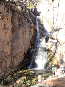
- R8: 160’ from a log pile DCR.
Exit[edit]
The last rappel finishes next to the trail. Follow the trail on the south side of the creek the same way you came in. Retrace the approach back to the trailhead.
Red tape[edit]
Beta sites[edit]
Trip reports and media[edit]
October 2 2021: First known summer descent by Ira Lewis, Andrew Tanasescu, Kati Wright, Eva Viatkus, AJ Pastula.


