Bulls Falls
| Rating: | ||||
|---|---|---|---|---|
|
| ||||
| | Difficulty:3 (v3) Raps:4-5, max ↨89ft
Red Tape: Shuttle: Vehicle:Passenger | |||
| Start: | ||||
| Parking: | ||||
| Condition Reports: | 16 Dec 2022
"DAY1. BULL CREEK FALLS. Party: Dad, Mum and I. At the end of my swing I picked up my van and found a quiet street close to the airport to |
|||
| Best season: | ||||
| Regions: | ||||

Introduction
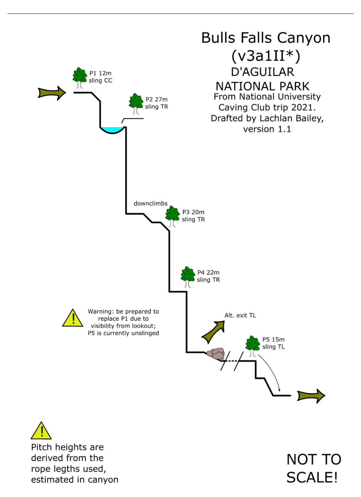
Located at Mt Mee in D'Aguilar National Park, this is a fun abseil trip in an open gorge type setting. A 4WD is not necessary. Start at the lookout, and on you go!
Approach
Most simple access is from Mount Mee via Sellin Rd to D'Aguilar National Park. Turn onto Neurum Ck Rd at The Gantry, parking at -27.086746, 152.697380 on Bulls Falls Rd, a short spur off Neurum Ck Rd. A car shuffle may be established by parking near where Neurum Ck Rd crosses the Bulls Falls creek (-27.073022, 152.702895), but this is not necessary. A short 500 m walk is required to access the falls from the second lookout encountered. Climb down to the left of the lookout to access P1, which is directly adjacent to the lookout. Note: there is a sealed road to The Gantry, and usually 2WD access to the carpark on Bulls Falls Rd. Neurum Ck Rd past Bulls Falls Rd is more unpredictable, and can be 4WD only.
Descent
P1 (12 m) – CC, sling around roots fig tree 6 m back from pitch. Be prepared to replace due to visibility for tourists. P2 (27 m) – TR, sling around small tree. P2 immediately follows P1, a rocky cascade with downclimbs to P3. P3 (20 m) – TR, sling around tree. P4 (22 m) – TR, sling around tree. Immediately following P3. Canyon degenerates into boulder pile and occasional creek walking to P4. P5 (15 m) – no current anchor, but plenty of options. Short, two-tiered semi-vertical waterfall. Easily bypassable on TL or TR. P5 is notably distant downstream of P4.
Exit
Bulls Creek is easily escapable at almost any point, and P1-P4 all appear to be bypassable by downclimbing on the TL. If a car shuffle was established, continue downstream from P4 along the Bulls Falls stream until Neurum Ck Rd is encountered, with the going easier after P5. Otherwise, the simplest exit is probably up the TL of the canyon immediately following P4.
Red tape
Beta sites
- https://canyoning.org.au/forum/viewtopic.php?t=110 - https://www.theverticaladventurer.com/single-post/the-ultimate-brisbane-canyoning-guide