Burnett Canyon
| Rating: | |||||||||||||||||||||||||||||||
|---|---|---|---|---|---|---|---|---|---|---|---|---|---|---|---|---|---|---|---|---|---|---|---|---|---|---|---|---|---|---|---|
| | Raps:2-7, max ↨160ft
Red Tape:No permit required Shuttle:Required 60 min Vehicle:Passenger | ||||||||||||||||||||||||||||||
| Start: | |||||||||||||||||||||||||||||||
| Parking: | |||||||||||||||||||||||||||||||
| Shuttle: | |||||||||||||||||||||||||||||||
| Condition Reports: | |||||||||||||||||||||||||||||||
| Best season: | Jun-Oct
|
||||||||||||||||||||||||||||||
| Regions: | |||||||||||||||||||||||||||||||
Introduction[edit]
Burnett Canyon is a small side tributary of the East Fork of the North Fork of the North Fork of the American River (EFNFNFAR), which itself eventually joins the NFNFAR just before the end of the technical section of Myo Canyon. Burnett contributes around 10% of the total flow of Myo at this point.
Before the EFNFNFAR confluence, Burnett Canyon is straightforward and has at least two gorgeous rappels, and there are two solid jumps/slides after joining EFNFNFAR. However, it suffers from the problems one might expect from this description. Namely, 1. The creek does not see enough water to prevent the growth of vegetation, so sections are quite brushy and 2. If flow conditions are challenging in Burnett, they are likely to be extremely difficult below the confluences.
Approach[edit]
Leave a shuttle vehicle at the Myo exit. Note that there have been perennial access issues with this parking. See Myo beta for details.
Drive in from Texas Hill Rd/NFH 19, past North Fork, Onion Valley, and Texas Hill campgrounds, turning right on FR 19-16 and right again on FR 19-16-01. At the next fork, either road works, but the left (south) fork is smoother and less steep. High clearance is helpful, but as of August 2025 the route is navigable for passenger cars. This network of forest roads also has several decent camp spots.
Park a vehicle at 39.23244, -120.66870, a large pullout on the left just before the road crosses the creek. From there, either bushwhack straight into the creek or walk the road to the bridge. Reach R1 after some brushy creeking. It’s likely also reasonable to skip the creeking (and R1) by parking near 39.23357, -120.67444, descending the ridge to 39.23171, -120.67971, and bushwhacking down to drop in near R2.
Descent[edit]
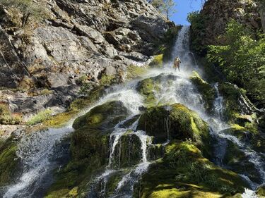
- R1: Upper Burnett Canyon Falls, 100' from tree DCR. The obvious plumb line DCR from the anchor is dry, but dropping into the creek DCL is also okay (and more fun). Take care with rope rub and routing for the pull if choosing this option.
A long section of brushy creekwalk follows. This could likely be avoided by dropping in near R2 as described above.
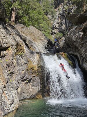
- R2: 50' from log center to first pool (recommended) then downclimb, or 90’ to second pool.
- R3: 20' from single bolt DCL or shallow jump
- R4: Lower Burnett Canyon Falls, 160' from single bolt DCR (or higher dry anchor from a tree high left)
- R5: 85' from logjam center. This seems likely to wash out in spring flows, but there are several other decent natural anchor options nearby.
At the base of R5 Burnett joins with EFNFNFAR, and flows increase substantially. Immediately following the confluence are several short downclimbs in the watercourse. In “fun” flows for Burnett, this section likely presents significant water hazard. After some downclimbs and:
- 12’ jump, or clean slide center (looks much bumpier than it is!),
- 15’ jump from boulder center, or careful slide DCL
(both bypassable),
EFNFNFAR joins with Myo after Myo’s R7, for another couple short jumps, downclimbs, or rappels before the Pool Of Cold Fire. This confluence again results in a substantial increase in flow and should not be underestimated in early season.
Exit[edit]
Follow the Myo exit. Creekwalk to the junction with the historical China Trail right where a dry-ish creek comes in at 39.231667, -120.692283 and take this 1300' up back to Lost Camp road and eventually the takeout vehicle. As you are standing at the bottom of the creek looking up it, you'll see where it immediately narrows and is up-climbable. However don't climb up these narrows -- the trail is just over to your left on the hillside as you're looking up at the narrows.
Red tape[edit]
There have been persistent access issues with Lost Camp Road and the takeout vehicle parking. See the Myo beta for the latest updates.

