Burrly Canyon
| Rating: | |||||||||||||||||||||||||||||||
|---|---|---|---|---|---|---|---|---|---|---|---|---|---|---|---|---|---|---|---|---|---|---|---|---|---|---|---|---|---|---|---|
|
| |||||||||||||||||||||||||||||||
| | Difficulty:3A III PG (v4a1 III) Raps:2-3+, max ↨80ft
Red Tape:No permit required Shuttle:None Vehicle:High Clearance Rock type:Sandstone | ||||||||||||||||||||||||||||||
| Start: | |||||||||||||||||||||||||||||||
| Parking: | |||||||||||||||||||||||||||||||
| Condition Reports: | 9 Nov 2024
"FUN. Big fun downclimbs, weird rocks, super interesting and pretty ridge exit. I like! One spot of water / mud near the end of the technical slot. The |
||||||||||||||||||||||||||||||
| Best season: | Fall to Spring
|
||||||||||||||||||||||||||||||
| Regions: | |||||||||||||||||||||||||||||||

Introduction
Down-climbing, down-climbing, and more down-climbing. Burrly Canyon has more down-climbing than most canyons I can think of, and includes an excellent 60-foot elevator-style down-climb. Skilled down-climbers can descend the canyon with as little as one rappel, while other groups may need to set up many more. Due to the difficulty and size of the downclimbs, this canyon should be considered R-rated. The canyon is scenic with views into Robbers Roost and the Dirty Devil River below. The exit is unusual, following a narrow and improbable peninsula, but requires either a fixed line set beforehand or 40 feet of climbing with a few 5.7 moves. If you are setting a fixed line, you will want to bring at least a 150-foot rope. The canyon is only a few miles from Burr Point and can be accessed with a high-clearance vehicle.
Approach
From the parking area, head directly west for about 10 minutes to reach the top of the drainage.
Descent
The canyon starts with a succession of three short down-climbs with short walks between each of them. The first rappel is after the third down-climb and offers many large boulders to be used as anchors. The rappel is about 30 feet long but the rope length will depend on your choice of anchor. On the RDC there is a ledge system that allows you to bypass the first rappel, though it is a bit exposed.

Directly after the first rappel, there is a 30-foot down-climb with a rabbit hole offering the easiest route down. This down-climb and most of the following down-climbs could easily be rigged as rappels. In this section of the canyon, escape is possible on the RDC if needed. After some squeezing or stemming, there is another 30-foot drop that can be rappelled or down-climbed with a tricky start. Soon after the down-climb, the canyon deepens and narrows with a 60-foot down-climb or rappel. You can’t see the bottom of the down-climb when starting it, but it is an excellent elevator-style down-climb. There are large chockstones at the top that would work well for rigging a handline or rappel. From the bottom of the drop, you can walk through the bottom to overlook the final sequence.


The final sequence of the canyon contains nearly 300 feet of down-climbing and one 80-foot rappel. It starts with a tricky 10-foot down-climb between large boulders, with the subsequent down-climbs being much easier. Continuous down-climbing eventually leads to a mandatory 80-foot rappel located under a refrigerator-sized chockstone. This rappel has a tight start and is somewhat tricky to rig. There are a number of smaller chockstones near your feet that can be used as anchors. It is a good idea to have the last person down take out any carabiner blocks due to the risk of getting them caught in the narrow canyon bottom. The rappel leads to a 15-foot rabbit hole down-climb between huge boulders. A shorter, less steep section of down-climbing marks the end of the canyon.


Exit
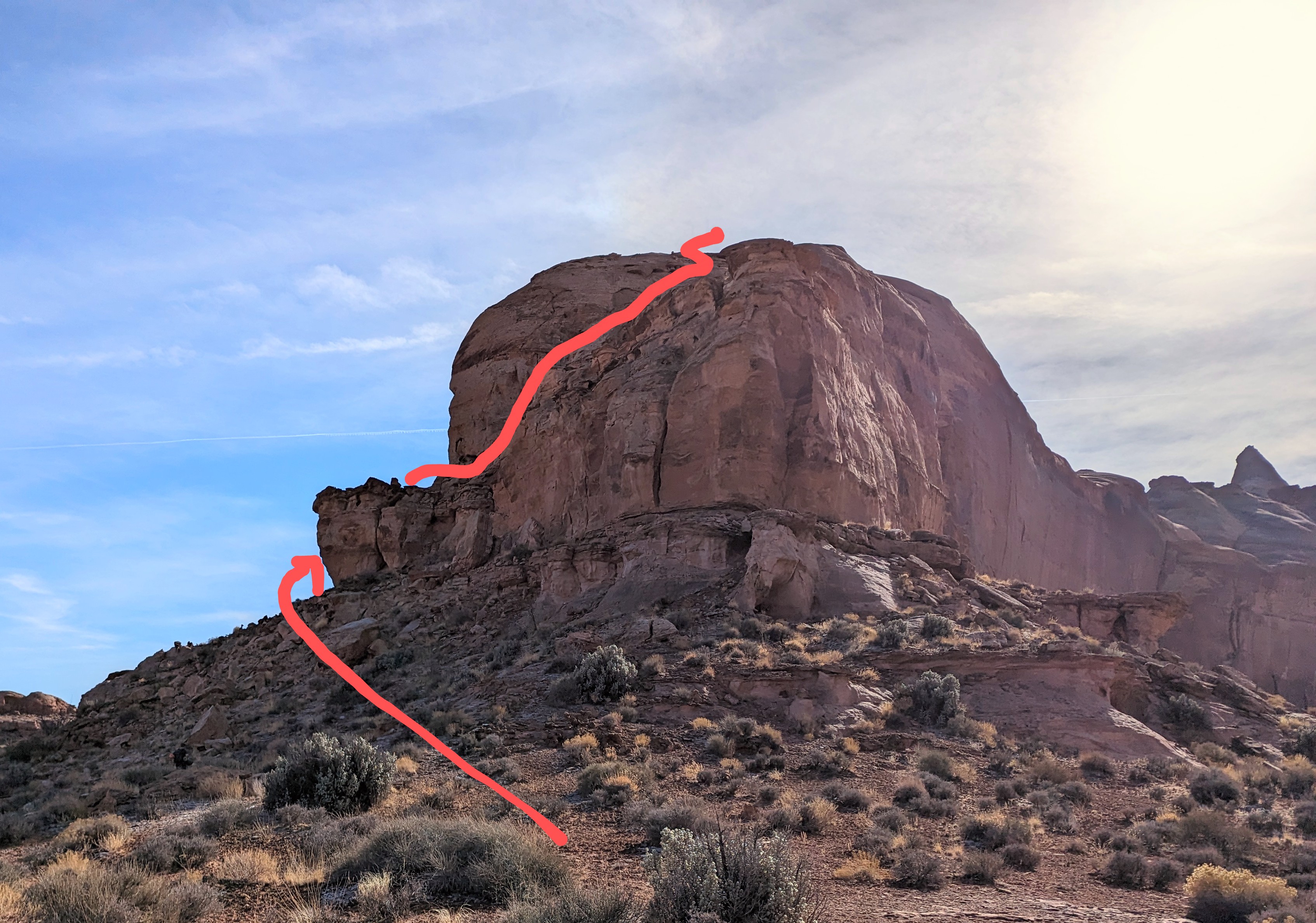
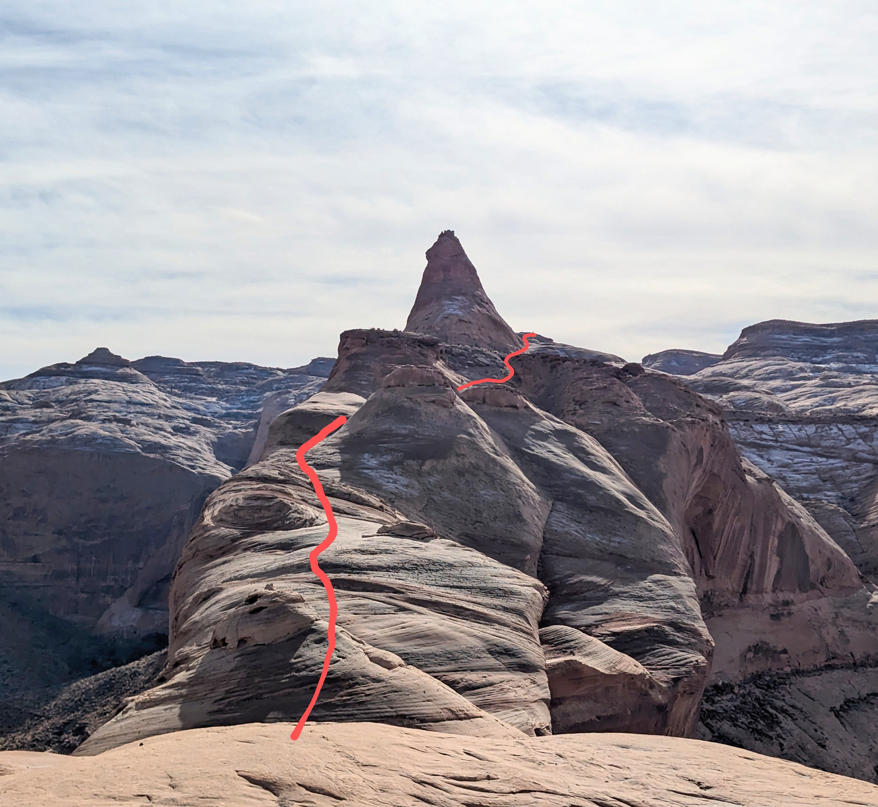
Head down the wash for 0.5 miles until you can start working up a hill to the tip of a peninsula directly east. When you arrive at the tip of the peninsula, continue on around the peninsula to the east for about 50 feet until you reach a rock ramp leading up onto the cliff above. The ramp should lead you back out to the tip of the peninsula and the start of the 5th class climbing section. If you fixed a line here before starting the canyon, this is where you will ascend about 40 feet. If you are climbing this section from the bottom, it goes at about 5.7. There are a few arches near the bottom that have been suggested as locations to sling for protection, but they are not very solid and not recommended. There is a crack half-way up that would take small cams. Climb up a short chimney and then exit the chimney with a stemming move out onto a face. Climb a second easier chimney that leads to low-angle scrambling. After reaching the top of the climbing section, look for a place to cross over to the ridge on the climbers left, and follow the ridge up the peninsula. There isn’t 5th class climbing from here on out (max about 3rd class if you take the easiest route) but parts of the exit would be dangerous or impossible if covered in snow. Follow the ridge until you are near the top of the mesa. Skirt along the western edge of the Swirly Canyon drainage until an exit is possible on your right near the very top of it. The parking area should be visible from here.

Red tape
Beta sites
Trip reports and media
The Exploration of Burrly Canyon
Background
Old webbing was found in two places near the start of the canyon, but there were no signs of webbing on rappels or drops in the rest of the canyon. Josh Allen partially descended this canyon in the Fall of 2023 but turned around due to not having intel on a good exit, or the final sequence. Austin Farnworth fully descended the canyon with a group in December of 2023 and decided to name it Burrly after its proximity to Burr Point and a burly 60-foot climb that Josh Allen was forced to do to escape the canyon during his descent.