Buttered Cat Canyon
| Rating: | |||||||||||||||||||||||||||||||
|---|---|---|---|---|---|---|---|---|---|---|---|---|---|---|---|---|---|---|---|---|---|---|---|---|---|---|---|---|---|---|---|
| | Difficulty:3A I (v3a1 I) Raps:5-7, max ↨65ft
Red Tape:No permit required Shuttle:None Vehicle:High Clearance Rock type:Sandstone | ||||||||||||||||||||||||||||||
| Start: | |||||||||||||||||||||||||||||||
| Parking: | |||||||||||||||||||||||||||||||
| Condition Reports: | |||||||||||||||||||||||||||||||
| Best season: | Spring or Autumn
|
||||||||||||||||||||||||||||||
| Regions: | |||||||||||||||||||||||||||||||
Introduction[edit]
Buttered Cat Canyon is a short canyon located near Naturita, a small town along the San Miguel river on the Western Slope of Colorado.
This canyon is situated on the Sawtooth Ridge in the Paradox Valley, named after the unusual crossing of the Dolores river across a gap in the valley's ridge rather than through the valley’s floor.
- Note: Culturally Sensitive Resources existing in the vicinity of this canyon. Please do not climb on, touch or otherwise disturb these resources. Cultural Resources in the vicinity are fragile and irreplaceable
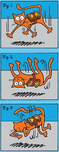
The Buttered Cat Paradox: Cats always land on their feet and buttered toast always lands buttered side down. The paradox arises when one considers what would happen if one attached a piece of buttered toast (butter side up) to the back of a falling cat.
Approach[edit]
Driving: From Naturita, drive west along SH 141. Continue till you reach a left turn onto SH 90 with signs for Paradox/Moab. Continue straight for about 5 miles until you reach a right hand turn onto EE22 Road, a graded dirt road. Continue down this road for approximately 3.5 miles until you reach a small pull off prior to the drainage of the canyon. Park here.
Hiking: Once parked, continue to walk down the path that forms at the pulloff. Do not walk down EE22 Road. Follow the old jeep road for a short distance till you reach the drainage that feeds into the canyon. Turn down the sandy wash and walk down canyon for a few short minutes until you reach the first rappel.
Descent[edit]
R1: (65') from a tree center canyon
DC: (10') The downclimb after R1 can be protected by rigging a 25' rope from a tree DCR if required.
A short downclimb leads to a small fork in the canyon.
R2: (40') from a set of bolts DCL. The bottom of this rappel may have unavoidable water. Downclimb on DCR to skip the rappel and avoid the water.
After R2, the canyon forms a short sculpted narrows section with 3 rappels. The waterline on the canyon wall’s suggest that this area could hold water after significant rain.
R3: (40') from a set of bolts DCL
R4: (55') from a set of bolts DCL down a narrow chute
R5: (45') from a set of bolts DCL
A final (10') downclimb on DCR could be rigged with a short rope as a handline from a bolt on DCR
Exit[edit]
Continue descending down canyon, downclimbing a few small drops as needed until the exit trail appears DCL, stopping short of the point at which the canyon opens up completely. Proceed up the ramp DCL, gaining the ridge above. Pay extra attention to the loose rocks and numerous cacti which are present on the exit scramble. Once above the ridge, the trail flattens and a direct, sandy path leads back to the vehicle parking.
Red tape[edit]
Beta sites[edit]
Trip reports and media[edit]
5 April 2024: Descended and beta added to ropewiki; Ira Lewis, Andrew Tanasescu, Kati Wright, Wayne Herrick, Rob Demis, Deanpaul Russell, Carl Bern, Dan Kinler, Marlene Swift


