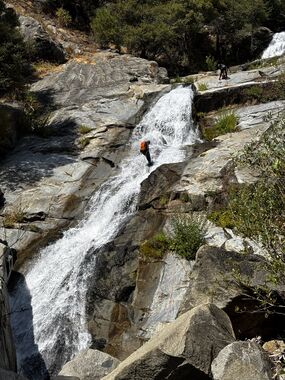
Camp Creek (Plumas National Forest)
| Rating: | |||||||||||||||||||||||||||||||
|---|---|---|---|---|---|---|---|---|---|---|---|---|---|---|---|---|---|---|---|---|---|---|---|---|---|---|---|---|---|---|---|
| | Raps:8, max ↨150ft
Red Tape: Shuttle:Optional Vehicle:Passenger | ||||||||||||||||||||||||||||||
| Start: | |||||||||||||||||||||||||||||||
| Parking: | |||||||||||||||||||||||||||||||
| Condition Reports: | 28 Sep 2025
"Better than expected first descent!. We bolted the 2 big drops, but everything else can be done with natural anchors. I wore a 3mm wetsuit and was |
||||||||||||||||||||||||||||||
| Best season: | July-October
|
||||||||||||||||||||||||||||||
| Regions: | |||||||||||||||||||||||||||||||
Introduction[edit]
A nice jaunt of a canyon when you’re in the area for something bigger and more impressive, and you want an easy second day.
The middle section (just above the bridge) meanders through the shade and features a handful of short rappels with easy natural anchors. The lower section (from the bridge to the power station) has two long bolted rappels, and a bit of down-climbing and boulder hopping, before it lets you out next to a power station.
Note, there is an upper section, but the quality is not high.
Approach[edit]
If you have a higher-clearance vehicle, you can likely shuttle this canyon. When it was first descended in September, 2025, there was a rock on the road our small SUVs (Honda CRV sized) could not pass, but that would be easily overcome with a larger vehicle.
You can check the flow as you cross the bridge, both visually and by scrambling down to read the actual gauge under the bridge. If you’re thinking about climbing the pensock pipe to exit, be sure to check the condition of the fixed line from the top here, as well!
No shuttle: park as close to the bridge as possible, then walk along the road to the drop-in point.
Shuttle: set an exit vehicle as close to the power station as possible (the road is gated, so you may not be able to drive all the way down). Drive to the drop-in point.
From the drop-in point, make your way down the hillside to the creek and suit up.
Descent[edit]
Middle section:
- R1: 20’ RDC from a tree
- R2: 40’ LDC from a tree
- Down climb (or R2.5) 30’ RDC to the top of a small dam (you will need 50’ of rope if rappelling)
- R3: Downclimb RDC to a 30’ drop off of a tree
- R4: 30’ LDC from a pinch point between two rocks. This drop can be downclimbed by strong climbers, with a partner assist at the end.
Cross under the bridge to the lower section:
- R5: Downclimb to a 40’ drop from tree roots
- R6: 100’ single bolt in center
- R7: 150’ single bolt LDC
- R8: 20’ RDC from a tree
Exit[edit]
Choose your own adventure for the exit: hike back up the road to your car, or scramble/hand-line/quasi ascend the fixed line attached to the 1000-foot penstock pipe (be sure to check the condition of the line before choosing this option!).
Red tape[edit]
Beta sites[edit]
Trip reports and media[edit]
Background[edit]
First known descent: September 28, 2025, by Hill Belfi, Steve Ching, Seth Kirby, Kelly Morr, and Austin Wilkins. Discovered by Joseph Tomasi.


