Campo Pozino
Jump to navigation
Jump to search
Also known as: Barranco Campo Pozino; Moros.
| Rating: | |||||||||||||||||||||||||||||||
|---|---|---|---|---|---|---|---|---|---|---|---|---|---|---|---|---|---|---|---|---|---|---|---|---|---|---|---|---|---|---|---|
|
| |||||||||||||||||||||||||||||||
| | Raps:max ↨49ft
Red Tape: Shuttle:None Rock type:Flysch | ||||||||||||||||||||||||||||||
| Location: | |||||||||||||||||||||||||||||||
| Condition Reports: | |||||||||||||||||||||||||||||||
| Best season: | Anytime;HOT in Summer
|
||||||||||||||||||||||||||||||
| Regions: | |||||||||||||||||||||||||||||||

GPS data automatically extracted from descente-canyon.com, please visit their site for more detailed information.
Introduction
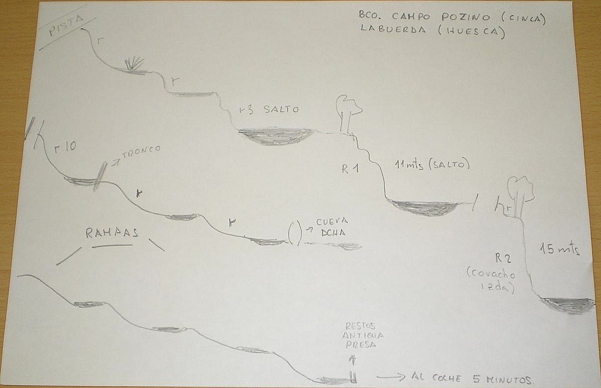
Acceso desde: LABUERDA
Altura de rápel mas largo: 15 mts
Material necesario: 2 x 30
Neopreno: SI
Material de instalación: Aconsejable llevar material de instalación de repuesto
Epoca: Todo el año, aunque el verano no será el mejor momento
Observaciones: pequeña cavidad, en el comienzo de las rampas
Horario de aproximación: 30 minutos
Horario de descenso: 1hora y 15 minutos
Horario de retorno: 5 minutos
Mapa: AINSA-SOBRARBE (PRAMES) 1:40.000
Cuenca: Río Cinca
Coord. GPS del inicio: 31T 0264813 4706764
Coord. GPS del final: 31T 0265359 4706212
Altura en inicio: 708 mts
Altura en final: 588 mts
Desnivel: 120 m
Carácter: ABIERTO
Tipo de roca: FLYSCH
Approach
Desde Ainsa, dirección Labuerda, 2km después a la altura de la subestación electrica de Escalona, ahi esta el final del barranco. Parking, en el mismo barranco. Subiremos por pista, con cadena, hasta cruzar una cantera, desde aqui la pista desciende hasta cruzar el barranco. Punto de entrada
Descent
Abierto con un tramo de grandes marmitas con algun salto y un rapel, pero con espacios sin interes entre ellas y unas rampas finales bonitas.
Escapes: SI,
Exit
Evidente.
Red tape
Beta sites
 Descente-Canyon.com : Campo Pozino
 Barranquismo.net : Campo Pozino
- Wiki-Infobarrancos : Barranco de Campo Pozino (http://infobarrancos.es/)