Canyon Creek (Opho)
| Rating: | |||||||||||||||||||||||||||||||
|---|---|---|---|---|---|---|---|---|---|---|---|---|---|---|---|---|---|---|---|---|---|---|---|---|---|---|---|---|---|---|---|
| | Raps:20, max ↨160ft
Red Tape:No permit required Shuttle:None Vehicle:Passenger Rock type:marble | ||||||||||||||||||||||||||||||
| Start: | |||||||||||||||||||||||||||||||
| Parking: | |||||||||||||||||||||||||||||||
| Condition Reports: | 29 Sep 2025
"All bolt stations found except rappel 5 or 6. Found relatively new sling/ring around pinched boulders dcr and slightly higher.. Skipped rap 2 or 3 |
||||||||||||||||||||||||||||||
| Best season: | Jul-Oct
|
||||||||||||||||||||||||||||||
| Regions: | |||||||||||||||||||||||||||||||
Introduction[edit]
Update 29 Oct 2022: All of the required bolt stations for the upper section have been repaired / replaced.
Sections of this land were bought by new owners as of March 2015, and some of the access points may now be considered trespassing. In particular the road to the mining tunnels are marked as private property.
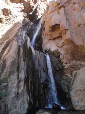
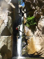
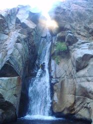
This is an amazing canyon, one of the best in the region. To access it, you have the option of rappelling down a mine! The canyon is well sculpted and very aquatic, very similar in nature to canyons in the Alps but with darker water. It gets very narrow so at high flow can be dangerous for inexperienced canyoneers. The canyon is very technical, with quick successions of wet rappels one after the other all the way to the North Fork of the American River.
The best water flow checkpoint is the first rappel. If you see some insane water flow coming down this rappel, abort the descent. It just gets worse downstream.
Approach[edit]
Take I-80 west of Truckee, then Magra road (parallel to I-80) then take Garrett road 1.5 miles to a dirt turnout on the left, where a large tree grows right next to the road. Follow the dirt road to the left a short distance to a clearing, and park there. The parking area coords are 39.1565, -120.8527. There is room for several cars and tents, but no facilities. The short stretch of dirt road may be difficult for vehicles without high ground clearance, but it is a short walk in any case and it may be possible to park elsewhere nearby. This trailhead is in the middle of a neighborhood with houses in the vicinity. Please keep noise to a minimum as to not do anything to impact access to this canyon. Try to park your vehicle(s) out of view of Garrett Road. Do not leave any trash in the vicinity and pick up any that you see. No fires allowed.
Several trails start at the parking area. From where the road enters the parking area, the correct trail is ahead and down the hill to the left. Follow the sometimes faint trail and go downhill along the path until you get to dirt road. Continue east to northeast along the road following the track on the map. At one point as the road switches back to the left at the bottom of a ravine, look to your right and you will see a short tunnel. (For a diversion through the short tunnel, see Cabin Route below) Continue following the road. After about another quarter of a mile you will come to an intersection with a road to the right. From here you have two options: Continuing along the road takes you to the Mine entrances. Turning right takes you on another road and along trails to the drop in point, and avoids the mine tunnels.
Road + Trails Approach: Turn right and follow the loop road as it winds through trees and climbs slowly toward a low ridge. After about a half mile, and nearing the ridge top, turn right on what was an old wagon old road, but now quickly closes in and becomes a trail. Cross up and over the low ridge and continue down as the trail steepens. You will cross an intersection with the Indiana Hill Ditch trail and continue downhill. You will come to a T junction with the Canyon Creek Trail and turn right. After a hundred yards or so, there will be a short spur trail to the left that takes you to the mine tunnel exit. The tunnel exit is interesting, and you might take a short detour to explore it. Otherwise continue down the Canyon Creek Trail until you reach the creek. This approach is the fastest and easiest way to get to the main descent of Canyon creek.
Mine entrance: Continuing along the road walk past a pond on your left. After this is a large open gravel area, and on the far side of it the road is washed out over a dry gully heading to the right. When you reach the drainage drop down and to the right that will take you to the point named Tunnel1 at the opening of the mine. You will have to rappel down into it about 40'. After the rappel and a short easy downclimb, the tunnel is straight, large, and easy to walk, though wet and muddy. Your feet will get wet and you will need headlamps to traverse it. Watch out for snakes in this tunnel, several different kinds including rattlesnakes have been encountered in here. Follow the tunnel straight ahead until you get to a T-intersection after several minutes. Take a left at the intersection (if you take a right, you end up at the point named Tunnel2; this can be used as an exit or alternate entrance, see below). Soon, you will see daylight again, at the point named Tunnel3. Once you exit the tunnel take a trail on the right that borders the river and go downstream for 15 minutes till you reach a tiny wooden bridge.
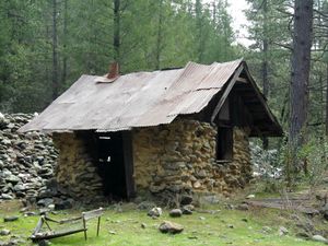
Cabin Route: This is a diversion/option on the Road + Trails approach. On this route you will see a degraded mining cabin and do a little cross country travel. At the switchback on the main approach road described above, turn south and pass through the short tunnel through a conglomerate ridge. Moderate earthquakes in Truckee in 2021 caused material from the roof on the south end of the tunnel to collapse, and make exiting the tunnel a little tricky. Shortly after exiting the tunnel, turn right on an obvious trail. After about 100 yards, there will be a spur trail to the left that crosses an intermittent creek. The spur trail quickly takes you to an old mining cabin. This cabin was restored by the BLM some years ago, but not long after restoration, a dead tree fell on the cabin. The cabin remains crushed. Either return to the main road and continue either of the approaches described above, or for a more challenging route, walk to the top of the boulder pile behind the cabin. Continue along the ridge of boulders to the left and through some trees and you will come to a break in the conglomerate cliffs. The poison oak is particularly thick in this section. Climbing the break in the cliffs is class 4, but loose cobbles can make it challenging. At the top of the conglomerate cliff, take a hard left and follow a trail through trees and manzanita for 100 feet until you come to a T intersection with an old road. Turn left on the road, and after about a quarter of a mile you will come to another T intersection with a more developed gravel road. This road is the approach road described above in the Road + Trails approach. Turn right to follow that approach.
Descent[edit]
This is not a beginner canyon. The descent is challenging from the start to the end, with most rappels right in the middle of the water flow with little or no option to escape pummeling under heavy flow. There is an escape in the middle of the canyon, after 11 rappels that culminate with a multistage big drop. After that there are 9 more rappels to reach the American River, but few people do the last 2, which can be walked around DCR to reach the river.
This canyon used to be set up all with natural anchors that would require 200' of fresh webbing every year. Over 2013 and 2014, a number of rappels have been bolted, but many of the rappels still require building natural anchors and many bolts are currently singletons. Be prepared and bring webbing.
The longest rappel is 160' at the big waterfall. In the past a ledge halfway down had bolts to set up a second rappel (limiting the longest rappel to 110') but recent groups have found these missing. Ropes frequently get stuck on the pull from rocks in the hanging pool, so it is advised to throw the pull rope over the ridge DCR for a dry pull keeping the rope from falling into the hanging pool.
Exit[edit]
The last 2 rappels to the North Fork of the American River are optional, but definitely worth doing if you still have energy. The last section of the canyon also has several fun downclimbs, and NF American River is a very beautiful spot to get out of the wet suits and relax for a while if you have time. The return involves hiking back following a faint trail over on canyon left. There can be a plethora of Poison Oak along much of the trail on both sides; you have been warned. Switch backs will take you up cliffs but not too bad. You will travel along the side of the canyon looking down into the waterfalls you just rappelled. There are several intersections, where the early exit trails from the canyon joins your trail. Always keep up and to the right. Eventually the trail will take you back to the washed out bridge where you started and back to the Tunnel you originally exited from. From here you have three options:
- Through the Tunnel: Go into the Tunnel and proceed upstream, then continue straight at the T-intersection. There is some mud and a climb up a nice aluminum extension ladder (formerly a very sketchy climb on a half-broken rusted ladder, which is also still there), followed by a climb up a loose, sandy gully. This point is marked Tunnel2 on the map. It will help if first person out ties a rope to the big tree at the top of the shaft to assist the others (as of August 2015, there was a 3/4 inch or so thick laid nylon fixed rope there, maybe left by the same person who put the extension ladder). In fact, if you want to use this exit, you may want to fix a rope from the tree on the approach, and pick it up on your way out. From the top of the shaft go right to reach the gravel area where the pond was. From there walk back the trail you did for the approach.
- Roads and trails: Reverse the route described in the "Roads + trails entrance" section of the Approach above. This is the easiest and fastest way to return to your vehicle.
- Indiana Hill Ditch Trail: if you have the energy and daylight for a more scenic exit, reverse the Roads and Trails approach until you come to the trail intersection on the map marked Junction Indiana Hill Ditch Trail. Turn left and follow a narrow but mostly level trail out for some nice views of the North Fork American River canyon. After about a half mile, start looking for an obvious break and trail through the ridge to the right. If you come to a conglomerate cliff, or start going downhill, stop and go back to find the correct route. After turning right, pass into an opening in the trees and continue to the right on an old road. You will pass the junction with the Cabin Route diversion described in the approach, but that route is better done as an approach because the junction might not be obvious, climbing down the conglomerate cliff with its loose cobbles is definitely more challenging than climbing up, and route finding is not as obvious in the reverse direction, especially if your daylight is fading. Continue along the old road until you come to a intersection with a more developed road and turn left. You are now back on the Roads and Trails route, and you can reverse the route to your cars.
Note that it is also possible to take either of the three exit routes as the approach trail, but the rappel into the mine is more fun, and considered part of the Opho route.
Red tape[edit]
Sections of this land were bought by new owners as of March 2015, and some of the access points may now be considered trespassing. In particular the road to the mining tunnels are marked as private property. A group rappelled through the mine entrance on August 8th, 2015, and came out at the creek to find the new owners who expressed that they weren't open to canyoneering on their property for liability reasons. The extent of ownership and current ownership information hasn't been reconfirmed since this original discussion.
Beta sites[edit]
Trip reports and media[edit]
- http://vimeo.com/106352715
 Joe Bugden on Canyon Tales : Ophidiophobia - June 8, 2005
- Facebook Album 2010
- Facebook Album Sep 2014
- various info about the trail, other posts on the same site also describe other aspects of Canyon Creek. Russell Towle seems to have been an expert on the North Fork of the American, but died in a car accident in 2008 :( LOTS of good info there though.
Background[edit]
Rumor has it that "Stevie B" did the first descent between 2000-2003, the precise circumstances are unknown. It is sometimes also referred to as "Snakepit".
First decent may have been had by Brendon McKeon & myself. i first met Russell Towle ( (legendary N fork American River explorer & preservationist) in 2000 in the parking lot of Mountain Springs Hitch n Post in Gold Run, CA. He gave me beta on how to enter Canyon Creek from Garrett rd, traversing East across private Mine property. I told him my intentions of rappelling the canyon, he had heard of no-one descending thru the waterfalls in his 15-20 yers of deep canyon investigation. He asked to come on our adventure & gave me his phone #. (story to be continued) - Wildernessgoat, Misha Meng (PS- Stevie B, I am looking forward to speaking w you)


