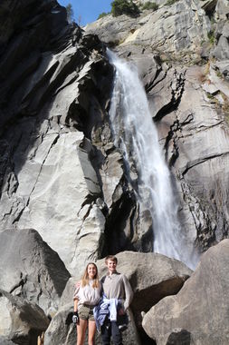
Cascade Creek (Yosemite National Park)
| Rating: | |||||||||||||||||||||||||||||||
|---|---|---|---|---|---|---|---|---|---|---|---|---|---|---|---|---|---|---|---|---|---|---|---|---|---|---|---|---|---|---|---|
| | Raps:6, max ↨280ft
Red Tape:No permit required Shuttle:Optional 10 min Vehicle:Passenger Rock type:Granite | ||||||||||||||||||||||||||||||
| Location: | |||||||||||||||||||||||||||||||
| Condition Reports: | 19 Sep 2022
"Finally, I did a proper run of Cascade Creek all the way down following the water course. Installing the needed bolts was definitely "special challen |
||||||||||||||||||||||||||||||
| Best season: | All Year, extreme flow in spring
|
||||||||||||||||||||||||||||||
| Regions: | |||||||||||||||||||||||||||||||
Introduction[edit]
Cascade Creek is one of several Creeks feeding the Merced River on the way into Yosemite Valley, and offers a very short sneak route with a shuttle (shown on map). Also, there is a much longer route with or without shuttle (also shown on map). As well, Tamerak Creek is another option doing the longer approach and it has much less flow Cascade Creek, thus offering possible runs in spring when Cascade Creek flow is extreme.
Approach[edit]
For the Sneak and Shuttle route park one vehicle at the lower parking area 37.723877, -119.712287 (El Portal Road / Hwy 140), drive to the middle parking area 37.727539, -119.712672 (on Big Oak Flat Road / goes to Hwy 120), and hike directly under the bridge adjacent to the middle parking area.
Descent[edit]
There are many trees, big rocks and plenty of width to Cascade Creek to establish anchors almost anywhere to descend the drops. Depending on where each drop is rigged, the drop lengths and water hazards will vary dramatically. It’s certainly possible to run the creek staying dry, or be totally hammered by huge water flow.
For the sneak and shuttle run of the lower creek in low to moderate flow:
R-bonus 40' off the Hwy 120 bridge, or just hike down the steep slope DCL side.
R0 30-50' anchor off various trees or rocks to get down waterfall just downstream of the bridge, or hike down a use trail DCR.
R1 90' ghost off a large tree on an easy accessible shelf DCL, down the water course ramp with a rope (and Fiddlestick) eating crack
R2 ~80' pinch point and jammed log, over the rounded ledge straight into the waterfall!
R3 ~100' rock horn behind a bush about 50 left of R2 touchdown, down several ledges, vertical to a sizeable ledge with waterflow. If you rappel to the huge sloping ledge further down (~150 feet) you miss the R4 bolts that align you with the R5 bolts, and you will have to work down slimy rock slab and waterflow to get to the R5 bolts. Alternatively, you can cross over the waterflow on the huge slab and use the last bolted anchor for Tamarack Creek which is totally out of the water flow
R4 ~100' bolts far DCL side of the sizeable ledge.
R5 280/130' traverse DCL to bolts on flat ledge. 280' to the pool at the bottom, or 130' to small ledge behind a huge flake.
R6 150' from the bolts behind the flake which may be in heavy spray to powerful waterflow.
From the terminal pool stay far DCL on the boulders to a light trail.
Exit[edit]
From the bottom of the big drop stay left, find an old platform and the trail leading to it. This old trail bends left (East) goes past some old water infrastructure, then makes a sharp bend back right (West) and heads down to the road. It's a short hike along the road to the lower parking lot.
Alternately, since the sneak route is so short, rigging fixed lines down and ascending back up will work nicely provided the ascending ropes are not rigged in heavy water flow. This would avoid needing the car shuttle.
Red tape[edit]
Beta sites[edit]
Trip reports and media[edit]
Background[edit]
Given the old platform and defunct exit trail, Cascade Creek Falls must have been a significant Yosemite attraction many years back. It’s since become obscure, but it still well visited by people who know about it. Even if you do not run the technical section, just hiking up the exit trail (or the boulder field) offers an amazing view of the final waterfall.
