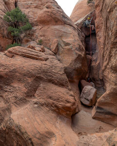
Catch 22 Canyon
| Rating: | |||||||||||||||||||||||||||||||
|---|---|---|---|---|---|---|---|---|---|---|---|---|---|---|---|---|---|---|---|---|---|---|---|---|---|---|---|---|---|---|---|
| | Difficulty:3A I (v3a1 III) Raps:5, max ↨70ft
Red Tape:No permit required Shuttle:None Vehicle:High Clearance Rock type:Sandstone | ||||||||||||||||||||||||||||||
| Start: | |||||||||||||||||||||||||||||||
| Parking: | |||||||||||||||||||||||||||||||
| Condition Reports: | |||||||||||||||||||||||||||||||
| Best season: | Spring or Autumn
|
||||||||||||||||||||||||||||||
| Regions: | |||||||||||||||||||||||||||||||
Introduction[edit]
Catch 22 Canyon is a short canyon located near Naturita, a small town along the San Miguel river on the Western Slope of Colorado.
This canyon is situated on the Sawtooth Ridge in the Paradox Valley, named after the unusual crossing of the Dolores river across a gap in the valley's ridge rather than through the valley’s floor.
Approach[edit]
Driving: From Naturita, drive west along SH 141. Continue till you reach a left turn onto SH 90 with signs for Paradox/Moab. Continue straight for about 5 miles until you reach a right hand turn onto EE22 Road, a graded dirt road. Continue down this road for approximately 2 miles until you reach a small pull off prior to the drainage of the canyon. Park here.
Hiking: Once parked, continue to walk down the road for a short distance till you reach the drainage that feeds into the canyon. Turn down the sandy wash and walk down canyon for a few short minutes until you reach the first rappel.
Descent[edit]
R1: (25’) from a single bolt DCL
R2: (65’) from a set of bolts DCL
R3: (35’) from a tree DCL
R4: (70’) from a set of bolts DCL down a narrow chute under a small boulder cave
Optional Exit: Head up the fault on Canyon Left after R4 to cut some of the elevation out of the exit hike
R5: (65') from a tree DCL down a low angle chute. Or easily bypassed DCR
Exit[edit]
Shortly after the last rappel rappel, beginning climbing on the hillside DCL, gaining the ridge above. Pay extra attention to the loose rocks and numerous cacti which are present on the exit scramble. Once above the ridge, the trail flattens and a direct, sandy path leads back to the vehicle parking.
Red tape[edit]
Beta sites[edit]
Trip reports and media[edit]
5April2024: Descended and beta added to ropewiki; Ira Lewis, Andrew Tanasescu, Kati Wright, Wayne Herrick, Rob Demis, Deanpaul Russell, Carl Bern, Dan Kinler


