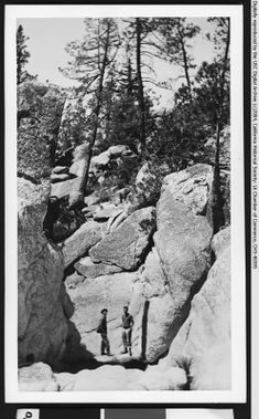
Chilao Creek
| Rating: | ||||||||||||
|---|---|---|---|---|---|---|---|---|---|---|---|---|
| | Difficulty:2A IV (v1a1 IV) Raps:0, max ↨0ft
Red Tape: Shuttle: | |||||||||||
| Location: | ||||||||||||
| Condition Reports: | ||||||||||||
| Best season: | ||||||||||||
| Regions: | ||||||||||||
Introduction[edit]
Snazzy drier route in the San Gabriel Mountains. A lot of history. A ton of bouldering and use of rock climbing moves. If you have to rappel even once,there is not enough time for the full wilderness route. Sticky shoes and bring your own water essential. Dont come here in a storm as the visibility could be 25ft. Best late October through May.
Approach[edit]
Early start. Drive or walk to day use parking area @ intersection of Chilao road & Silver Mocassin trail. Then walk along paved road to Manzanita Loop campground or farther.
Descent[edit]
First, descend lower Chilao Creek: 6 short obstacles(from Meadows start) that should be bypassed/not rappelled. (Exit#1: Ascend East Fork Alder to Silver Moccasin trail...note: this is a route design and not easy peasy, with 3 obstacles of its own.) Second, descend East Fork Alder Creek: 5 short obstacles that can be bypassed. The third is a scramble down the watercourse....the others canyon left. The section of the creek between the 4th and 5th obstacle is a slog, but not terrible. Exit#2(main exit): @ 5th obstacle, a short drop into a pool. Hike up canyon left to peak 4224 ridge and then up and southbound to the southwest/natural end to the Silver Moccasin trail. Thirdly, descend Alder Creek to elevation 3700 Finally, return to Exit#2 since further travel is prohibited and its completely overgrown downstream of Mule Creek
Some variations make sense too. Such as an easier route descending East Fork Alder. Or descending Exit#2 to do the end of the route on a separate occasion.
Conditioning/skills: This is not a dare: 'Wilderness', meaning if you treat this route like Runyon or Little Santa Anita, you or your group WILL fail to adapt....even with a beacon, it will amount to a difficult rescue based on the large area needed for this beta....so dont come near Exit#1 if something is amiss time-wise, injury-wise or whatever-wise. Consider the terrain after obstacle #5 to be a point of no return with the ability to exit.
Weight: Its a question of how much weight you want to carry up and down boulders over and over again. Whereas a heavier backpack for a longer route might be normal in the San Gabriels, in this locale its making the situation worse once you are carrying above a certain weight. For example, doing a full dip strength exercise with 50 lbs around your waist vs 20 lbs.
Exit[edit]
Silver Moccasin trail. If returning via exit#2, stay right at a fork. Going left and lower on a paved road takes you to East Fork Alder. Exit#2 has very little shade for most of it. Silver Moccasin even less shade. Water source is zero.
Red tape[edit]
Organized camping inside Chilao is a 11am checkout time and costs about $12 for one day. There is a caretaker along the road, between Little Pines campground and Manzanita campground that is open for emergencies in case someone is injured and the area is not closed for the winter.
Beta sites[edit]
Trip reports and media[edit]
Background[edit]
The beginning of this route along lower Chilao creek is named Sandy Bottom Boulders, more specifically for the bottom of obstacle#2.
