Chino Canyon (Left Fork)
| Rating: | |||||||||||||||||||||||||||||||
|---|---|---|---|---|---|---|---|---|---|---|---|---|---|---|---|---|---|---|---|---|---|---|---|---|---|---|---|---|---|---|---|
| | Difficulty:3B III (v3a2 I) Raps:1-4, max ↨150ft
Red Tape:No permit required Shuttle:None Vehicle:Passenger Rock type:Granite | ||||||||||||||||||||||||||||||
| Location: | |||||||||||||||||||||||||||||||
| Condition Reports: | |||||||||||||||||||||||||||||||
| Best season: | Late fall, before first snow. Late spring.
|
||||||||||||||||||||||||||||||
| Regions: | |||||||||||||||||||||||||||||||
Introduction[edit]
Gauzed upon by many tourists, this canyon is certainly an adventure, although most of the difficulty is created by the Tramway. Heavy brush, poison oak and grape vines in the lower half of the canyon detract from an otherwise standard Socal Canyon. While not technically illegal, the Tramway security really doesn't like people up in the canyon past the lower Tram station, similar to the nearby Falls Creek Canyon. See here
Approach[edit]
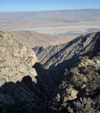
Park at the Tramway, $8 as of Dec 2017. Ride up the Tram. Check the website for operating hours and cost of tickets. Off season (winter) the first car up is 1000. Hike over to Grubbs Notch and start descending on the Skyline Trail at 33.811791, -116.637130. Hike down the Skyline trail to a large boulder at 33.8129986, -116.241139, at 6650 ft. Look down for some bare patches of dirt to the north, on the canyon rim. This is where we dropped in. Head through the chaparral to the rim at 33.8168508, -116.6229897, 6300 ft. This is a good place to scout the canyon.
Descent[edit]
We chose to wrap a boulder and rap in at 33.8171512, -116.6222266, a 75 ft rappel to tree in a chute.
We then rappelled 150 ft to 3rd class terrain. Several other approaches are possible, including a loose, dirty 4th class downclimb near where we rappelled in; I wouldn't recommend trying it. Whatever you do, watch out for falling rocks. Several large boulders are precariously balanced. Wherever you feel comfortable, pack the ropes. You may want to keep a short hand line handy. Hike down canyon for an hour or so.
At about 33.822746, -116.618271, 4400 ft, the real business starts. Thick vines impede progress, ensnaring your whole body.
They cover the boulders, hiding holes large enough for your entire body to fall into when you inevitably break through. Progress will be slow, plan on about a quarter mile in a hour. Gloves, pants, a long sleeve shirt, safety glasses, and a helmet are highly recommended. A hand line may be used to help down climb some boulders. Year round water will be tricking along the bottom. When you finally break through to the obvious 100 ft rap down a small water fall at 33.8304772, -116.6183142, 3100 ft, you are almost out. Use a tree anchor, and if you are leaving webbing, use a natural color, as it is visible from the Tramway.
Exit[edit]
Proceed down the canyon, to where it intersects the main canyon, with staying well clear of all Tramway property. It would be prudent to follow the contour DCR at about 3000 ft, and when you are above the parking lot, descend to your car.
Red tape[edit]
I’m not a lawyer, nor do I play one on TV. From what we can tell, as long as you stay off of tramway structures (this includes the paved road under the tram) you will not be able to be charged with trespassing, as the land around is public property. Be prepared to be detained. If security sees you, you will be escorted down. It is unknown where or what the exact line or rule is, as tramway personnel are not forth coming with information, aside from “stay away from the towers”. If anyone has additional information, I'd love to hear it. I’m posting anonymously, not uploading the my GPS track, and posting a select few pictures due to the above issues.
In theory, one could wait at the top of the last rappel until just before dark, out of sight of the tram, rappel down in the deep dusk, and proceed to your vehicle in the dark. Head lamps will be visible to tramway crews during and after the last rappel, so avoid using them.


