Chiquitos
| Rating: | |||||||||||||||||||||||||||||||
|---|---|---|---|---|---|---|---|---|---|---|---|---|---|---|---|---|---|---|---|---|---|---|---|---|---|---|---|---|---|---|---|
| | Difficulty:3A II (v3a1 II) Raps:4, max ↨85ft
Red Tape:No permit required Shuttle:None | ||||||||||||||||||||||||||||||
| Start: | |||||||||||||||||||||||||||||||
| Parking: | |||||||||||||||||||||||||||||||
| Condition Reports: | 20 Mar 2025
"The rappel are fun by themselves but they primarily serve as a link-up between the even better approach and exit. The scramble around Loy Butte is sim |
||||||||||||||||||||||||||||||
| Best season: | Oct-May (avg for this region)
|
||||||||||||||||||||||||||||||
| Regions: | |||||||||||||||||||||||||||||||
Introduction[edit]
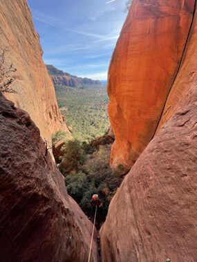
A multi-tiered alcove system with back to back rappels. Located in Far-West Sedona this route is ideal for adventurers camping off the 525. This route is close to a dirt road that is heavily trafficked by local jeep tours, and also borders a private property. Please follow the KML carefully to avoid the private property.
Approach[edit]
Start at Loy Canyon and follow the kml track to the drop in location. Please respect all archaeological sites along your journey.
Descent[edit]
A 15' downclimb into the alcove, followed by 4 rappels under 85' off trees. Anchors are likely to be removed if the property owner is disturbed. For this reason, it is recommended that all canyoneers bring anchor building materials and a retrievable anchor. Move quietly once you are back on the east side of Loy Butte and near the drop in.
Exit[edit]
Follow the kml track closely and avoid the private property. Please keep noise levels very low, at least until you reach the main road.
Red tape[edit]
Trespassing will likely lead to conflict with the property owner. Let's do our best to preserve the peace and protect our access.
Beta sites[edit]
 sedonacanyoneering.com : Chiquitos
Trip reports and media[edit]
Background[edit]
Route Established By: Eric Moorcroft, Jason First, Cooper Smith, And Wayne Herrick.
