Cibecue Creek
| Rating: | |||||||||||||||||||||||||||||||
|---|---|---|---|---|---|---|---|---|---|---|---|---|---|---|---|---|---|---|---|---|---|---|---|---|---|---|---|---|---|---|---|
| | Raps:2-3, max ↨50ft
Red Tape:Closed to entry Shuttle: Vehicle:Passenger | ||||||||||||||||||||||||||||||
| Location: | |||||||||||||||||||||||||||||||
| Condition Reports: | 13 Apr 2018
"Water was at least 10F degrees greater than Tank and most of the canyon is sunny making it much warmer. Water flow was low enough that jumping (on ro |
||||||||||||||||||||||||||||||
| Best season: | Apr-Sep
|
||||||||||||||||||||||||||||||
| Regions: | |||||||||||||||||||||||||||||||
Introduction[edit]
As of June 2019, The CAC has been in recent discussions with the White Mountain Apache tribe and the canyon is currently closed for recreational and guided use. Please respect the closure until further notice.
One of the best canyons in the region, dry for half way and full Class C towards the end. Usually done as in-and-back trip can also be done as through trip approaching from the top. Permit is required, and you need to hire Indian guide in order to visit it.
Approach[edit]
Shortest approach is to descend Tank Canyon and rappel into Cibecue Creek just below Falls 3 (counted from the bottom up). Alternatively, the full Cibecue Creek may be an overnight and would require special arrangements with the required White Mountain Apache guide.
The approach from Tank Canyon will take approximately 4.5 hours, involving a 3 hour dry creekbed hike and 4 rappels.
Descent[edit]
- Jump: About 30 minutes down stream from Tank Canyon you arrive at an oasis of cascading wide shallow pools that end in a wide and deep pool ideal for jumping from 5 or 10 foot perches.
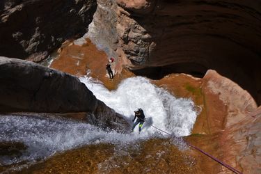
- R1: Bolts, canyon right, 60-feet, 2-tier, mandatory cascade crossing. Although impressive looking, these falls are spread wide and highly aerated making them easy to cross. In addition, the footing is surprisingly grippy due to minerals in the water that prevent alga from growing.
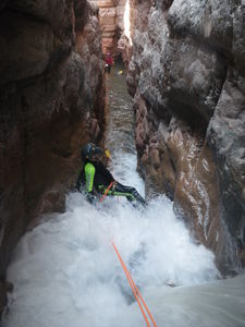
- Corridor: Just below the first rappel is a narrow swim for about 50 feet that slopes up until you can stand. There is a 2-tier falls that must be stemmed down. The top falls are about 6 feet and form a hydraulic that will jettison you into a death siphon if any slip ups are made. On the right is a must-make rock you must get your right foot on. The rock is hardly visible as the flow is heaviest on the right where it pours off in a powerful laminar flow. There is also a ledge a foot or two below the water on the left. It is ideal to get a spotter here if possible. NOTE: IN BETWEEN THESE TWO ROCKS IS A SIPHON OVER 10 FEET DEEP THAT WILL NOT SPIT YOU OUT. Stemming past this point is also not advisable as the walls widen and several canyoneers have fallen down the next falls resulting in broken ankles. NOTE: IT IS NOT ADVISABLE TO STEM HIGH PAST THE SECOND TIER EITHER. This has also resulted in falls and broken ankles on the ledges underwater. Once you have your feet at the bottom of the first 6-foot tier, then it is relatively easy to stem and bridge over the next tier, which drops 15-feet into a channel with friendly hydraulics that will spit you out once you lower down into it. It is easy to stem in ledges that can't be seen but are just a foot under water. NOTE: THE CORRIDOR CAN BE AVOIDED BY CLIMBING UP ON CANYON RIGHT AND HIKING AROUND. The guide will be happy to guide anyone in your group who is not ready for a must-make death siphon.
- Continue: It's about a 30 minute trail and creek walk with many scenic pools and chutes before you arrive at the final rappel. On the way there are cliff dwellings barely visible in the distance on canyon right. On a trip 3/31/18, in 12cfs water, we were able to rappel or stem another corridor between the chute and the final rappel. It is DCL of a large boulder with a shady area underneath}. Normally people walk around or jump to get past the chute. However, we were able to rig an anchor and rappel it, but also to stem it off rope.
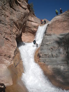
- R2/Jump: Bolts, canyon right, 50-feet. Recommended to leave rope at least 5 feet above the surface of the water as there are usually many people who hike up form the bottom to spend the day at this water hole and it would be dangerous if a swimmer were to tangle or hang from the rope. The rope can be pulled up to any height to make a jumping de-rig into the pool. The guide said people have jumped from the top and not touched bottom. Note: Our group on 3/31/18 in 12 cfs flow (low) was able to rig an anchor from some boulders far off to the side DCL, and rappel into the flow of the waterfall directly, entering from the top on the DCL side of the fall).
Exit[edit]
Below the final rappel at Falls #1, there is a well-worn trail that involves several creek crossings. Exit canyon right about 1/10th mile before the confluence with the Salt River. Your car should be right at the top of the exit scramble. The exit hike takes approximately 30 minutes.
Red tape[edit]
As of June 2019, The CAC has been in recent discussions with the White Mountain Apache tribe and the canyon is currently closed for recreational and guided use. Please respect the closure until further notice.
It is required to hire a White Mountain Apache guide as an escort. The purpose of the guide is for archeological protection and not as a technical canyon guide. You must have an experienced canyon leader in your group. It is also required to hire a driver to move your vehicle from the trailhead to the exit point at the Salt River if doing both Cibecue and Tank Canyons - the White Mountain Apache guide can arrange this. In addition, a hiking permit is required and may be obtained online here: http://wmatoutdoor.org/purchase_permit.html for $30 per person.
Beta sites[edit]
 Chris Brennen's Adventure Hikes (Southwest) : Cibecue Creek
 HikeArizona.com : Cibecue Creek
 ToddsHikingGuide.com : Cibeque Creek
 Super Amazing Map : Cibecue Creek
Trip reports and media[edit]
 Mark Kilian's Adventures : Tank & Cibecue Canyon
Background[edit]
Timber Camp is a convenient camping spot not on the reservation and is located 25.9 miles north on AZ60 from the split with AZ70 - fees are 10$ a site per night. Jones Water Campground is another, free option for camping with the same amenities as Timber Camp and is located 16.6 miles north on AZ60 from the split with AZ70.
The first known descent in the modern era was reportedly done by Rich Carlson, Anthony Thompson, and Greg circa 2007. (note: we descended Cibecue during the 2005 ACA rendezvous with Rich, so it was descended by them before 2007)


