City Creek (West Fork)
| Rating: | |||||||||||||||||||||||||||||||
|---|---|---|---|---|---|---|---|---|---|---|---|---|---|---|---|---|---|---|---|---|---|---|---|---|---|---|---|---|---|---|---|
| | Difficulty:3B I (v3a2 I) Raps:1+?, max ↨80ft
Red Tape:No permit required Shuttle:None Vehicle:Passenger Rock type:Granite | ||||||||||||||||||||||||||||||
| Start: | |||||||||||||||||||||||||||||||
| Parking: | |||||||||||||||||||||||||||||||
| Condition Reports: | 26 Mar 2025
"First run down through the hanging pothole and slimy rappel (see pic)! We trimmed the brush quite a bit leading up to the drop, but not so much after |
||||||||||||||||||||||||||||||
| Best season: | Nov-Apr
|
||||||||||||||||||||||||||||||
| Regions: | |||||||||||||||||||||||||||||||
Introduction[edit]
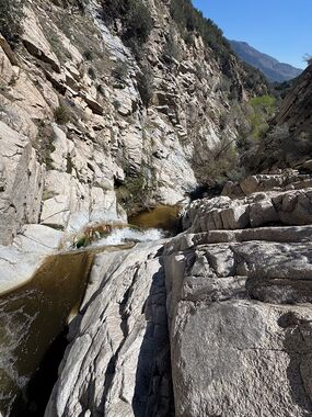
This section of City Creek West Fork seems to a be one trick pony, with one rappel through a hanging pothole and 50 feet of super slippery slope at 34.19675, -117.19493.
Approach[edit]
Park at the Forest Service building and Fire Station at the huge pull-off on highway 330 to Running Springs at 34.185154, -117.180888. Follow the pave gated road to the NW down to City Creek (0.3mi), cross City Creek and continue on the dirt road crossing tributaries along the way until you reach a spot where the road goes around an old cattle guard (1.5mi total). On the right side (NE direction) there is a fire break bulldozed through the Manzanitas with a rocky soil base. Climb up the fire break and down into a saddle (1.7mi total). At 34.19729, -117.19651 look for a short path cut through the brush to the right side (NE direction) that leads to a steep slope down into City Creek.
Descent[edit]
Follow City Creek West Fork down stream 500 feet to the only rappel through the hanging pothole. There are some suitable bushes DCL for an anchor, and 2 huge poison oak bushes there too! The pothole could be jumped as it is deep, but depth check first and make sure it's clear of logs and stick. The rappel slope beyond the pothole is low angle and VERY slippery (when wet). 80 feet of rope will make it from the bush to the big pool at the bottom.
Exit[edit]
Continue downstream through often thick brush to 34.19249, -117.19184, and climb up the steep slope DCR back to the road. There are sometimes shelves of old stream bed on the right or left of City Creek which makes travel easier, but these shelves also have clusters of poison oak. Once on the road head back the way you approached. NOTE: there is another mile of canyon beyond this exit point that might have some other cool features.
Red tape[edit]
Beta sites[edit]
Trip reports and media[edit]
Background[edit]
It's all Jordan's fault! :)
