Clark's Canyon
| Rating: | |||||||||||||||||||||||||||||||
|---|---|---|---|---|---|---|---|---|---|---|---|---|---|---|---|---|---|---|---|---|---|---|---|---|---|---|---|---|---|---|---|
| | Difficulty:3B III (v3a2 III) Raps:4, max ↨70ft
Red Tape:No permit required Shuttle: Vehicle:Passenger Rock type:Granite | ||||||||||||||||||||||||||||||
| Start: | |||||||||||||||||||||||||||||||
| Parking: | |||||||||||||||||||||||||||||||
| Condition Reports: | |||||||||||||||||||||||||||||||
| Best season: | AVOID Summer
|
||||||||||||||||||||||||||||||
| Regions: | |||||||||||||||||||||||||||||||
Introduction[edit]
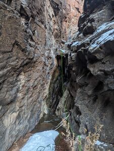
Awesome deep gorge of pre-cambrian granite, but dumps you out into a bushwhack hell-hole of roses, willows, and vines. Pay to play! Combine with other nearby canyons for a better time.
Approach[edit]
Go straight at the Mica Mine/Rough Canyon turnoff and take Clark's Bench rim all the way to the canyon. Rappel down the sandstone or hike another mile to scramble down. OR Go down Rough Canyon or Tabaguache Jeep park and take the bench up the south side of the canyon.
Descent[edit]
R1 - ~40ft: Rock pinch RDC dumps you out onto a slope at the bottom which could be a sheet of ice in winter. Continue the rappel down ~70ft or take a bumpy slide into the next puddle.
Downclimb Section. Take RDC under boulder for easiest route
R2 - ~60ft: Rock pinch LDC or log jam (>100ft) to solid landing
R3 - ~30ft: Chockstone RDC. Sometimes wet, but possible to rappel/stem out and away.
Downclimb. ---end technical section--- kind of
Canyon dumps you out into an awful bushwhack and your options are as follows: 1. Follow the watercourse through a half mile of bushwhacking with mixed downclimbing and one short rappel from a tree. 2. Take a right and up the loose side hill to gain the ridge and take the slickrock field down to connect with one of Shaylee's Canyons Both aim to reconnect with Rough Canyon
Exit[edit]
Take Roguh Canyon or Tabaguache back


