Congustro
Jump to navigation
Jump to search
Also known as: El Congustro; Barranco de Congustro.
| Rating: | |||||||||||||||||||||||||||||||
|---|---|---|---|---|---|---|---|---|---|---|---|---|---|---|---|---|---|---|---|---|---|---|---|---|---|---|---|---|---|---|---|
| | Raps:max ↨49ft
Red Tape: Shuttle:None Rock type:Limestone | ||||||||||||||||||||||||||||||
| Location: | |||||||||||||||||||||||||||||||
| Condition Reports: | |||||||||||||||||||||||||||||||
| Best season: | Anytime
|
||||||||||||||||||||||||||||||
| Regions: | |||||||||||||||||||||||||||||||
GPS data automatically extracted from descente-canyon.com, please visit their site for more detailed information.
Introduction
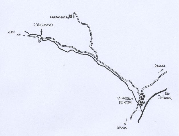
Acceso desde: La PUEBLA DE RODA. Desvio a Esdolomada y Merli. El congosto se encuentra casi junto a la aislada “Casa Molinet”
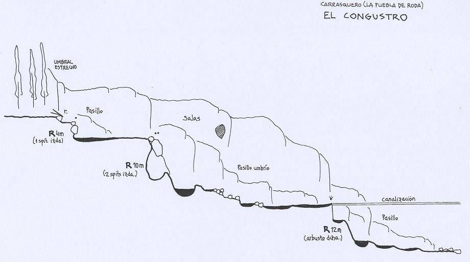
Altura de rápel mas largo: 12 m
Información del caudal: Acostumbra a correr un pequeño caudal. Agua turbia en ocasiones
Material necesario: 2 x 15 y la de socorro
Neopreno: Si
Material de instalación: Aconsejable llevar material de instalación de repuesto. Spits en buen estado y arbusto
Epoca: Cualquier época del año
Observaciones: Al ser zona de margas el cauce presenta a veces un fino barro gris muy abundante que llega a tapizar incluso las paredes del congosto
Horario de aproximación: Inmediato
Horario de descenso: Media hora escasa
Horario de retorno: 10 mn
Toponímia: Correcta. Este estrecho del barranco es conocido como “el Congustro”
Mapa: IGN 1:25.000 (251-I, La Puebla de Roda)
Zona o macizo: Interfluvio entre el TURBÓN y los MORRONES DE GÜEL
Cuenca: Río Isábena
Altura en inicio: 810 msnm
Altura en final: 790 msnm
Longitud: No llega a los 100 m
Desnivel: Poco más de 20 m
Carácter: Desfiladero muy breve y de pequeñas dimensiones pero profundo, estrecho y muy bien esculpido. Completamente limpio de vegetación
Tipo de roca: Calcáreo algo escamoso
Combinable con el descenso de:Está próximo el Congosto de Obarra. Y otros de menor entidad (Riu Blanc, Salt del Llop, Sant Cerni, Castrocit...)
Approach
Combinación de vehículos: Innecesaria
Evidente desde la carretera. La entrada al congosto pasa desapercibida junto a una visible chopera.
Descent
Se trata de un pasillo estrecho, muy disimulado en un pequeño relieve del terreno. Zona solitaria.
Escapes: En la cabecera del tercer rápel, a uno u otro lado. Fácil
Exit
También evidente, por la carretera o bordeando el congosto.
Red tape
Beta sites
 Descente-Canyon.com : Congustro
 Barranquismo.net : Congustro
- Wiki-Infobarrancos : Barranco El Congustro (http://infobarrancos.es/)
Trip reports and media
Background
Sin datos. Los espits son relativamente recientes.