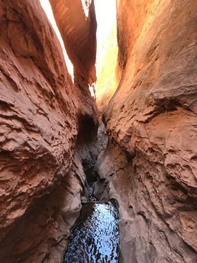
Conundrum Canyon
| Rating: | |||||||||||||||||||||||||||||||
|---|---|---|---|---|---|---|---|---|---|---|---|---|---|---|---|---|---|---|---|---|---|---|---|---|---|---|---|---|---|---|---|
| | Difficulty:3B I (v3a2 I) Raps:1, max ↨50ft
Red Tape: Shuttle:None Vehicle:High Clearance Rock type:Sandstone | ||||||||||||||||||||||||||||||
| Location: | |||||||||||||||||||||||||||||||
| Condition Reports: | 16 Oct 2023
"On our way out of town, we decided to check out Conundrum and were pleasantly surprised. The road conditions were great, and we parked at the recommen |
||||||||||||||||||||||||||||||
| Best season: | Spring, Summer, Fall
|
||||||||||||||||||||||||||||||
| Regions: | |||||||||||||||||||||||||||||||
Introduction[edit]
Spring-fed creek with crystal clear water flowing through a sandstone slot with walls up to 100 feet.
One rappel off a large tire: drop is 40 feet but anchor is another 10 feet back. If flash flood removes anchor there should be other anchor material available. One 120 foot rope is recommended. One downclimb about 10 feet which can be stemmed over. Narrows section is narrow enough to stem / bridge for about 200 feet. Pools under waist depth as of May 2023.
Very scenic. A great way to cool off the feet, clean off your shoes, ropes and gear on the way home from a day or days in Northwash or Ticaboo.
High clearance vehicle needed, 4x4 useful (or required) depending on season / road conditions. Road may be impassable after heavy rains or in early spring as there are numerous creek crossings.
Approach[edit]
Follow the gravel road to the bottom of Crescent Creek from the trailhead parking. Once in the canyon, continue downstream. You will pass Lecleed Spring on DCL, and the water flow in the creek will increase. From this point, the steam will be mostly ankle-deep deep, with some knee-deep sections towards the canyon's end.
Descent[edit]
Exit[edit]
After exiting the canyon, scramble up a loose rock field to the old mining road above. Then follow the road to the left, and it will intersect the main gravel road in a few minutes. Follow that road back to your car.
Red tape[edit]
Beta sites[edit]
 RoadTripRyan.com : Conundrum Canyon
 Super Amazing Map : Crescent Creek aka Conundrum Canyon
 Climb-Utah.com : Crescent Creek - Henry Mountains
