Cortright Creek
| Rating: | |||||||||||||||||||||||||||||||
|---|---|---|---|---|---|---|---|---|---|---|---|---|---|---|---|---|---|---|---|---|---|---|---|---|---|---|---|---|---|---|---|
| | Raps:4-5, max ↨80ft
Red Tape:No permit required Shuttle:Required 4mi Vehicle:Passenger | ||||||||||||||||||||||||||||||
| Start: | |||||||||||||||||||||||||||||||
| Parking: | |||||||||||||||||||||||||||||||
| Shuttle: | |||||||||||||||||||||||||||||||
| Condition Reports: | 6 Sep 2025
"Cortright turned out to be a delightful descent with neat pools, cool geology, and much luscious green moss. It would probably be run all the time if |
||||||||||||||||||||||||||||||
| Best season: | Jul-Sept
|
||||||||||||||||||||||||||||||
| Regions: | |||||||||||||||||||||||||||||||
Introduction[edit]
Cortright Creek is a lovely tributary of Clear Creek, with clear water, beautiful pools, interesting geology, and lush moss. Cortright's final rappel is directly into the larger Clear Creek with a 1.3mi exit downstream, making it Cortright a moderately high pay-to-play. (It might be possible to exit Cortright DCL before or after the final rappel, and navigate back up to the highway which would obviate the need for the long creek walk and the shuttle. This would turn Cortright into a lovely half-day adventure. This option has not yet been explored.)
- Cortright is likely best done in late summer when flow on Clear Creek is lower and easier to navigate.
- Best flow checkpoint is at the campground bridge (Clear Creek) where you exit.
Approach[edit]
Park in a paved pullout just north of the bridge over Cortright Creek. From the parking area cross the highway, jump the guardrail, and head down slopes to the west to enter the creek. There are a number of elk trails in the area and the going is pretty easy.
Descent[edit]
Cortright Creek[edit]
A short distance downstream the fun begins. There are a couple of minor downclimbs. Use caution as it can be slippery. A handline might be appropriate in some spots.
- R1: 25ft from small tree DCR. Below the falls, pass through an interesting section of bedrock
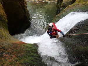
- R2: The creek abruptly plunges down a two-tier drop. The mid-pool was a jumble of fallen logs in 2025. Downclimb carefully or skirt around DCL to rappel 40ft from a tree to avoid the mess.
- R3: 30ft two tier drop from a log spanning the creek. First tier can be slid (carefully). Beware potential hydraulic at the bottom of the falls. (The original beta mentions downclimbing a steep mossy gully DCR to bypass the second tier, although this looked tricky to get to.) When the log gets swept out eventually, this drop will probably need to be bolted.
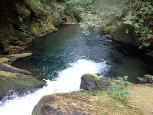
Just ahead, atop R4, is a giant bathtub / infinity pool.
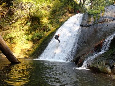
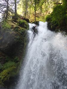
- R4: 65ft photogenic falls from convenient tree DCR. See banner photo above. (The DCL side of the falls is a two-stage drop and looks interesting - although anchors on that side are thin.)
- R5: 80ft from a log into Clear Creek below. (If Clear Creek is running high, it looks feasible to skip the rappel and exit up slopes DCL and return to the highway in about 0.3mi. Use caution on the bridge as the highway shoulders are not that wide.)
Clear Creek[edit]
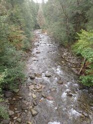
On entering Clear Creek the water will at least double. Head downstream through this scenic canyon. Expect big water and strong current in places. There are no waterfalls, but occasional boulder gardens and rapids to navigate. Floating/body surfing is possible in places, but swiftwater training strongly recommended to avoid potential entrapment hazards.
- At 0.5mi, Dam Creek enters DCL with a scenic water slide.
- At about 0.1mi, just before the highway bridge overhead, the entire creek was barricaded by a truly giant logjam. Climb up DCL and jump into the pool below.
- Pass under the bridge, watching out for numerous pieces of rebar scattered all over the place (left over from bridge construction).
Continue ahead for a couple last floats and exit DCR up a user trail just before the campground bridge.
Exit[edit]
Cross the bridge and follow the road west about 0.3mi to the day-use parking area and your waiting car.
Red tape[edit]
- Park at the day use area inside La Wis Wis campground. As of 2025, there were no parking signs along the road to the bridge, and the Blue Hole Trail was also close to day-use parking. Another way around the parking problem would be to score a campsite.
- The campground is open May through September. Outside of this time, you may need to park up on the shoulder of Hwy 12.
Beta sites[edit]
 Super Amazing Map : Cortright Creek and Clear Fork of the Cowlitz River
 CanyoneeringNorthwest.com (archive.org) : Cortright Creek
Trip reports and media[edit]
Background[edit]
First modern documented descent by Kevin Clark, Eric Rutz, and Trey Schutrumpf in Sept 2025. From the condition of the anchors, no one had visited the creek in many years.
Future Explorations[edit]
Might be worth seeing if it's possible to exit above or below R4 on Cortright. Below R4, it might be possible to go upstream and ascend a short distance through a weakness in the cliffs. This might allow a quick return to the highway. Marked at "Alt-Exit" on the map.
