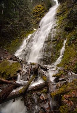
Covell Creek (West Fork)
| Rating: | |||||||||||||||||||||||||||||||
|---|---|---|---|---|---|---|---|---|---|---|---|---|---|---|---|---|---|---|---|---|---|---|---|---|---|---|---|---|---|---|---|
| | Raps:4-6, max ↨200ft
Red Tape:No permit required Shuttle:None Vehicle:Passenger | ||||||||||||||||||||||||||||||
| Start: | |||||||||||||||||||||||||||||||
| Parking: | |||||||||||||||||||||||||||||||
| Condition Reports: | 24 Jun 2024
"Canyon terrain seems drastically different from the last reported trip. Landslide/blowdowns have clogged the canyon with debris. Handful of anchors ne |
||||||||||||||||||||||||||||||
| Best season: | Winter - Spring
|
||||||||||||||||||||||||||||||
| Regions: | |||||||||||||||||||||||||||||||
Introduction[edit]
Covell Creek provides ample fun for the canyoneer looking for canyoning opportunities in the Randle area. Covell is a great option when other nearby canyons are running high. With an easy approach and exit, the canyon features some big waterfalls and is fairly open with a short narrows that adds to the appeal. Flows reduce dramatically in the summer months, but the creek's low elevation and easy access make it a great option in the fall, winter, and spring.
Covell offers two main options... and an experienced team could run both of them in a single day.
- West Fork Covell Creek - this page describes a descent of the west fork
- Main Fork Covell Creek
Note that both forks converge below Angel Falls at about 2000ft elevation where a trail crosses. We'll call this spot "the confluence." It's a good place to check the flow on both creeks.
Be aware: this area is quite popular with hikers. Use caution when deploying your rope on some rappels.
- Watershed: 1.16mi^2.
Approach[edit]
Covell Creek is located just south of the Cispus Environmental Learning Center. Park at the location indicated and follow the trail to Angel Falls. Several other side trails fork off of the main trail so be aware of this on the approach. Just before reaching Angel Falls, the trail crosses the main fork of Covell Creek. Keep following the trail. Just ahead is Angel Falls (bottom of R2). Continue on up the Burley Mountain trail. After several switchbacks, the trail starts to return to the creek. At about: 46.42314, -121.85395 at ~2500ft elevation, there's an easy place to drop West Fork. Suit up and head downstream.
Descent[edit]
DCL = Down Canyon Left, DCR = Down Canyon Right
West Fork
Push on through to a dirty downclimb / rappel, followed by a nice area of bedrock. The steep, slippery downclimb can be protected with a handline/rappel off a small alder(?) DCL (~90' ramp). The remainder before Angel Falls can easily be downclimbed in the creek. Just ahead is Angel Falls.
Note: Angel Falls consists of R1 and R2 and is a multi-pitch rappel. It's almost like one long ramp.
- R1: 190' from a tree DCR.
- R2: 190' with two anchor options: Option A from a tree DCL about 30' up & back from the lip of the main falls, with a tricky stance but free of shrubbery. Option B from a tree DCR just below a root ball, also 30' up from the lip of the main falls. Other than a few thorny shrubs, Option B is a nice place to sit and anchor manage. Both lines keep you in the dispersed flow. With a 300'/200' rope combo you could reach the tree DCL right at the lip with a nice platform - this would likely keep the rappeller completely out of the flow for the 2nd pitch.
After R2, head downstream to the confluence. The water flow doubles (or more) as the main fork of Covell Creek enters DCR. (After this the beta is the same as the main fork.)
Below the Confluence: (BC)
Continue downstream with 1-2 downclimbs until you reach BC-R1. If flow is too high, climb back up to the main trail and exit.
- BC-R1: 75' from fallen log DCR into a nice narrows.
- BC-R2: 75' from a tree DCL. This is Covell Creek Falls and is a great spot for photos. Signs around the watercourse request hikers to remain on the trail to avoid trampling the fragile plant life below the falls. Try to remain in the creek bed to access photo spots, and/or if continuing downstream.
Two established trails connect and travel under the falls. Exit canyon right to return to your cars on trail. At the immediate junction, head downhill, then bushwhack a short bit to the road. Hike up the road a short ways to your cars. Alternatively, a longer, more scenic exit takes the right fork at that junction, and wraps around a nice cliff band. This will take you directly to your cars.
Below Covell Creek Falls is a high tourist area as there's a trail just above the creek DCR. Leaving fixed anchors is not recommended.
- BC-R3: 20ft just below Covell Creek Falls. Anchor off a fallen log spanning the creek.
- BC-R4: 20ft drop a short distance downstream. Anchor off a fallen log spanning the creek.
There are a few more short drops further downstream, but they may not be worth your time. It's an easy exit up DCR to the trail.
Exit[edit]
Exit immediately up DCR to the well-maintained trail just above the creek. Head downstream following the trail to where the old bridge was. The new trail loops back toward the parking area. Wahoo!
Red tape[edit]
None.
Beta sites[edit]
Trip reports and media[edit]
Facebook Album - First Descent on 12/30/2017
Background[edit]
This route was first descended on a cold winter December day (12/30/2017) by Barry Specht, Ryan Ernst, Haruka-James Lipscomb, and Tiffanie Lin.
