Curly Creek
| Rating: | |||||||||||||||||||||||||||||||
|---|---|---|---|---|---|---|---|---|---|---|---|---|---|---|---|---|---|---|---|---|---|---|---|---|---|---|---|---|---|---|---|
| | Raps:1-2, max ↨65ft
Red Tape:No permit required Shuttle:Optional Vehicle:Passenger | ||||||||||||||||||||||||||||||
| Location: | |||||||||||||||||||||||||||||||
| Condition Reports: | 30 Sep 2018
"Curley Creek appeared dry except for a few pools, but we went to run it anyway. Good to scope out the falls in dry conditions. We spent some time di |
||||||||||||||||||||||||||||||
| Best season: | Jul-Sept, BEST in July
|
||||||||||||||||||||||||||||||
| Regions: | |||||||||||||||||||||||||||||||
Introduction[edit]
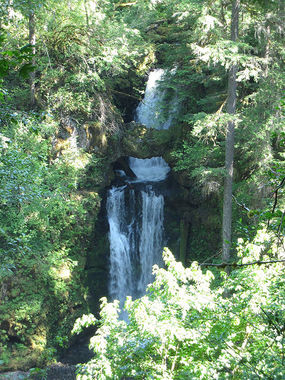
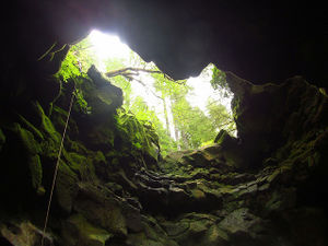
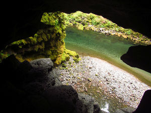
Not a major objective, but Curly Creek Falls is one of the most unique waterfalls in Washington State. Per the Northwest Waterfall Survey: "Having two arches spanning the falls places Curly Creek among a globally exclusive list; there may be only a handful of waterfalls on the entire planet able to make that claim." It's suspected that the geology of this area is the result of the creek cutting through a lava tunnel. This waterfall is something of a tourist attraction - with a viewpoint located high up on the embankment on the north side of the Lewis River. The creek runs high in the early season, but dries up completely (or goes entirely underground?) somewhere in July / August.
Curly is probably best to run when there's some water, but not too much.
- In high flow: rappelling the falls directly could be dangerous. With the pothole full, the lower arch becomes a siphon.
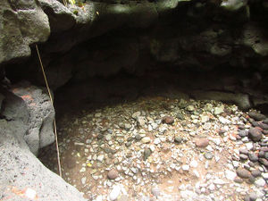
- When dry, the falls presents a rather unusual feature in the Pacific NW: a keeper pothole at the bottom of R1.
Also: consider the height of the Lewis River before running this falls. In higher flow it may be difficult to cross or follow the southern bank. See "Exit" below.
Directions[edit]
Lower Trailhead[edit]
From the junction of FR-90 (Lewis River Road) and Curly Creek Rd follow FR-90 east for 0.9mi. Take a sharp left onto FR-9039 and drive down the hill 0.6mi to a parking area on the left before the bridge.
Checkpoint #1: Lewis River[edit]
Walk out onto the bridge to check the Lewis River. The river height may be important as you'll likely need cross it or follow the south shore to get back to the lower parking area.
Checkpoint #2: Curly Creek[edit]
From the lower parking area, drive across the bridge and up the hill for 0.4mi. Turn off left into the parking area for Curly Creek. Walk in on a short trail, turning right at the junction, to an obvious viewpoint of the falls. The view isn't great, but it's the best checkpoint for water height on the creek.
Upper Trailhead[edit]
Shuttle or walk the road back up to FR-90. Turn right and continue west past Curly Creek Rd for 0.2mi and take the first right on an unmarked dirt road leading to a dispersed campsite. Park at first opportunity in pullout on the left.
Approach[edit]
From the old campground, bushwhack northwesterly and downhill until you intersect Curly Creek. Drop down into the creek wherever is easiest and make your way downstream to the top of the falls. Just before the falls the creek passes through some interesting areas of water-carved basalt. Expect a minor downclimb or three. Distance to the top of the falls is about 0.25mi and takes about 10min. Do not eat any of the poisonous mushrooms along the way.
Descent[edit]
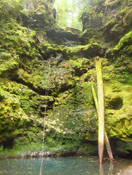
Use caution as Curley Creek is a very unusual drop. Imagine the first pitch as rappelling into a vertical silo with two holes punched out in the side part way down.
- R1: 50ft. We anchored off a tree just above the creekbed DCR. Consider extending the powerpoint for a cleaner pull from below. Do NOT rappel all the way to the bottom of this pitch as it will deposit you in the bottom of the silo in a keeper pothole. Instead, exit the rappel onto a not-that-wide ledge that leads to a short downclimb to a larger ledge just below both arches. There is room for 2-3 people here. Use caution when traversing the ledge as it can be slick. Confirm there are sufficient natural features present for the R2 anchor BEFORE pulling your rope down. In September 2018 there were several options for anchors.
- R2: 65ft. From the ledge, we climbed down into a narrow person-sized tunnel just DCR and under the lower natural arch - and anchored off a large log firmly wedged in place among the rocks. (In high flow, this tunnel would be full of fast-moving water.) It is likely that this anchor will need to be replaced every year after the winter floods. We rappelled right out the mouth of the tunnel; it was quite easy to get on rappel. The rappel goes into a deep calm pool which is freezing COLD. The pool looks deceptively shallow from above, but it's a swimmer. In September, the pool at the bottom of the falls was far colder than the Lewis River nearby. While Curly Creek appears dry in late season it's likely that the creek goes underground and emerges via several springs at/near the foot of the falls. We found one small actively-flowing spring nearby.
Other Notes[edit]
- The keeper at the bottom of the silo is about 8-10ft deep and has no exit that a human could pass through. If you should rappel in, getting out might require ascending a rope, a partner assist (maybe two partners), and/or spending an inordinate amount of time & energy moving rocks and piling them up high enough to escape. The bottom of the silo is likely full of water when the creek is running at any strength.
- It might be possible to rappel over the top of the uppermost arch and down, but the rope pull likely would be difficult... and it's likely nowhere near as fun. This might be the way to go in high water conditions, however. (Instead of trying to retrieve the rope from below, it might be better to tie the rope off, rappel - and just hike back to the top of the falls after to get your rope.)
- Given the tourist viewpoint across the river, please use natural colored webbing or black. Waterfall photographers do not appreciate bright red slings atop the drop. If possible, try to build your anchors so they are not in direct line of sight with the viewpoint (easy).
Exit[edit]
In late summer, water on the Lewis River is lower and you can follow the south bank all the way back to your car (~0.4mi). Even in low water conditions there are short stints of swimming and you may need to hop into the water briefly and pull yourself along a rocky wall. Expect a little wading, scrambling, some boulder hopping, talus slopes, and rocky slopes. Closer to the bridge, you can follow fishing trails along the bank which makes for easy travel. Just before the bridge, look for a muddy trail on your right that leads steeply upwards back into the lower parking area.
In high water it might be possible to exit up a steep rocky ramp right at the foot of Curly Creek Falls and exit atop the cliff, but we did not explore that direction. (If feasible, this might enable an out & back from the upper trailhead.) Another possibility might be to cross the Lewis River and exit to the Lewis River Trail higher up the embankment on the north side. Reportedly waterfall photographers use this route to access the falls.
Red tape[edit]
None.
Beta sites[edit]
Trip reports and media[edit]
Background[edit]
Falls was first run by Brian Forrest in September 2018.
