Cussed Hollow
| Rating: | |||||||||||||||||||||||||||||||
|---|---|---|---|---|---|---|---|---|---|---|---|---|---|---|---|---|---|---|---|---|---|---|---|---|---|---|---|---|---|---|---|
| | Raps:6, max ↨70ft
Red Tape:No permit required Shuttle:None Vehicle:Passenger | ||||||||||||||||||||||||||||||
| Start: | |||||||||||||||||||||||||||||||
| Parking: | |||||||||||||||||||||||||||||||
| Condition Reports: | 25 Aug 2024
"There was a bit of cussing in Cussed Hollow. This one was a higher pay to play than out team anticipated. The hike in is a solid work out and no jok |
||||||||||||||||||||||||||||||
| Best season: | Jul-Sept
|
||||||||||||||||||||||||||||||
| Regions: | |||||||||||||||||||||||||||||||
Introduction[edit]
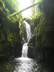
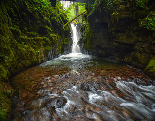
A somewhat high pay-to-play canyon per a long steep approach and a long exit, but your payoff includes a gorgeous narrows, nice rappels, few swims, jumps, and slides go a long way towards making up for it. It would get run all the time if the access was easier.
- Watershed: 5.12mi^2.
Approach[edit]
Follow the Lewis River trail west about 0.3mi to a bridge crossing Cussed Creek. Turn right at the junction on the far side and follow the trail upwards (steep!) for ~0.9mi to about ~2400' elevation (approx. 46.15262, -121.90974). Break off the trail here and traverse/bushwhack north at about the same elevation for ~0.5mi to a tributary creek. This trib has steep sides in places, but there's an easy game trail crossing it at about 46.15974, -121.90920. On the far side, bushwhack up to gain the ridge and follow it east and downwards until you can drop into a small dell on the north side. Follow the dell east until you reach Cussed Creek. (Total distance from the trib: ~0.25mi.) The technical section starts just downstream. Total distance: ~2.4mi one-way.
- One can also thrash in via the east side, but it's equally steep and long. The upside to the west approach is being able to gauge the flow while you’re walking and a trail for a decent stretch of the way.
Descent[edit]
Be sure to depth check all slides and jumps. Just because it was a great jump last year...
- R1/J1: Single bolt DCL. Two stage: 20' rap followed by horizonal pool, then 5' shallow-entry jump into shallow pool
- R2: Single bolt DCR. Two stage: 15' rap then 12’. Second tier possible shallow jump.
- J2: 8-10ft quasi-technical jump (small landing area) into a deep pool. (Or rappel from bolt DCR.)
- S2: The Corkscrew - 10’ curved slide into deep pool. (Possible shallow jump DCR of the chute.)
- R3/J3: 45' rap from single bolt DCR, or 10’ rap to ledge then 30’ shallow-entry jump into 10-12’ deep pool. There is a large log in the pool as of 2024.
- J4: 10ft.
0.25 mile very pleasant, grippy creek walk with a few log jams and minor obstacles.
- A few DCs and a 5' jump
- R4: 15ft blocky rappel from single (easy to miss, located high and ten feet back from edge) bolt DCR.
- R5: 70'. Sharp edges present; creeping the rope is recommended.
- High water: dry line 60' from tree DCR.
- Low water: anchor on large log DCL into the Monsoon Room.
0.25 mile pleasant, grippy creek walk through boulder garden. Several log jams and lots of climbing around or over boulders. Some very nice sections of bedrock below.
- R6: 30' from log DCL.
Short creek walk to the bridge you hiked in on. Easy access DCR to the bridge.
Exit[edit]
Follow the trail 0.3 miles back to your car.
Red tape[edit]
Starting in 2021: between June 15 and Sept 30, a reservation permit is required to park along a 14mi stretch of FR 90. Parking in this area is limited to one of six different recreational sites with a limited number of permits issued for each day. Reservation Permits are available from recreation.gov.
- Map of the restricted parking area: https://www.fs.usda.gov/Internet/FSE_DOCUMENTS/fseprd910851.pdf
- The best parking area for Cussed Hollow is Crab Creek. (Parking at the Lower Falls will also require a NW Forest Pass.)
Beta sites[edit]
Trip reports and media[edit]
https://www.youtube.com/watch?v=Q6qMI7JuE2k
Low water flow 2023 https://youtu.be/51XmZ5dPCaY


