Dalles Creek
| Rating: | |||||||||||||||||||||||||||||||
|---|---|---|---|---|---|---|---|---|---|---|---|---|---|---|---|---|---|---|---|---|---|---|---|---|---|---|---|---|---|---|---|
| | Raps:3-4, max ↨150ft
Red Tape:No permit required Shuttle:None Vehicle:Passenger | ||||||||||||||||||||||||||||||
| Location: | |||||||||||||||||||||||||||||||
| Condition Reports: | 17 May 2015
"Scouting trip; low-moderate flow; very low snowpack year, most of the snow in the drainage area has melted |
||||||||||||||||||||||||||||||
| Best season: | Spring
|
||||||||||||||||||||||||||||||
| Regions: | |||||||||||||||||||||||||||||||
Introduction[edit]
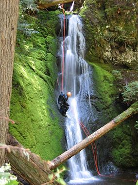
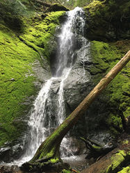
Dalles Creek is a small tributary of the White River, located in Mount Baker-Snoqualmie National Forest, Pierce County, Washington near the town of Greenwater. The canyon is probably best enjoyed in spring soon after the snowmelt as the drainage area is small. A well-maintained and scenic trail provides for an enjoyable approach. The descent consists of two waterfalls separated by about 1,000 feet of stream walking.
Approach[edit]
Parking is located on the east side of WA-410, about 0.3 mile south of the Skookum Falls viewpoint. This is the trailhead for Palisades Trail 1198, a popular trail for hiking and mountain biking. Follow the trail about 0.25 mile to a trail junction with a prominent marker. Proceed left on Palisades Trail 1198. Approximately 0.75 mile farther, the trail nears Lower Dalles Creek Falls. A short spur trail leads directly to the bottom of the falls, where the East Fork and West Fork of Dalles Creek converge. This spur trail serves as a convenient place to check water flow conditions and to access the main trail at the end of the descent.
Continue up the trail as it switchbacks along the West Fork past moss-covered basalt cliffs. Stairs aid in climbing the steepest section before the trail turns southward and crosses the West Fork on a single wood plank, followed by the East Fork on a log bridge. To check water flow conditions, a 500 foot off-trail hike upstream leads to the bottom of Upper Dalles Creek Falls.
After crossing the East Fork on the log bridge, continue on Palisades Trail 1198 to an overlook. Skookum Falls can be seen across the White River. Continue up the trail as it trends east and approaches the steep canyon rim. At the point nearest the creek, you will be able to hear but not see the Upper Falls below. About 600 feet past the switchback, take an ESE bearing off trail to follow the canyon rim. There is very little underbrush, so bushwhacking is easy. Soon, a game trail leads down to the East Fork, about 500 feet upstream of the Upper Falls.
Descent[edit]
- R1 (Upper Dalles Creek Falls): 30' from downed log in watercourse
- R2 (Lower Dalles Creek Falls): ~280' combination cascade-horsetail falls that can be rappelled in several stages (some pitches cannot be seen from the top of the falls). The following previously-used anchors can be seen from the top of the falls:
- R2a: 20' from standing tree in watercourse
- R2b: unknown distance from standing tree in watercourse
NOTICE: Only the first two anchors could be verified for R2 (Lower Dalles Creek Falls) during a scouting trip on 17 May 2015. Refer to canyoneeringnorthwest.com for additional beta.
Exit[edit]
From the bottom of Lower Dalles Creek Falls, use the short spur trail to access Palisades Trail 1198, and follow the trail back to the parking area. Below Lower Dalles Creek Falls, the creek is overgrown with brush, and navigating through it is ill-advised.
Red tape[edit]
Any one of the following passes is required to park at the trailhead:
Beta sites[edit]
 CanyoneeringNorthwest.com (archive.org) : Dalles Creek

