Damocles Canyon
| Rating: | |||||||||||||||||||||||||||||||
|---|---|---|---|---|---|---|---|---|---|---|---|---|---|---|---|---|---|---|---|---|---|---|---|---|---|---|---|---|---|---|---|
| | Difficulty:3B I (v2a2 I) Raps:0-2, max ↨15ft
Red Tape:No permit required Shuttle:None Vehicle:Passenger | ||||||||||||||||||||||||||||||
| Start: | |||||||||||||||||||||||||||||||
| Parking: | |||||||||||||||||||||||||||||||
| Condition Reports: | |||||||||||||||||||||||||||||||
| Best season: | BEST in Nov;Dec;Jan;Feb
|
||||||||||||||||||||||||||||||
| Regions: | |||||||||||||||||||||||||||||||
Introduction[edit]
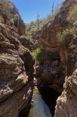
Super short Superstitions canyon with a few pools and downclimbs; possibly one or two very short rappels.
From Tortilla Flat, drive 1.1 miles to a pullout/camping area on the left.
Approach[edit]
From the parking area, hike north to cross the wash and locate the rough, rocky road that continues on the other side. Very soon after leaving the wash the road splits in a Y, take the right branch to continue on the main road. Follow the road north for about .6 miles, then leave the road to the east to drop into the canyon.
Descent[edit]
A few pools and downclimbs and perhaps one or two very short rappels (maybe 15 feet) depending on your comfort with the downclimbs.
After a short narrows section you will reach the confluence with Dionysus Canyon. One final 30’ swimmer guards the exit.
Exit[edit]
Follow the drainage back to your vehicle.
Red tape[edit]
Beta sites[edit]
 Super Amazing Map : Damocles Canyon
 HikeArizona.com : Damocles Canyon
