Davis Creek Canyon
| Rating: | |||||||||||||||||||||||||||||||
|---|---|---|---|---|---|---|---|---|---|---|---|---|---|---|---|---|---|---|---|---|---|---|---|---|---|---|---|---|---|---|---|
| | Raps:5-10, max ↨120ft
Red Tape:No permit required Shuttle:Optional 10 min Vehicle:Passenger | ||||||||||||||||||||||||||||||
| Start: | |||||||||||||||||||||||||||||||
| Parking: | |||||||||||||||||||||||||||||||
| Shuttle: | |||||||||||||||||||||||||||||||
| Condition Reports: | 28 Sep 2025
"Another late season run. I replaced the webbing on R2 (root ball above Upper Davis Falls) as the current webbing was pretty damaged. |
||||||||||||||||||||||||||||||
| Best season: | Aug-Sept
|
||||||||||||||||||||||||||||||
| Regions: | |||||||||||||||||||||||||||||||
Introduction[edit]
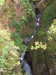
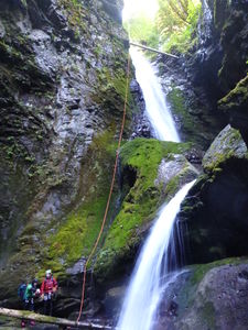
Davis Creek is a classic canyon that always rates as one of the best in Washington. Its beauty is expressed in the deeply incised basalt gorge, abundant moss and ferns, and plentiful waterfalls. Not particularly long (short approach and exit), and not particularly difficult in low to moderate water levels (most pitches are bolted), this canyon is still quite technical, committing, and can be sporting / dangerous in high water. The canyon sports five mandatory rappels of high quality, and three noteworthy jumps in the range of 15-25ft, plus several more smaller ones. With a five minute approach and ten minute exit, this canyon has one of the lowest pay-to-play options anywhere.
Davis Creek is located within both private property and Gifford Pinchot National Forest in Lewis County, Washington. It forms the drainage basin on the south flank of Purcell Mountain, with Cockscomb Mountain and Prairie Mountain on the west, and Davis Mountain on the east.
Waterflow[edit]
The bridge over Davis Creek is the checkpoint for waterflow level, as shown in the reference photos. If you see significantly more water, descending the canyon is not recommended. A possible, unconfirmed escape route before R3 (Davis Creek Falls) may exist, so consider this if the waterflow in the easier beginning part of the canyon seems very high. After descending R3, you may be committed to completing the canyon, which could be quite dangerous in high water.
- A second exit found about 60ft above R5: a deer trail on canyon right leading to the canyon rim, with minor scrambling.
- Expect very cold water even in the middle of summer, but not as cold as glacier melt.
- The closest gauge for water flow appears to be USGS: 14231900 CISPUS RIVER AB YELLOWJACKET CREEK NR RANDLE, WA. However there are still some nuances and getting a visual from the bridge will be your best indication of flows.
- Watershed: ~7.3mi^2. The highest point in the watershed is Purcell Mountain at ~5400ft.
Best Practices[edit]
- Teaching people to rappel for the first time in an aquatic canyon is not a good plan. Much better and safer to become fully proficient with rappel devices outside the canyon in a safe dry environment.
- Two strand rappels (as is done in alpine climbing) can be dangerous in aquatic canyons. Excess rope can be an entanglement hazard in deep pools, the two strands can get coiled around one another to create an obstacle that a rappeller cannot pass, etc. Taking a class in aquatic canyon techniques is strongly recommended.
- Beginners "leading" beginners is a common cause of accidents in canyoneering. Enthusiasm is not a substitute for training by a competent qualified instructor.
Approach[edit]
Lower Parking[edit]
From the junction of Hwy 12 and Hwy 131 in Randle, WA: head east on Hwy 12 for 5.9mi and turn off left/north on Davis Creek Rd. (Be aware: Davis Creek Rd intersects Hwy 12 in two places, but bridge linking the two appears to have been washed out by Davis Creek, so accesss is only possible from the western end.) Follow Davis Creek Rd for 1.1mi to a large "Road Closed" sign at the bridge site. FR-63 turns left/north just before the creek. Park at the bridge or just up FR-63 (unpaved, good gravel road) on the righthand shoulder. There is room for several vehicles. There are some houses immediately nearby, so please be courteous to the neighbors and locals.
Upper Parking[edit]
From the lower parking area, either drive (5min) or hike the road (40min) to the upper parking area.
- At 0.6mi up the road is a bridge crossing Davis Creek. This is the water level checkpoint. If water levels are safe, continue another 0.9mi up the road. Where the road starts to curve back east, there's a huge grassy pullout on the right/east side of the road. Park here.
Hiking In[edit]
Directly across the road from the upper parking area, find a faint use trail that leads straight down toward Davis Creek. As you get close enough to hear the creek, the trail is faint and splits. Stay left to head directly down and drop in right in right above R1. If you go right at the split you'll reach the top of a steep embankment, perhaps 50ft high and may need to do a dirty rappel to drop in and will be well above R1.
Descent[edit]
Special Notes:
- The canyon sees massive floods every year in winter/early spring. Giant logs may appear and disappear. Always check the depth and for hidden obstacles (e.g. logs) prior to jumping into pools. Jumping is a leading cause of canyon injury.
- Please do not add webbing to unlinked bolts. Flood debris can catch in the bolts and weaken/destroy the anchor.
- Beware rockfall at the bottom of R4.
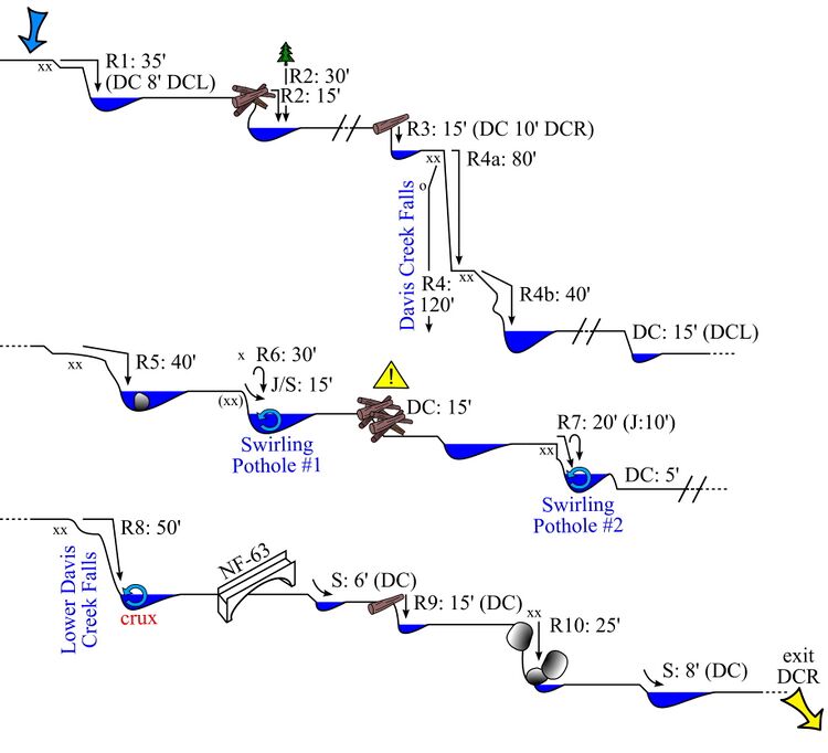
R1: 8ft downclimb DCL or rappel 35ft from two unlinked bolts DCR. Can be jumped with expert shallow entry technique.
R2: 15ft from a log in the logjam. Or 30ft from a tree far DCL up on the bank.
WARNING: Descending R3 commits you to the rest of the canyon. The rappels following can be quite dangerous in high water.
R3 - approach to Upper Davis Falls:
- Low to Moderate Flow: 10ft downclimb DCR down natural staircase.
- High Flow: The small pool may have a hydraulic and is best avoided as it could be difficult to climb out. Rappel 30ft from tree about 10ft up DCR. This provides an easy rappel onto the ledge at the top of R4. You may want to tie the end of the R3 rappel line directly to the R4 bolt station (ala rebelay) so that others have a safety line to clip into.
R4 - Upper Davis Falls: chain-linked anchor DCR, access is protected by a 15ft traverse line from a pair of unlinked bolts.
R4 can be done dry in 1-pitch, or wet in 2-pitches.
- Low to moderate water: Rappel 80ft onto the rib leading to bolts at the pool pouroff. There is an unlinked bolt station (R4+) right at the pour-over of the second tier. From this anchor, the second tier is about 40ft. You can rappel either in the flow or around the flow to a dry landing. Get off rappel halfway down the chute onto a 5" wide ledge for a 20ft jump. The pool is typically 15ft deep or more. Check for wood or new boulders.
- High water: Dry rappel 120ft staying DCR and bypassing the big pool and R4b. Use caution when setting the pull line as there's a crack up near the top that can catch and hold a block. As this rappel is mostly out of the water, it may be best to have the last person rappel two-strand to avoid snagging your rope. There is also a deviation about 10ft down from the main anchor (DCR) that helps to stay out of the flow.
Continue downstream to where a narrow hallway forms. In high flow, you can bypass R5 & R6 by following a deer trail DCR located 50ft upstream of R5. Go up over a rise to a sketchy little downclimb. Follow the bench to the turn and do a 50ft dry rappel that drops back in below log jam. NOTE: It appears possible to continue past this rappel and exit the canyon.
R5 - the v-slot: 40ft from an unlinked double anchor high-up DCR.
There's a boulder in the pool below which migrated its way down the v-slot over many years, see photos further down the page.
R6 - the plunge pool (pothole #1): Slide DCR in the flow, jump from anywhere, or rappel from unlinked double anchor DCL. Unless you know it's clear, always depth check.
Exit over the logjam. This can be awkward on the slippery logs. Throwing a rope around a log to protect the final drop might be a good idea.
R7 - the roundy pool (pothole #2): 10ft jump from DCL, check depth first. Or rappel 20ft from bolts DCR. The waterfall can create a clockwise horizontal recirculating hydraulic in the pool that can be overcome with proper technique. Recommended to zip-line packs.
- Low to Moderate Water: Rappel into the pool. You will land in the whitewater, but it will push you away quickly. Swim DCL to avoid the recirculation and exit the pool.
- High Water: One option is to rappel most of the way down, then flat jump out toward the exit of the pool to avoid the hydraulic. Send the strongest swimmer first (without pack) to swim aggressively DCL to exit the pool. Once the first person has reached safety, throw down the pull side of the rope (secured) in a bag. The first person down can use the pull side of the rope as a zip-line for the packs and as a throw rope (throw the floating bag) for people to grab onto and pull themselves out of the pool. In extreme cases, set up a guided rappel using a potshot (there are several small stones available, but be ready for an alternative if they are gone) and throw the potshot across the pool.
At the exit pour-over there's a small threaded anchor DCR to use as a handhold to assist in dropping down out of the pool.
As you round the corner look up to see the bridge far above.
R8 - Lower Davis Falls: 50ft from bolts high DCR. This is the crux of the canyon. The rock is very slippery. Extending the pull side (need ~70ft of rope) makes for an easier pull (i.e. no need to be swimming / treading water at the bottom while attempting the pull). There was a redirect, please do NOT reinstall. Instead, step over the lip of the waterfalls and continue down DCL. You will land in a hanging pothole and have a dry landing spot. The old redirect put you in the same place. This is part of the private land and the landowner doesn’t want to see webbing that appears to be trash.
- Low to Moderate Water: walk down the chute into the tiny pool and get on a platform DCR at the pouroff to get on rope.
- High Water: set up a hand line to reach the anchor. The hydraulic at the bottom of this falls is the strongest in the canyon. Setting rope length 3-5ft above the whitewater when unweighted is critical. Each rappeller should pause before entering the strong flow and pull up the rope to make sure no knots have formed in the end.
Pass under the bridge. If you see any trash in here, please help us keep the canyon clean by packing it out. If there is something large down there if you send a text to Ryan @ 937-603-6218 and share what you saw it can be removed.
Jump: 6ft from top of falls. Or downclimb carefully DCR. Or rappel from a log DCL.
R9 - Ants on a Log: 15ft from a log, or downclimb with partner-assist.
R10 - Exit Cave: 25ft from two-bolt anchor DCL up in the rocks.
- Low to Moderate Water: Rappel down to an enormous house-sized boulder. Don't miss the rabbit hole and small cave.
- High Water: Rappel around the boulder DCL.
Jump: 8ft from top of the waterfall, landing just past the whitewater.
Exit[edit]
Shortly after the last rappel the canyons opens up. Climb the scree slope DCR to reach the road where you parked the vehicle.
Red tape[edit]
FR-63 passes through a large parcel of private property en route to the upper parking area. Please respect all postings and be courteous to the locals.
Beta sites[edit]
- https://www.canyoningthe406.com/daviscreek
- CanyoneeringNorthwest.com (archive.org)
- Super Amazing Map
Trip reports and media[edit]
https://youtu.be/rdcoYGqU06Q - Davis run Oct 2023
- Davis Creek at extreme levels July 3, 2016
- Facebook album from June 23, 2016 at extreme levels
- Davis at moderate levels
- +
The Power of Water[edit]
Davis sees extreme flow during the winter months, capable of re-arranging the entire canyon. Logjams get moved around and, in 2020, the giant boulder (size of a small car) that was just below R5 abruptly disappeared. It's now underwater at the bottom of a new rappel. Here are a few pics of the boulder from 2017 to 2020:
Background[edit]
From Canyoneering Northwest: The first known descent was made by Matt Bannon and Paul Bauer in September 2002. It was a bold undertaking and was among the first known technical canyoneering descents in Washington. The anchor situation was especially problematic for the first descent party. At one point they had to pre-place a 300 foot rope from the canyon rim in order to do a rappel and then retrieve it later. Robert Cobb made the second known descent in 2004 and improved the anchor situation.
A giant Sequoia sapling has been planted in memory of Luca Chiarabini in Davis Creek. It is tucked away DCL in-between the second swirling pothole and before the rappel beneath the bridge. Please water it if you’re in the canyon and send any pictures of it to Tiffanie Lin (cinnybear[at]gmail[dot].com).


