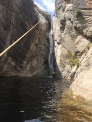
Deer Canyon
| Rating: | |||||||||||||||||||||||||||||||
|---|---|---|---|---|---|---|---|---|---|---|---|---|---|---|---|---|---|---|---|---|---|---|---|---|---|---|---|---|---|---|---|
| | Raps:8-16, max ↨260ft
Red Tape: Shuttle:None Vehicle:Passenger Rock type:Granite | ||||||||||||||||||||||||||||||
| Location: | |||||||||||||||||||||||||||||||
| Condition Reports: | |||||||||||||||||||||||||||||||
| Best season: | Oct
|
||||||||||||||||||||||||||||||
| Regions: | |||||||||||||||||||||||||||||||
Introduction[edit]
ACCESS TO THIS CANYON IS PROHIBITIVE DUE TO THE REQUIRED RIVER CROSSING WHICH HAS BEEN THE SITE OF A CANYONEER FATALITY. The canyon is high quality with big beautiful waterfalls, beautiful deep potholes, slides, jumps, and plenty of excitement. In addition to the river crossing, a heinous approach hike involving a 2600’ gain up steep, grassy, pokey seed cover, sometimes overgrown and mostly hot and exposed to the sun is required. Access necessitates crossing the Middle and South Forks of the Kings River. There is nowhere to cross these rivers above or below the confluence anywhere near Deer Canyon. It could likely be possible (at least in low water years) to wait until the fall when flows on the Kings River have subsided substantially, but at this point Deer Canyon would almost certainly be dry and unexciting.
SWIFTWATER TRAINING AND EXPERIENCE SWIMMING IN CLASS V RAPIDS IS REQUIRED OF ANYONE ATTEMPTING THIS ROUTE. On August 3rd, 2017, ropewiki and the canyoneering community lost not only a truly incredible person, but one of our best, most skilled, and most prolific explorers at the river crossing just below the confluence of the Middle and South Forks. If the thought occurs to you to attempt this canyon, please respect the seriousness of this river crossing, and take the following advice:
- NEVER clip yourself into a rope crossing swift water, except perhaps with the use of a rescue life jacket, and full knowledge of how to use it.
- Be fully prepared to swim whatever is downstream of your crossing if you do not make it to the other side. This means wearing a special-purpose life jacket and having experience swimming in Class V whitewater. There are Class V rapids throughout this section of river.
The safest way to get across this river may be to have an experienced kayaker bring a fast whitewater kayak down to the river to ferry all other party members across individually (with life jackets). But that idea still carries a fair amount of risk.
This is a very long canyon and is not advisable as a day trip. It would be a far better idea to set a base camp at the river and go from there. The canyon can be descended with some long awkward multi-stage rappels off of natural anchors, but a proper descent deserves some bolts installed by experienced canyoneers. With bolts installed, the longest rappel would probably be no more than 120 feet.
Approach[edit]
Yucca Point Trail makes a convenient descent down to the confluence of the Middle and South Forks of the Kings River. This is where you will encounter the problem of getting to the other side.
Note that a rock on the south side of the crossing makes it easy to get out to Deer Canyon, and very difficult to get back.
If you can make it across the river, heading straight up the ridge on the other side seems to be the best way up. Particularly the first 800 feet or so is awful. You'll climb to the top of the ridge at 4800 feet, follow it down to a pass, then make your way down the North East slope to the creek. As this area is growing back in after the Rough Fire in 2015, you will want to carefully scout your approach from Highway 180 before you leave your vehicles. In all likelihood, this is going to get worse as the years go on.
Descent[edit]
The canyon begins quickly with two waterfalls. The second can be rappelled through a narrow crack that makes for a challenging rappel and can grab ropes. It might be better avoided.
Boulder hopping follows and then eventually a really really fun (maybe slightly sketchy) S-turn slide. It looks scary, but seems to work out well.
Further down is a rappel at a large boulder, and then a rappel into a 90 degree left hand bend.
What follows is the first of 3 gorges that can be descended top to bottom through long multi staged rappels. The last one of these is an awesome narrow slot that descends ~5 waterfalls, and will need 260 feet rope to descend in that way. Again, bolts would make this better.
Another big drop follows, then the canyon slacks off into some hiking for a long while, up to the top of a large waterfall you can see from 180. We cut out of the canyon here, quite easily, to the East ridge by traversing over, and followed the ridge down to the river, but it would be worth continuing down if time allows.
Exit[edit]
From the confluence of Deer Creek and the Middle Kings, you will need to cut up on some narrow sketchy deer trails to cut west along the river toward the confluence. You'll likely drop down to the river bed a second time, and soon have to cut onto deer trails for just a bit further to make your way back down to the confluence.
Again you will be faced with the challenge of cross the river, which again, will be substantially more difficult from this side.
Once across, return on the Yucca Point Trail.

