Denny Creek Canyon
| Rating: | |||||||||||||||||||||||||||||||
|---|---|---|---|---|---|---|---|---|---|---|---|---|---|---|---|---|---|---|---|---|---|---|---|---|---|---|---|---|---|---|---|
| | Difficulty:3B III (v3a2 III) Raps:4-5, max ↨150ft
Red Tape:No permit required Shuttle:None Vehicle:Passenger | ||||||||||||||||||||||||||||||
| Location: | |||||||||||||||||||||||||||||||
| Condition Reports: | 13 Jul 2024
"Nice sunny day to enjoy an easy canyon. Flow was very low. Lots of hikers around the upper falls and crowds near the bottom. Parking lot fills up quic |
||||||||||||||||||||||||||||||
| Best season: | Jul-Sep (avg for this region)
|
||||||||||||||||||||||||||||||
| Regions: | |||||||||||||||||||||||||||||||
Introduction[edit]
The water is generally warmer than the South Fork Snoqualmie nearby, and the rappels are all relatively straightforward.
Approach[edit]
Park at the Denny Creek trailhead for handicap only, all others go 150 yards east to the Franklin Falls lot. From the Franklin falls parking, take the trail at the west end over to the Denny Creek parking. Cross the river and a trail starts at the abandoned turn around. Hike up the Denny Creek Trail, going under I90. You'll cross the river DCL to DCR at some slabs - There are logs that you can cross to keep your feet dry. This is your main exit. Keep hiking up, passing Keekwulee Falls until you cross Denny Creek again, this time from DCR to DCL. Here, suit up and head downstream.
Descent[edit]
NOTE: Rappels will likely need to be re-built. Bring webbing, because the day hikers pick up the webbing. Most rappels would be improved if good bolting was utilized.
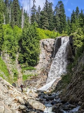
- R1 (Snowshoe Falls): 150', can be done in one or two rappels from choice of trees on either side, can be bypassed DCR (unpleasant). More or less two tiers, with the first tier being 25 m tall. Can rappel the first tier with a 60m rope then downclimb DCR to get through the lower tier, or make another anchor on logs or boulders atop the second tier.
- R2: 20', can be bypassed DCR or down climbed (8/24/21, Snow avalanche field is still 30 feet deep and not passable, start at R3)
- R3: 20', can be bypassed DCR or downclimbed
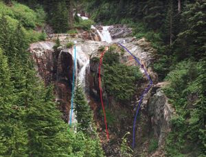
- R4: (Keekwulee Falls):
- Option A (DCL watercourse): short rap into narrows (can be downclimbed at very low fifth class) followed by ~60' rap to bottom, anchor from tree on left out of watercourse or log/boulder in watercourse
- Option B (middle): dry rap from large rock face between the two falls, anchor unknown. Be careful setting an anchor here as people regularly recreate in this area.
- Option C (DCR watercourse): from a bolt & tree on the lip above the large slab leading to the edge. ~180 ft to the pool below. Could be shorter if the conditions allow for down climbing the low angle slopes. You should be able to get visual confirmation of rope length by moving to the far DCR side of the falls.
Downstream of Keekwulee Falls there are a series of smaller waterfalls, all between 20-50ft. Depending on flow & time they can be quick-fire fun, or bypassed.
- R5: From boulder DCR, 20 ft above on shore, takes you down the center. Pool only 4 ft deep
- R6: from rock on sling in DCL crack in flow. Similar in size, but with a curious diagonal ramp across the rock face. Pool only 4 ft deep
- R7: A two stage fall can be done as an on-rope slide when flows permit.
- R8: Low angle cascades
Follow the creek downstream to the slabs you crossed on the hike up.
You have a choice at this point. You can take the trail back to the parking lot or continue downstream another quarter mile or so. The canyon reappears though it is not as deep as upstream. There are little cascades you can downclimb and small pools. When you’ve had enough just exit to your left to rejoin the trail.
Exit[edit]
From the trail crossing, hike down back to the trailhead
Red tape[edit]
Need a Northwest Forest Pass (or America the Beautiful, or other substitute) for parking.
Beta sites[edit]
 CanyoneeringNorthwest.com (archive.org) : Denny Creek
 Super Amazing Map : Denny Creek Canyon
Trip reports and media[edit]
Background[edit]
Waypoints and route provided in map are approximate and unverified. They are estimated based on beta provided from Canyoneeringnorthwest.com and reviewing topo maps and satellite imagery.

