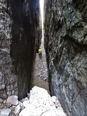
Devil's Tail Canyon
| Rating: | |||||||||||||||||||||||||||||||
|---|---|---|---|---|---|---|---|---|---|---|---|---|---|---|---|---|---|---|---|---|---|---|---|---|---|---|---|---|---|---|---|
| | Difficulty:3A IV (v3a1 IV) Raps:14, max ↨180ft
Red Tape:No permit required Shuttle:Optional 180 min Vehicle:4WD - High Clearance | ||||||||||||||||||||||||||||||
| Location: | |||||||||||||||||||||||||||||||
| Condition Reports: | 1 Mar 2025
"Onsight solo. Approached from Devils Chasm. Chose the left gulley at the split while on approach and did a V1 boulder move to get up into the ramp. T |
||||||||||||||||||||||||||||||
| Best season: | spring, fall, winter
|
||||||||||||||||||||||||||||||
| Regions: | |||||||||||||||||||||||||||||||
Introduction[edit]
A unique, fun, beautiful canyon adventure in the Sierra Anchas with a full day of rappelling and downclimbing challenges.
Approach[edit]
There are 3 different ways to approach Devil's Tail Canyon: from above or from below. The approach from above requires less hiking, and is basically all down hill, but requires a long (2.5 hour, one way) car shuttle to complete. The approach from below does not require the long shuttle, but is a longer hike with an elevation gain of roughly 3000 feet; a good amount of which is off trail and through a steep drainage gully. If approaching the canyon from Cherry Creek Road plan on a minimum of 10 hours.
Devils Chasm Approach[edit]
The approach from Devil's Chasm does not require a shuttle and starts from the bottom. Follow Devils Chasm up past the ruins and to the rim. On the approach, if you are drawn into a chasm on the left and outside the main watercourse, you will be presented with class 5 challenges. To bypass these obstacles, stay in the main watercourse. Follow the Chasm to the top of the rim, then traverse over to the start.
Warning: The bypass for the Class 5 section remains unverified at this time. Be aware that the canyon’s natural terrain tends to funnel you into the Class 5 route.
Approach from below[edit]
From SR188, drive 6.9 miles on SR288 to turn right onto Cherry Creek Road (FR 203). Stay on Cherry Creek Road for about 21.7 miles to the trailhead for Devils Chasm. Cherry Creek Road is well graded dirt until Ellison Ranch, but becomes significantly more rocky and narrow as you approach Devils Chasm. The approach begins on Pueblo Canyon trail, which lies 1.5 miles beyond the Devils Chasm parking area, but some will want to park at the Devils Chasm trailhead and hike the rest of the way for two reasons: #1 there is very little parking in the area where Pueblo Canyon trail splits from FR203 and #2 there is a large boulder in the road along the way that will block the progress of most vehicles. The road is also quite narrow in this area making it difficult to turn around. The hike for Devil's Tail Canyon also ends at the parking for Devil's Chasm, so it makes the most sense to park there.
Hike up the Pueblo Canyon trail for about one mile (2.5 miles from the Devils Chasm trailhead) until you come to a rocky, brushy drainage at a switchback in the trail - leave the trail here to begin the long ascent (gaining about 1400 feet of elevation) up this drainage. The worst of the brush can be avoided by scrambling up on the right (canyon left) side of this drainage, taking advantage of fields of large boulders to ease the climb. There are one or two steep sections of smaller, loose rocks that are a bit more challenging (space out and wear helmets), but other than that the way up the gully isn't as bad as it might look from afar.
Once you top out, head south to hike around the first minor drainage before continuing west through a saddle and up the hill on the other side to locate a light trail that will take you south around Cold Spring Canyon. This trail does not see much use and as a result can be somewhat slow, brushy and difficult to follow in a few sections. After hiking about 1.8 miles on this trail turn left at a small cairn shortly before reaching an old, wooden national forest sign (the main trail goes up towards Aztec Peak) to continue south east towards the drop in for the canyon. We we not able to follow this increasingly faint trail much farther before we gave up on it and just trended south east cross country towards the canyon.
Approach from above[edit]
The approach from above is outlined in the On Rope Canyoneering beta linked below. Note that the road FR487A does not appear on Google Maps. FR487A and part of FR487 are closed (Tonto Closure Alert).
Descent[edit]
Exit[edit]
Red tape[edit]
Beta sites[edit]
 OnRopeCanyoneering.com : Devil's Tail Canyon
Trip reports and media[edit]
Descent down Devil's Tail with Devil's Chasm approach - class 5 route
