Discovery Creek
| Rating: | |||||||||||||||||||||||||||||||
|---|---|---|---|---|---|---|---|---|---|---|---|---|---|---|---|---|---|---|---|---|---|---|---|---|---|---|---|---|---|---|---|
| | Raps:8-10, max ↨125ft
Red Tape:No permit required Shuttle:None Vehicle:High Clearance | ||||||||||||||||||||||||||||||
| Start: | |||||||||||||||||||||||||||||||
| Parking: | |||||||||||||||||||||||||||||||
| Condition Reports: | 12 Jul 2025
"No anchors were found, so possible first descent. Ascended steeps slopes west of the creek to reach a flat-ish area around 2900ft, then dropped into t |
||||||||||||||||||||||||||||||
| Best season: | May-June
|
||||||||||||||||||||||||||||||
| Regions: | |||||||||||||||||||||||||||||||
Introduction[edit]
A nice early season route in the upper end of the Wynoochee River Valley. Discovery requires a bit of work to enter, but is pretty action-packed from start to finish with little-to-no creek walking. Flow becomes quite low by the beginning of summer.
- The checkpoint is where Discovery Creek flows just under the road. Just upsteam is a boulder-jumble. Watershed: 0.35mi^2.
- There is an okay campsite at 47.50108, -123.56242 which can be used for parking.
- Easily combined with the Chikamin Narrows or Clark Creek just down the road.
Approach[edit]
After checking the flow, ascend steep slopes wherever is easiest on the west side of the creek. It's a little easier going if you drift climber's left away from the creek. Slopes are relatively open, without much thick bushwhacking. Drift back towards the creek around 2700ft to find a relatively flat-ish area which can be used for staging and easy entry to the creek. You'll need to ascend higher if you want to run R0.
Descent[edit]
The creek is full of boulder jumbles. A number of downclimbs are not described in the beta. You may end out doing more or less rappels based on comfort. The lower canyon had a bunch of woody debris in summer 2025.
- R0: 45ft bonus waterfall above the original drop-in point.
- R1: 15ft tree root DCR.
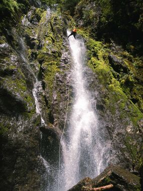
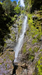
- R2: Discovery Falls - 125ft from tree DCL. The creek drops down a V-shaped groove/crack into a pocket. Below this, the creek bends slightly DCR and then goes vertical. There may be some foot entrapment potential on this pitch. In high flow, it may be better to rappel the DCR side of the falls.
- R3: 15ft from log DCL.
- R4: 20ft nuisance rappel from a tree high DCR to avoid a couple of short drops, both with logs in them.
- R5: 50ft from single bolt DCR. There is a small siphon just before the anchor station.
- R6: 25ft from log DCL.
- R7: 20ft nuisance rappel down two short awkward drops from log mid-creek.
- R8: 45ft from rock pinch DCL.
- Bypass short drop via loose gully DCR.
- R9: 25ft rappel through logjam from rootball creek center.
Exit[edit]
After the last rappel, the canyon opens and there's an easy exit DCL. Just walk down to the road. It's possible to continue down the creek, but there's just a couple of boulder jumbles remaining.
Red tape[edit]
The northern end of Wynoochee Valley is closed seasonally from Oct 1 through April 30 and is gated at approximately 47.44722, -123.55027 on FR 2270. (Oddly in 2023, the season was extended until November 1.) Access is still legal on foot or by mountain bike.
Beta sites[edit]
Trip reports and media[edit]
Background[edit]
First descended by Wade Hewitt, Ashley Driscoll, Eric Rutz, and Kevin Clark in July 2025.
Future Explorations[edit]
It might be possible to shuttle further up FR2270 to 47.49811, -123.58111 and hike the old road grade around the valley to drop into Discovery from above (1.6mi, 460ft gain). This might be an easier way to visit some additional drops higher up on the creek.

