Downclimbers' Delight Canyon
| Rating: | |||||||||||||||||||||||||||||||
|---|---|---|---|---|---|---|---|---|---|---|---|---|---|---|---|---|---|---|---|---|---|---|---|---|---|---|---|---|---|---|---|
| | Difficulty:3A I (v2a1 I) Raps:0-2, max ↨25ft
Red Tape:No permit required Shuttle:None Vehicle:4WD - High Clearance | ||||||||||||||||||||||||||||||
| Location: | |||||||||||||||||||||||||||||||
| Condition Reports: | 22 Nov 2024
"Descended to river and climbed back out upcanyon. Left a rope as a handline wrapped on a rock for one of the drops in the middle, it was approximately |
||||||||||||||||||||||||||||||
| Best season: | winter
|
||||||||||||||||||||||||||||||
| Regions: | |||||||||||||||||||||||||||||||
Introduction[edit]
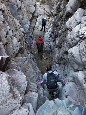
A short, geologically interesting route to the Salt River with several - as you may have teased out from the name - downclimbs of varying difficulty. Some will be comfortable climbing down the drops in this canyon unaided, others will not - bring a short rope (50 feet) to be prepared for either option.
From Globe, AZ drive 16.3 miles to turn left onto FR303 (also Haystack Butte Road and well graded dirt) directly across from Jones Water Campground. After 4.5 miles turn left to stay on FR303 and drive another 3.6 miles (8.1 total) to turn right onto FR645. Follow this last stretch of dirt road for 3.3 miles to park (11.4 total miles) by a corral right by the drainage of the canyon. Forest Road 645 becomes more steep and rutted as you go - a high clearance 4x4 vehicle is highly recommended. There are two cattle gates along the way, be sure to close them behind you.
If looking for camping in the area, there isn't much - we stayed at a small site just big enough to squeeze in three cars at the junction of FR303 and FR645. There are also a few options earlier in the drive off of FR303. Jones Water Campground is also a good option that is free and has composting toilets, tables and fire pits, but is right by the highway.
Approach[edit]
From the parking area simply head right down into the drainage of the canyon.
Descent[edit]
The canyon cuts through an interesting, tilted layer of colorful metamorphic rock making for some unique scenery. The downclimbs begin soon after entering the canyon and become more difficult and exposed the farther down canyon you go; the tallest of which is probably around 20 feet tall - each group will need to assess the drops and decide for themselves whether to use a rope to aid in the descent or not. The last drop shortly before reaching the river is maybe the trickiest as you need to traverse around to find the easiest line, but this drop also looks like it may be able to be bypassed all together on the right.
Exit[edit]
One option for the exit is to go right back up canyon depending on your groups comfort with the vertical obstacles. A second option is to hike along the Salt River to the next, more minor drainage to the south - the hike along the river is both scenic and adventurous and is a worthy hike in itself. A few minor drainages and thick bamboo stands must be negotiated along the way, culminating in a tricky section at the last stretch of cliff that ends in a 15 foot drop that can be downclimbed or a rope can be used for a handline or rappel from a small rock horn above the drop. Depending on river levels this last section of cliff can be hiked around in the river itself, but beware of the deep mud along the shore here. On our visit the water was only a few inches deep, but we immediately sunk thigh-deep in the mud and had to use the wall to pull ourselves out and through this short section. After negotiating the cliff the going is much more straight forward as you hike up through the first drainage on your left back to the parking area. The exit canyon is brushy in a few spots, hike around on the slopes to avoid the worst brush where you see fit. Hike up the drainage; then left where it splits to cross over the saddle at the top, then back down to the road and the parking area, negotiating one barbed wire fence along the way.
Red tape[edit]
Beta sites[edit]
 Super Amazing Map : Downclimbers' Delight Canyon
