Drummond Waterholes

From ropewiki.com
Jump to: navigation, search
Drummond Waterholes Canyoneering Canyoning Caving
 For other features with similar names, see Waterholes (disambiguation)
Rating:
Log in to rateLog in to rateLog in to rateLog in to rateLog in to rate 3.0 (1 rating)

Drummond Waterholes Banner.jpg

Difficulty:3B II (v3a2 I)
Raps:‌1-3, max ↨130ft
Metric
Overall:4-6h ⟷7mi
Approach:10-30min
Descent:1.5-3h
Exit:2-4h
Red Tape:No permit required
Shuttle:
Vehicle:4WD - High Clearance
Location:
Condition Reports:

(log in to submit report)
Weather:
Best season:
April-May or October
winterspringsummerfall
DecJanFebMarAprMayJunJulAugSepOctNov
Regions:


Welcome! Canyons in the Pacific Northwest can be different from those you might be used to. Be ready for unlinked bolts, retrievable traverse lines, and challenging aquatic environments. For more on local practices, and the best way to get started in the region, check out the WCC Safety page.
  • Unlinked Bolts - groups should be comfortable rigging unlinked bolts, either temporarily linking them for all but the last person, or using a passive redundancy method. Most importantly, if you find two bolts side by side that are unlinked, do not add webbing to them. Linking bolts designed to be unlinked will likely cause damage during seasonal floods.
  • Traverse Lines - many canyons are rigged to allow traverse line access to an exposed anchor station. This should be done using self-belay or team belay techniques. Do not leave fixed lines in the canyons.
  • Challenging Environments - the highly aquatic nature of PNW canyons can surprise many. Cold temperatures, slippery rocks, loud waterfalls, and strong currents all lead to unexpected problems. Do not underestimate the need for strong team work and technical proficiency. Belays are frequently not possible. Unattended gear will sink or float away. Sliding and jumping is the cause of most major injuries, so it's critical to effectively communicating water depth & submerged hazards.

Introduction[edit]

Drummond Waterholes can be done as a loop with another unnamed canyon to the South we could call 5-Bar Canyon since it's right next to 5-Bar road. Some of the road to get here is quite gnarly. Bring a big rig such as a Jeep, Tundra or the like (No, a Subaru will not do unless you've lifted it like four inches and put light truck tires on it!). The pay to play ratio is relatively high for this canyon. Adding some of the other amazing things to do in this area is highly suggested if you're headed out this way.

Approach[edit]

Descent[edit]

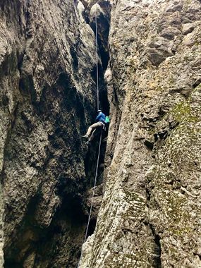
There are at least two rappels into pools in the upper narrows if you want to do them. They can be avoided if you choose. These drops would be fun if you did this loop in the spring, the canyon is flowing and have wetsuits. This canyon is a 3A in the fall and assuredly a 3B or even 3C depending on how you get it in the spring. We saw signs of it sometimes flowing quite high. Make sure to bring highly protective clothing. There is a fair amount of sharp bushes that will snag wetsuits or really anything other than thick carhartt type pants. The mandatory big rappel in the lower section can be done from three different places. We chose the RDC option and still think that is the best option. It is around 120 to 130 feet and comes after dropping into a little cave like section of the canyon. This rappel is mostly free hanging. Be careful not to get your rope stuck in some of the rocks in the last 15ft of the rappel. We had to climb back up that little bit and unstick it even though it fell what appeared to be cleanly.

Exit[edit]

Follow up the Owyhee River 1.5 miles until you get to where 5-Bar Canyon comes in. Another option is to skip the second canyon and hike up the obvious ATV track that comes down to the river and links into 5-Bar road at the rim. If choosing to do the second canyon, there is a wall that cannot be scaled a little ways in. Turn around and head up the first obvious opening to the North. We dropped back into the canyon just above this section and explored the rest of the canyon. It was worth the time in my opinion. There were a couple potholes, the likes of I've never seen in the Owyhees before.
Red tape[edit]

Beta sites[edit]

Trip reports and media[edit]

https://photos.google.com/share/AF1QipPw6rj0sP0I9vn_w4LDUjxcarnYVXUQYsES4Ce1zGhAken5l-5lRy85wZEDfmVRPQ?key=OHpTUzItTTZtQXNFSjBUUV9WbFFueG9jSFVUQk53

Background[edit]

Credits

Information provided by automated processes. KML map by (unknown). Main photo by (unknown). Authors are listed in chronological order.

In all habitats live animals and plants that deserve respect, please minimize impact on the environment and observe the local ethics. Canyoneering, Canyoning, Caving and other activities described in this site are inherently dangerous. Reliance on the information contained on this site is solely at your own risk. There is no warranty as to accuracy, timeliness or completeness of the information provided on this site. The site administrators and all the contributing authors expressly disclaim any and all liability for any loss or injury caused, in whole or in part, by its actions, omissions, or negligence in procuring, compiling or providing information through this site, including without limitation, liability with respect to any use of the information contained herein. If you notice any omission or mistakes, please contribute your knowledge (more information).

Retrieved from "https://ropewiki.com/index.php?title=Drummond_Waterholes&oldid=214403"