Dry Hollow
| Rating: | |||||||||||||||||||||||||||||||
|---|---|---|---|---|---|---|---|---|---|---|---|---|---|---|---|---|---|---|---|---|---|---|---|---|---|---|---|---|---|---|---|
| | Difficulty:3A I PG (v4a1 I) Raps:1, max ↨65ft
Red Tape: Shuttle: Vehicle:Passenger | ||||||||||||||||||||||||||||||
| Location: | |||||||||||||||||||||||||||||||
| Condition Reports: | 2 Dec 2018
"A nice short canyon with roadside access. With only one pitch at the start, only minutes from the road, you can pull your rope after you exit. If you |
||||||||||||||||||||||||||||||
| Best season: | Any time
|
||||||||||||||||||||||||||||||
| Regions: | |||||||||||||||||||||||||||||||
Introduction[edit]
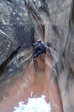
A nice short canyon with roadside access. With only one pitch at the start, only minutes from the road, you can pull your rope after you exit. If you use a tensionless hitch off one of the trees you'll want a 35m rope, otherwise the pitch is around 25m - though you can downclimb the last couple of metres. The canyon is quite narrow with a 'V' cross section pretty much the whole way. Some high stemming is required and you wouldn't want to fall. There were a few shallow pools, all easily avoidable except at the end which required a little more effort. The exit posed the biggest challenge for us. There had been 10cm of fresh snow overnight making travelling on the slickrock too dangerous. We ended up climbing the slot to the top before contouring around. This involved one tricky offwidth crack climb.
Approach[edit]
Descent[edit]
Entry rappel off stout Juniper requires 75 feet of rope if tying off rope. This is a nice fluted rappel. The slot is 300 feet in length and requires several short, easy downclimbs. Optional high-stemming is available but passage on the bottom is possible.
Exit[edit]
After the narrow slot ends there is a crack on the right. Go past this by 100 feet. The next slot is the exit. When dry climbing up the prow is fairly easy with one or two Class 3 climbing moves. If wet, take the crack which has some annoying foliage to get by.
Red tape[edit]
Beta sites[edit]
 CanyonCollective.com : Dry Hollow
