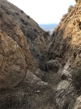
Dual Canyon
| Rating: | |||||||||||||||||||||||||||||||
|---|---|---|---|---|---|---|---|---|---|---|---|---|---|---|---|---|---|---|---|---|---|---|---|---|---|---|---|---|---|---|---|
| | Difficulty:4A III (v4a1 III) Raps:10+, max ↨120ft
Red Tape:No permit required Shuttle:Optional 70 min Vehicle:High Clearance | ||||||||||||||||||||||||||||||
| Location: | |||||||||||||||||||||||||||||||
| Condition Reports: | 21 Dec 2024
"Parked at the flight park, signed their waiver, and hiked up their trail to a fire road and the drop-in in 1:45. The canyon had a lot of brush but com |
||||||||||||||||||||||||||||||
| Best season: | Anytime, HOT in Summer
|
||||||||||||||||||||||||||||||
| Regions: | |||||||||||||||||||||||||||||||
Introduction[edit]
This is a rugged canyon that drops steeply in a short distance. For this reason, you will encounter an obstacle almost constantly, offering many rappels and easy to moderate down climbs. The amount of each will depend on comfort level of down climbing, so be ready do to more than 10 rappels. The name Dual comes from the dual approach options, you either descent the main fork on the west side, or the one on the east. Our group descended both the same day, splitting in the beginning and meeting at the confluence. There was no vegetation at the time of descending, not anything substantial anyways, so skills are required to rebuild or make cairn anchors at every drop. Note that some area lack suitable rocks, so one must carry or roll down from further upstream.
Approach[edit]
This report describes the shuttle approach which takes about 1.5 hours each way. The alternate is to hike up one of the ridges on either side of the canyon but this is not recommended. It is very steep, loose, crumbly, and won't save you any time. Park your exit vehicle at the mouth of the canyon on Soboba Rd , then head west on that road, make a right on Gilman Sprinds road and another right on HWY 79 and head north until to reach I 10. Take the I 10 east and exit on 8th. Make a right on the exit onto 8th and a quick left on Lincoln. A last right on San Gorgonio Ave/HWY 243 and drive up the mountain for about 7.8 miles. Make a right on Poppet Flat Rd and immediately on the right you'll see the beginning of the dirt road. It is 9.5 miles to the top, on a easy dirt road. Some small ruts were present but nothing that would required 4WD. There is a small turn out to park, from there you immediately drop in. You can see the semi flat wash below.
Descent[edit]
Once at the wash, you can opt to split the group or pick a route. The route on the west offers a lot down climbing, 2-3 rappels one being 120'. The east route offers more rappels but not as long. The saddle that separates the two drainages is a quick 5 minute detour. The following will be on just the west route.
Right after the flat wash there will be some down climbs, 2 or 3 of 20' each. Continue hiking for another 10 minutes with more down climbs and you will reach the first rappel.
- R1: 30 from cairn in watercourse
A few hundred feet later there's a 30' down climb LDC and will follow several more down climbs for about 20 min until you reach the first large rappel. The walls narrow here as the canyon makes a sharp right turn.
- R2: 125 from cairn in watercourse. Rock on this drop is jagged and loose, mind rockfall.
A short walk and you'll reach the confluence coming from the left, you will see the last 50' drop from a series of ledges on that route. One down climb after that and you will reach the next rappel.
- R3: 30' from cairn in watercourse down a chute like drop.
- R4: 90' vertical drop
- R5: 100'
- R6: 20'
- R7: 3 stage rappel; 25', 35' 60'
- R8: 50'
- R9: 30'
- R10: 120' 3 stage rappel; 15', 15', 30'
Exit[edit]
After the 3 stage, you can remove your harness and make the quick 15 min hike back to your vehicle.
Red tape[edit]
No access issues noticed. The forest road lies on forest land and BLM.
Beta sites[edit]
Trip reports and media[edit]
Background[edit]
First documented descent by Christian, Casey, Ryan and Kenny. No evidence of anchors or people noticed. Name came from our dual approach, as looking on Google Earth showed potential on both drainages. Instead of making two separate trips, we opted to split and document both approaches.
