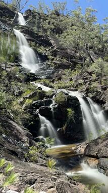
Duffer Falls
| Rating: | |||||||||||||||||||||||||||||||
|---|---|---|---|---|---|---|---|---|---|---|---|---|---|---|---|---|---|---|---|---|---|---|---|---|---|---|---|---|---|---|---|
| | Raps:4, max ↨148ft
Red Tape: Shuttle:None Rock type:granite | ||||||||||||||||||||||||||||||
| Start: | |||||||||||||||||||||||||||||||
| Parking: | |||||||||||||||||||||||||||||||
| Condition Reports: | |||||||||||||||||||||||||||||||
| Best season: | Oct-Apr (avg for this region)
|
||||||||||||||||||||||||||||||
| Regions: | |||||||||||||||||||||||||||||||
Introduction[edit]
Something to do when you're not doing Dandahra.
The falls flow from Gibraltar Range NP into Boundary Creek, on the western boundary with Washpool NP. Boundary creek flows north along the Demon fault.
You can choose to go in or out of the flow, probably under reasonably high conditions, when Dandahra is flooded.
The falls about 300m down from the bridge at -29.52166, 152.24898 also looked interesting.
Approach[edit]
Park at Boundary Falls campground and walk about 3km along NW trail, then turnoff 500m to the top of the falls.
Descent[edit]
Scramble or abseil the first drop at the end of the trail, to a point where you can see to the base of the falls in the valley, then :
P1 - 45m - tape on tree CR
P2 - 45m - tape on log CC
P3 - 40m - tape on tree CR
P4 - 30m - tape on tree CL
Exit[edit]
Exit up Boundary creek below the cliffs in a sweet rockhop of about 1km to a fork at the low end of a ridge.
Go up the ridge to find the NW trail and back to the cars.
Red tape[edit]
The Gibraltar Range management plan does suggest that permits are required, but that they are happy with a low level of activity
