Dug Hollow
| Rating: | |||||||||||||||||||||||||||||||
|---|---|---|---|---|---|---|---|---|---|---|---|---|---|---|---|---|---|---|---|---|---|---|---|---|---|---|---|---|---|---|---|
| | Difficulty:3B III (v3a2 III) Raps:1, max ↨50ft
Red Tape:No permit required Shuttle:None Vehicle:Passenger | ||||||||||||||||||||||||||||||
| Start: | |||||||||||||||||||||||||||||||
| Parking: | |||||||||||||||||||||||||||||||
| Condition Reports: | |||||||||||||||||||||||||||||||
| Best season: | "Autumn to Spring"
|
||||||||||||||||||||||||||||||
| Regions: | |||||||||||||||||||||||||||||||
Introduction[edit]
This hollow is at its best with flowing water, which makes the hike out a challenge. We completed this hike during May while water was still flowing. Arkansan hollows are basically jungles in May, but they are much more beautiful than during the winter when there are no leaves. Be prepared to wade through dense thickets of poison ivy if you complete the hollow during the summer.
Approach[edit]
Park at the Cave Mountain Church (35.904, -93.4556). Park near the edge of the parking lot in case others need access to the church and graveyard.
Descent[edit]
Walk north on Cave Mountain road, cross to the east side, and enter the woods where the Forest Service property abuts the road. Consult the map and look for the forest service boundary marker to make sure that you don't trespass. There are numerous "No Trespassing" signs posted in the woods. Head generally east towards point 35°54'22.78"N, 93°26'18.12"W, which will put you in a tributary hollow and just upstream from a waterfall. To get there, though, you’ll have to contour around several small tributaries that feed into Dug Hollow. If water is flowing in any of the tributaries, then plan for a wet rappel.
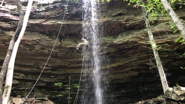
Once you’re in the tributary hollow, head downstream toward Dug Hollow and you’ll quickly come to a patio above a ~50’ waterfall in the Upper Bloyd Formation. There are no large trees adjacent to the waterflow to build an anchor from and that would allow for a clean pull. So, we used about 100’ of webbing to build a three-ring retrievable anchor from a cedar set back from the edge about 30’. Our 200’ rope still easily reached the ground double stranded. This allowed us to rappel directly in the water line of the fall. The upper cliff is vertical for about 10’ but quickly becomes undercut so that most of the rappel is free hanging. You’ll land in a jumble of slick boulders at the base of the fall. Retrieve the rope and anchor. You can remove your technical gear because there is nothing requiring a rope downstream. Once over the fall, proceed downstream and under a giant house-sized boulder to reach the confluence with Dug Hollow.
Head downstream from the junction of the tributary and main branch. We had some strict time constraints and couldn’t reach the Buffalo before we had to turn around. Below the confluence, there are many large boulders and ledges that the creek flows over and around. It’s beautiful, but slow going. The hollow is too narrow for a use trail to exist on either side.
Exit[edit]
When you’re ready, head back upstream and stay in the main stem of Dug Hollow. Once you pass the tributary you descended earlier, you’ll quickly encounter the same layer of the Bloyd Formation as you continue upstream. With flowing water, this section is strenuous to ascend. In quick succession, you’ll encounter three waterfalls, each in 10-15’ range. There’s no obvious way to skirt around the first two. To ascend the first one requires a fairly dicey move aided by a handhold on a root. The second is a bit easier, but both can be challenging because they are wet, and you are probably carrying a heavy pack. The third fall can be bypassed on creek right (the left side if you’re looking upstream). This section is stunningly beautiful. Once above the falls, the walking gets easier and, if you’re lucky, you can pick up a game/use trail on creek left. Keep an eye on the GPS and don’t head up the wrong tributary as you make your way back to your car at Cave Mountain Church.
Red tape[edit]
Beta sites[edit]
Trip reports and media[edit]
05/28/2022: The weather was a perfect sunny May day, with the afternoon high in the upper 70s. We got an early start on the hike, so it was never too hot. We hiked this hollow on a Saturday; a few inches of rain had fallen on the preceding Tuesday through Thursday and the week before we hiked had been unseasonably cool, with highs only in the upper 50s and lower 60s. As a result, all of the tributaries to Dug were flowing, but not at a torrential level. The waterfall rappel in the tributary hollow is one of the best around. Dug hollow is quite a gem. The waterfall is not the highest in the area, but it's hard to beat the combination of the tall waterfall and intimate hollow below. I would rate Dug Hollow as one of the best in the Buffalo River area.
