Eagle Hollow
| Rating: | |||||||||||||||||||||||||||||||
|---|---|---|---|---|---|---|---|---|---|---|---|---|---|---|---|---|---|---|---|---|---|---|---|---|---|---|---|---|---|---|---|
| | Difficulty:2A II (v1a1 II) Raps:0
Red Tape:No permit required Shuttle:None Vehicle:Passenger | ||||||||||||||||||||||||||||||
| Location: | |||||||||||||||||||||||||||||||
| Condition Reports: | |||||||||||||||||||||||||||||||
| Best season: | fall
|
||||||||||||||||||||||||||||||
| Regions: | |||||||||||||||||||||||||||||||
Introduction[edit]
A short, easy, non-technical hike to explore a minor canyon that is tributary to the Verde River near the small town of Rio Verde. While the narrows are not very dramatic and there are no technical challenges (except one short optional up/down climb) Eagle Hollow is still a fairly interesting day with abundant wildlife at the wild and scenic Verde River.
How you get there depends a bit on what part of the valley you are coming from, basically navigate to Rio Verde, from Rio Verde Dr go north on Needle Rock Road a short distance then turn right onto Box Bar Rd which becomes dirt for the last 1/2 mile. Follow this road to its obvious end after a grand total of one mile and park at the trailhead.
Approach[edit]
From the east end of the parking area, head through the fence to hike east, then south east on the complex system of roads, washes and cattle trails that will get you to the river after about one mile. While the river is nice here, it is also frequented by both cattle and horses, giving it a bit of a barn yard feel (e.g. smell). The best place to ford the river seems to be slightly up river from an island that splits the river in two, where the water is at its widest point. At this spot the water was only a bit more than knee deep, though you still should use care not to loose your footing as you could go for a bit of an unwanted ride. I crossed at a point farther south and almost directly across from the mouth of the canyon where the water was more than waist deep and moving very swiftly. It was clear at this point that a loss of footing would carry you off down river where it might take some time (and considerable effort) to recover to shore. No matter where you cross make your way south to the gravel wash where the canyon meets the river and head up the wash.
All waterways vary in flow rates to some degree, carefully evaluate the flow of the river before attempting to ford it. I suspect there are times when crossing the Verde River here will be totally inconsequential, and times when it will down right dangerous.
Descent[edit]
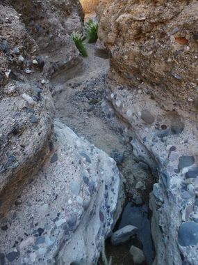
The easiest way to explore the canyon is by hiking directly up it. The narrows are generally fairly shallow but are interesting, water sculpted conglomerate rock and the canyon is mostly free of brush making for easy hiking. A few shallow pools may be found in the narrows and there is one vertical obstacle at a chock stone a ways up the canyon that is a moderately difficult, but short climb. The canyon can be explored for a little under 2 miles, be sure to turn back before reaching the boundary with the Fort McDowell Indian Reservation (shown on the topo map).
Exit[edit]
Return the way you came - a GPS may be helpful to navigate the complex web of roads and washes in the area - I got a bit off track on the return hike and was glad to have mine.
Red tape[edit]
The east side of the Verde River is closed to all traffic of any kind from December 1st through June 30th to protect the eagles nesting in the area. Also be careful not to cross onto the Fort McDowell Indian Reservation just slightly to the south of Eagle Hollow - the boundary is clearly marked on the topographical maps.
