El Laberinto
| Rating: | |||||||||||||||||||||||||||||||
|---|---|---|---|---|---|---|---|---|---|---|---|---|---|---|---|---|---|---|---|---|---|---|---|---|---|---|---|---|---|---|---|
| | Difficulty:3B I (v3a2 I) Raps:3-5, max ↨197ft
Red Tape: Shuttle:None Vehicle:Passenger Rock type:Limestone | ||||||||||||||||||||||||||||||
| Location: | |||||||||||||||||||||||||||||||
| Condition Reports: | 7 Mar 2019
"Party : Emmanuel Sosa, Gerardo Lira and Felix Ossig-Bonanno. One way or another I was returning to the mountains. I was hoping to do another trip |
||||||||||||||||||||||||||||||
| Best season: | Anytime
|
||||||||||||||||||||||||||||||
| Regions: | |||||||||||||||||||||||||||||||
Introduction[edit]
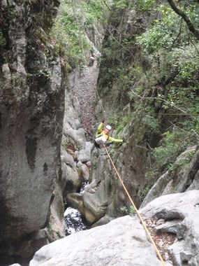
A short but fun canyon that has an optional steel cable that goes over a dark black pool of water to avoid swimming. Normally a dry activity if you avoid this pool.
Approach[edit]
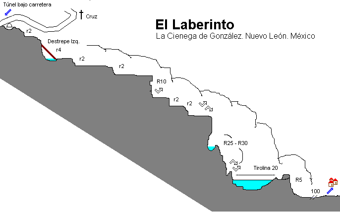
From Santiago take the road that leads to the Cola de Caballo, pass it and keep driving into the mountains. Shortly before reaching the town of La Cienega de Gonzalez, the road turns sharp right and goes up and over a a ridge. At the top of this is a well-visible cross. Where the road goes up, the dry streambed crosses under the road through a metal culvert. You can drop down into the canyon here and walk through the tunnel.
If you are walking the shuttle, it is advisable to park at the bottom, where there are cabins and people around. The parking spot at the top is isolated and might lend itself to break-ins.
Descent[edit]
Start from the metal culvert that goes under the road and walk through the tunnel. There are two short pitches no more than 10m that are easily downclimbed. Alternatively, there are anchors near the cross at the top to rap directly into the canyon and skip this first part.
After starting in the canyon, you'll quickly reach a 20m rappel. Then comes the Laberinto, the narrowest constriction. There is a black pool at its bottom. You can drop two pitches here and swim the pool, or avoid it by utilizing the steel cable for a guided rap. Do not zip-line this, as the speed into the end would result in possibly fatal injuries.
The cable finishes with a stopper, and your legs will be dangling a couple meters off the ground. Be prepared with a foot loop that you can hook onto the cable, to unload yourself from the pulley and get off. Then you can reach out with your legs to the wall and climb down. Note that using pulleys with aluminum rollers (such as a micro-traxion or similar lightweight pulleys) will damage the surface of the pulley from the steel cable, possibly causing burrs that will need to be polished off later. The cable is 65m, and is a skinny 3/8" braided steel.
It's then a short walk to the road.
Exit[edit]
Red tape[edit]
The hike out will go through a summer camp area. They did not say anything to use in 2022 when we walked by about paying them an access fee or anything.
Beta sites[edit]
 Chris Brennen's Adventure Hikes (Southwest) : El Laberinto
 Explore Pangea : El Laberinto Canyon
 Wikiloc.com : Cañón del Laberinto
Trip reports and media[edit]
 Randi Poer on Canyon Tales : El Laberinto

