El Salto
| Rating: | |||||||||||||||||||||||||||||||
|---|---|---|---|---|---|---|---|---|---|---|---|---|---|---|---|---|---|---|---|---|---|---|---|---|---|---|---|---|---|---|---|
| | Difficulty:3A I (v3a1 I) Raps:2, max ↨150ft
Red Tape: Shuttle: | ||||||||||||||||||||||||||||||
| Location: | |||||||||||||||||||||||||||||||
| Condition Reports: | 7 Mar 2019
"Party : Emmanuel Sosa, Gerardo Lira and Felix Ossig-Bonanno. One way or another I was returning to the mountains. I was hoping to do another trip |
||||||||||||||||||||||||||||||
| Best season: | Anytime
|
||||||||||||||||||||||||||||||
| Regions: | |||||||||||||||||||||||||||||||
Introduction[edit]
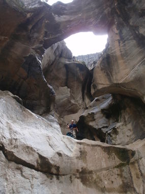
A very short canyon, essentially two rappels right after each other, often used for training canyoneers in the Monterrey area. The first rappel is scenic, going under a large rock arch. The second rappel can have a pool at the bottom with deep mud to walk through, or could be completely dry.
It is located very close to El Laberinto and is often done on the same day, as both are quite short. It is also located in the middle of a large rock climbing area that has more than 300 climbing routes established (see Beta sites for more info). You will likely have a lot of Polaris RZR and ATV traffic driving by on the approach/exit hike, as it is a popular destination with people renting these machines in Santiago (maybe you!)
Approach[edit]
From the parking area, walk down the rocky road that follows the large wash going between the huge canyon walls. You'll pass the first climbing walls on the left. After about 20 min the road will start to head uphill on the right -- here get off it and go through a short boulder maze to the top of the first drop. The road that went up on the right will be your exit hike back.
(Note: do not follow the current Wikiloc track -- the track is off and shows the canyon up on the cliffs to the right)
Descent[edit]
Exit[edit]
Be sure to note the pictographs on the rock on the hike back up to the top -- these are more than 3000 years old according to INAH, who have put a fence around them.
Red tape[edit]
Beta sites[edit]
 Explore Pangea : El Salto Canyon
 Wikiloc.com : Rapel en cascada del Salto
Rock climbing info:
