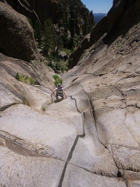
Elder Canyon
| Rating: | |||||||||||||||||||||||||||||||
|---|---|---|---|---|---|---|---|---|---|---|---|---|---|---|---|---|---|---|---|---|---|---|---|---|---|---|---|---|---|---|---|
| | Difficulty:3A III (v3a1 III) Raps:1-2, max ↨100ft
Red Tape:No permit required Shuttle:None Vehicle:Passenger | ||||||||||||||||||||||||||||||
| Location: | |||||||||||||||||||||||||||||||
| Condition Reports: | 15 Jan 2025
"Some frozen shallow pools, otherwise dry. Rock is incredibly slick along the watercourse. Time reflects a loop, taking the slab route to the Elden sum |
||||||||||||||||||||||||||||||
| Best season: | all year, BEST in May;Jun;Aug;Sep
|
||||||||||||||||||||||||||||||
| Regions: | |||||||||||||||||||||||||||||||
Introduction[edit]
A decent urban canyoneering route with a short, fun section of basalt narrows in Flagstaff, AZ. Trash and graffiti are not nearly as bad as you might expect from an urban canyon this close to town - you may not even notice the little that is present along the way.
The hike begins and ends at the Mt Elden Lookout Trail parking area located on the north side of SR89 .8 mile northeast of the junction of SR89 and I40.
The sneak route halves the time necessary to do this canyon (2-4 hrs).
Approach[edit]
From the trailhead, follow signs for Elden Lookout trail as it climbs up through the forest to the mountain top. The trail becomes more steep the farther you go, but still climbs fairly gradually and is well maintained and easy to follow. The trail eventually takes you to a complex of antennas at the top - turn right on the road and follow it around to the south, then down the hill as it switches back to the north again. Shortly after passing through the gate at the bottom, begin making your way into the steep, grassy drainage on your left to begin your descent into the canyon.
Stairmaster sneak: Park along the street at the Lugano Way cul de sac and enter trail, staying left at the big interpretive sign. Bear left at sign announcing elden grave site and look for an easy way up on the rocks to your right before entering the canyon mouth. Work your way right and upslope until you reach a nice open section of slabs with great views over Flagstaff. Go straight upslope, staying in the open areas till it starts to get brushy again. Make your way northwest, looking for the path of least resistance till you hit the edge of the cliffs bounding the LDC side of Elder. You can rap down into the canyon here or continue a bit further until the cliffs end and you can walk down into the drainage. This will drop you above the 2 slickrock sections and the rappel.
Descent[edit]
The upper part of the canyon is steep, but open and easy to make you way down. The drainage deepens as you head down with no significant obstacles until you reach the narrows roughly half way down the canyon.
Once you reach slickrock you will find numerous dry slides and short, easy downclimbs. One drop of about 10 feet can be downclimbed (though you may just fall the last three or four feet) or rappelled from a tree RDC.
Not far after this first minor drop you will encounter the one mandatory rappel in the canyon. The rappel can be done through the chute directly in the watercourse if you can find a suitable anchor at the top of the chute, or from two bolts and hangers on the left. Currently, a large, not entirely stable chockstone is wedged at the top of the chute. Though it would be fun to rap down that way, the bolts LDC make for a much easier pull. Webbing is installed on two of these and the drop is about 105' from rapide to the ground. You can get down with maybe 85-90' of rap line by getting off on a comfortably large ledge and downclimbing the rest of the way.
Exit[edit]
Continuing down canyon you will begin to pick up a climbers' trail that will take you through the drainage that will meet up with the Pipeline Trail that you can take back to the trailhead.
Follow the Pipeline Trail southeast past an interesting grave site to turn left on an old road to stay on the trail. After hiking the road about .5 mile, turn left to depart from the road and stay on the trail as it re-enters the forest. From here the trail skirts between the bottom of the mountain on your left and a residential area on your right for about another .5 mile to eventually rejoin the Elden Lookout Trail. Turn right onto Elden Lookout Trail and follow it the remaining .5 mile back to the trailhead.
If you're parked on Lugano Way, continue straight south from the climber's trail that angles LDC out of the bouldery lower section, crossing pipeline and looking for the interpretive sign that you encountered upon entering the trail.
Red tape[edit]
Beta sites[edit]
 HikeArizona.com : Elder Canyon
 CanyonChronicles.com : Elder Canyon
