Elkhorn Mountain Creek
| Rating: | |||||||||||||||||||||||||||||||
|---|---|---|---|---|---|---|---|---|---|---|---|---|---|---|---|---|---|---|---|---|---|---|---|---|---|---|---|---|---|---|---|
| | Raps:9-12, max ↨175ft
Red Tape:Closed to entry Shuttle:Required Vehicle:High Clearance | ||||||||||||||||||||||||||||||
| Location: | |||||||||||||||||||||||||||||||
| Condition Reports: | 6 May 2017
"extracts from Facebook posts, click link for full details (privacy restrictions may apply). " After scouting the Elkhorn Mtn Falls drainage a mont |
||||||||||||||||||||||||||||||
| Best season: | Apr-July, BEST in May-June
|
||||||||||||||||||||||||||||||
| Regions: | |||||||||||||||||||||||||||||||
Introduction[edit]
Current Status: Closed. This creek was overrun by the Beachie/Santiam Fire in Sept 2020 and has been closed. Please check on local closures before planning a trip to this area. When the area eventually reopens, use extreme caution when descending the creek. Between landslides, fallen trees, and loose rocks, this area may be unstable and dangerous for years to come. The canyon may have changed dramatically. Do not rely on the beta below being accurate.
Elkhorn Mountain Creek is a tributary of the Little North Santiam River draining the northern face of Elkhorn Mountain and sports one huge multi-pitch rappel at over 200ft. The creek has particularly nice access when the road is melted out as one can drive pretty much all the way up to the top. Bushwhacking is minimal. Get an early start as it can be a full day event.
- The upper road is not plowed in early season. On the first descent, we drove up as far as we can and hiked ~1mi in snow to the top.
- As the creek largely originates from snowpack it can be Very Cold in the early season.
- Water probably drops out on the creek fairly quickly after the snow melts. Best to visit in the early season.
Lower Trailhead[edit]
From the popular Three Pools area, follow FR2207 past the Pearl Creek Guard Station and a bridge over the Little North Santiam River. Park in the trailhead on the left. Note the trail going downstream on the opposite side of the road. This is the exit.
Upper Trailhead[edit]
Drive back out ~2mi to the town of Elkhorn, and turn left on Elkhorn Dr SE (becomes FR 201). Follow the road past several houses and up some long switchbacks on a rough gravel road. High clearance best, but 2WD okay if driven carefully. Follow for 5.3mi until it rounds a spur at 3700' elevation and find a place to park.
Approach[edit]
From the upper parking area, head directly down the nose of the ridge. Descend about 0.2mi, losing 400ft through open forest. On spotting a small pond on your right, circle around the north side wherever is easiest. Travel east for 0.15mi to drop into a flat swampy area just adjacent to the creek. This is a good place to suit up. Not far downstream is R1.
Descent[edit]
- R1: 35ft in three steps (6ft, 6ft, 15ft). Rappel or bypass.
- R2: 25ft.
- Short 12ft downclimb. (Or rappel.)
- R3: 20ft tree DCL or bypass DCL.
- R4: 10ft step, followed by 70ft chute and 30ft ramp at the bottom. Used ~175ft of rope given the horizontal distance. Use caution as the entire is getting funneled down the chute. Possible to stem over the top. Tree DCL.
- R5: ~100ft. Tree DCL. Some unusual rock spires DCR of the falls.
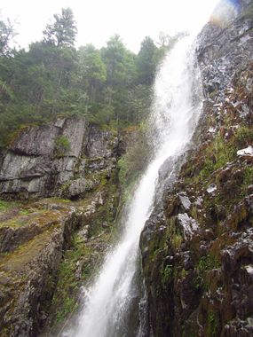
R6-R9 is collectively known as Elkhorn Mountain Falls and is well over 200ft. The drop is multi-tier and is broken up into several rappels.
- R6: 50ft from tree DCR. Land on downwards sloping platform. Use caution moving over to a large fir tree DCR. (Rappelling DCL may be the way to go if you want to run R7 completely in the flow. Once you start down the right side of the falls it is difficult to get back over to the other side.)
- R7: ~130ft from aforementioned fir tree down a wet gully out of the flow. Landing on a large bench that runs across the face of the falls.
- R8: Cross the bench and watercourse to DCL side of the falls to a fixed anchor on a tree. 70ft on overhung rappel. Awkward landing in a tree.
- R9: Rappel from mostly-dead cedar tree 20ft into the watercourse and then 25ft down to the bottom (~50ft total).
Continue downstream. Pass through talus field with some large shifting blocks.
- R10: 45ft. Tree DCL. If rappeling out of the flow, beware inviting ledge that leads you to continue to move DCL... if you follow, you risk a pendulum back into the falls.
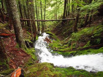
Continue downstream through some mossy cataracts. All can be downclimbed on one side or the other.
- R11: 40ft photogenic rappel. Tree DCL.
Exit[edit]
Continue downstream another 10min to reach the confluence where another tributary enters DCR. Five minutes later, exit DCR by scrambling up a steep bank. As soon as you're atop the ridge, the terrain mellows out. Do a descending traverse, downhill and eastwards to meet the trail running along the south side of the Little Santiam River in a few minuts. Follow the trail 1.4mi back to your car a the lower trailhead. En route you will pass the famous Three Pools area with some interesting rock formations. Hike out takes about 35min.
Red tape[edit]
None.
Beta sites[edit]
Trip reports and media[edit]
 Karl Helser's NW Adventures : Elkhorn Canyoneer 5-6-17
Background[edit]
Creek was first descended by Karl Helser, Keith Campbell, Kevin Clark, Kaitlin Rupert, Wim Aarts, and Rebecca Silverman.

