Emerald Creek (Colorado)
| Rating: | |||||||||||||||||||||||||||||||
|---|---|---|---|---|---|---|---|---|---|---|---|---|---|---|---|---|---|---|---|---|---|---|---|---|---|---|---|---|---|---|---|
| | Raps:2-3, max ↨105ft
Red Tape:No permit required Shuttle:None Vehicle:Passenger Rock type:Limestone | ||||||||||||||||||||||||||||||
| Location: | |||||||||||||||||||||||||||||||
| Condition Reports: | |||||||||||||||||||||||||||||||
| Best season: | Aug-Sep
|
||||||||||||||||||||||||||||||
| Regions: | |||||||||||||||||||||||||||||||
Introduction[edit]
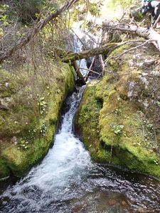
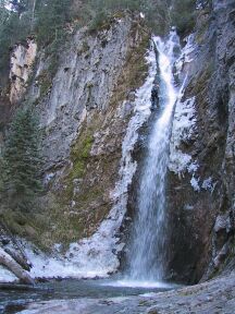
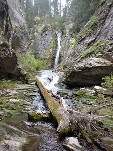
Emerald Creek is a short limestone drainage, of which there only a few in Colorado. This beautiful, mossy canyon is a good introductory canyon. The trail passes by Spring Cave and only a short section of forest scrambling is required before descending dirt gully to reach the creek above the waterfall. The canyon has 2-3 rappels in a unique lush environment with a few potholes and finishes with a short bushwhack through the forest.
Take special care to preserve this spot - do not damage the rock, moss or vegetation, and be careful to avoid erosion.
Spring Cave
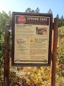
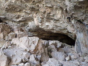
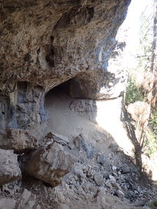
Canyoners will pass Spring Cave on the short trail. Spring Cave is open April 16-August 14. If exploring underground in Spring Cave, obtain a permit from the Forest service and follow decontamination procedures for White-Nose Syndrome, which can affect the bat population.
Hunting
During hunting season, wear bright clothing as this area is frequented by hunters.
Approach[edit]
Driving from Meeker, CO follow Highway 13 East out of town for a mile or so and turn right onto County Road 8 for another 18 miles to the town of Buford. Turn right onto County Road 10 crossing the White River. When the pavement ends, turn left on the dirt road and follow it at the next turn to the right and continue 10 miles to the South Fork Campground at the end of the road.
Park at the South Fork Trailhead in the day use area at the south side of the South Fork Campground.
Hike the South Fork Trail to the south and follow signs to Spring Cave taking the first fork to the right over the bridge spanning the South Fork of the White River. Hike uphill on a long switchback. After the switchback and below the top of the ridge, pass and a grove of trees to reach the mouth of Spring Cave.
Pass the cave entrance and climb limestone benches on the opposite side of the cave. Follow a trail heading east and up to the top of the limestone ridge. Crest the ridge in a meadow area, where the canyon becomes visible to the east. Emerald Creek drains the catchment including Cliff Lakes high above.
Hike in the meadow uphill parallel to the canyon near the rim and look for a reported limestone arch and try to glimpse the waterfall up canyon. Keep hiking along the rim through the meadow and bushwhack a short distance through the forest. Drop into the canyon down a loose dirt gully upstream from the waterfall.
Descent[edit]
Emerald Creek is slippery.
A short cascade into a pothole precedes R1.
R1: 105' from a tree on Canyon Right. The waterfall ends in a chest deep pool.
R2: 25' releasable to negotiate a slippery series of steps. Staying in the watercourse will prevent erosion.
R3: 35' from a tree on Canyon Left choosing a line that avoids foot entrapment between large boulders while on rope
A fun short elevator into a deep pothole
Exit[edit]
Either continue downstream in or next to Emerald Creek through bushes and fallen logs to the South Fork of the White River, cross the river and follow the South Fork Trail back to the parking location or head cross country straight north through the forest to the approach trail and bridge.
Red tape[edit]
Beta sites[edit]
Spring Cave: https://www.uncovercolorado.com/landmarks/spring-cave/
Trip reports and media[edit]
early 2000's: first explored by Michael Dallin
Sept2021: Ira Lewis, Andrew Tanasescu and Kati Wright - beta update, kml added, new photos & explored nearby Cave Creek to the north and the next drainage to the south without finding anything else worth visiting.

