Enigma Canyon
| Rating: | |||||||||||||||||||||||||||||||
|---|---|---|---|---|---|---|---|---|---|---|---|---|---|---|---|---|---|---|---|---|---|---|---|---|---|---|---|---|---|---|---|
| | Difficulty:3A III (v3a1 III) Raps:max ↨60ft
Red Tape: Shuttle: Vehicle:4WD - High Clearance | ||||||||||||||||||||||||||||||
| Location: | |||||||||||||||||||||||||||||||
| Condition Reports: | 4 Apr 2021
"A friend and I wanted to explore this remote area of the Swell and we saw on RopeWiki that there was a seldom-visited canyon named Enigma near by. Th |
||||||||||||||||||||||||||||||
| Best season: | Spring; Fall
|
||||||||||||||||||||||||||||||
| Regions: | |||||||||||||||||||||||||||||||
Introduction[edit]
Approach[edit]
From the trailhead it is a short half mile jaunt due south across open desert and brush towards the Enigma Canyon drainage. There are likely many spots to drop into the drainage so you just need to find a way down. The drainage is just a little draw to the east so if you find you are at a rim and cannot easily drop in, just make your way eastward as the cliff bands give way to flatter terrain and then drop in.
Once in the Enigma drainage follow it down canyon as it heads southwest. It is a bit of a hike-a-canyon for a while until you encounter your first obstacles.
ALTERNATE WEST RIM APPROACH
It is possible to start this canyon for the West Rim of the Muddy Creek by following a faint ranchers trail to a weakness in the cliff band (denoted by two very large carins as of 2021) and then cross the Muddy Creek and head up Poncho Wash to the "ramp" that accesses the mesa. This effectively turns the exit for the canyon into the approach (see exit description below).
Having done this alternate approach I would say it really isn't all that worth it.
Descent[edit]
The canyon is very infrequently descended, so if you choose to descend this canyon, expect there to be loose rocks, accumulated sand, and debris on the drops and holds as there is so little traffic that would normally clear out some of that accumulated detritus.
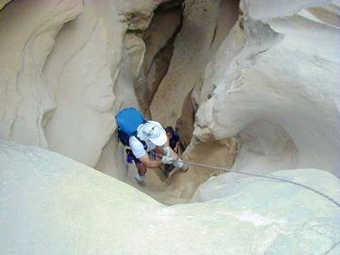
The first few drops are down-climbable, but you wouldn't be able to easily determine that--or see your footing--from the top. That, combined with the loose rock, sand, debris, and the potential for holds to crumble mean that it is probably a good idea to set up a rappel or a handline.
Most raps are short and can be anchored from trees or rocks. It is possible to fiddlestick some drops to minimized gear placement and anchor building, but check the pull because brush, edges, and other things might make the release difficult or cause the pull cord or rope to snag and get stuck. The last drop is the largest. WE didn't measure it out, but a 200 foot rope which is sufficient. The drop is probably less than 100 ft.
Exit[edit]
Enigma canyon will eventually open into the larger (wider) Muddy Creek canyon. At this point hike upstream a little ways looking for a narrow side canyon on the East (up canyon right) with a wash emanating from it. This is the bottom of Poncho Wash and the start of the Enigma Exit.
Hike up Poncho Wash for 0.3 miles while keeping a close eye out to the right. After hiking up Poncho, you will notice a ramp on both the right and left sides of the canyon. This is caused by a fault line. The left (north) ramp dead ends on a high cliff above Muddy Creek. The right (south) ramp is the one you want. These ramps are just before a big bend in Poncho Wash (while heading up canyon).
Carefully make your way up the ramp. Loose rocks are a hazard throughout the ramp, so use caution. Only one place is exposed and it can be covered with slippery mud at times.
After climbing the ramp, veer right and scramble up to the top of the rim. There is a nice break in the cliffs making the rest of the route fairly easy. From here you need a map, compass, GPS will be best but in general you want to head northeast keeping between the Poncho Wash drainage on the north and rim walking the Enigma Canyon drainage on the south untill it subsides into a draw. At the point head due north back to the trailhead.
Red tape[edit]
Beta sites[edit]
 Super Amazing Map : Enigma Canyon
 CanyonCollective.com : Enigma Canyon
 SummitPost.org : Enigma Canyon
