Epinephrine Error
| Rating: | ||||||||||||||||
|---|---|---|---|---|---|---|---|---|---|---|---|---|---|---|---|---|
| | Difficulty:3A III (v3a1 III) Raps:20, max ↨125ft
Red Tape:No permit required Shuttle:None Vehicle:High Clearance Rock type:Sandstone | |||||||||||||||
| Location: | ||||||||||||||||
| Condition Reports: | 7 Sep 2025
"This was the 7th time Ive run this canyon and this time with a group of 7. We completed it, car to car, in 6.5 hours. With a little TLC (clean up of |
|||||||||||||||
| Best season: | ||||||||||||||||
| Regions: | ||||||||||||||||
Introduction[edit]
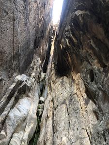
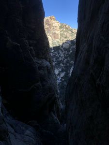
This canyon is a deep and narrow chimney system between the Epinephrine Summit and Black Velvet Peak. It has been used by rock climbers that make a major navigation error getting off the mega-classic 1600 foot tall 5.9 rock climb Epinephrine, and go down this gully, instead of using the walk-off. Since those climbers often hit this gully as it's getting dark, this can be a serious all night EPIC getting down the 20 rappels to Black Velvet creek. However, from a well trained and well prepared canyoneer's perspective, it can be a really fun day out. It's very well shaded, so it should be good for summer months. Take this canyon seriously. Do not attempt if you are not a trained canyoneer.
Approach[edit]
- Non-Shuttle
Park at Black Velvet parking area 36.03438, -115.44930. Hike the climbing approach trail staring at 36.03484, -115.45296, veer off toward the Frogland approach trail at 36.03599, -115.45936, climb up the Frogland approach trail to 36.03428, -115.46124. Traverse South to 36.03291, -115.46096 and climb the Frogland exit gully to the saddle at 36.03360, -115.46315 Take a hard left up the slabs (follow the cairns), continue on more obvious trail to the ridge top at 36.03168, -115.46551. Go North West on the ridge top to the East side of Black Velvet Peak 36.03351, -115.46966, and down slightly to the saddle 36.03427, -115.46940 between Black Velvet Peak and Epinephrine Summit. This approach has some minor exposure and does take a few climbing moves here and there. NOTE: It is not recommended to run this canyon when the winds are high. It can feel very unsafe on the ridge with strong winds and this will increase your trip time significantly.
- Shuttle
Use the same approach as for Mud Springs, but travel further North on the ridge top trail to 36.03547, -115.48349. Then descend the ridge to 36.03327, -115.47611 and work your way along the rocky ridge line to Black Velvet Peak. Then descend to the saddle at 36.03427, -115.46940.
Descent[edit]
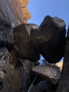
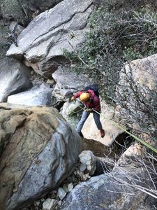
Follow the obvious sandy gully to the East descending quickly to the first rappel. Each anchor typically has multiple slings, cords, you name it, some only 2, some more like 20! At one specific rappel, you will notice 2 large chock-stones double stacked bridging the narrow canyon with an anchor around these stones. It is highly advised that the last person use this anchor, otherwise it's very likely your rope will get stuck on multiple other chock-stones below this double stacked set. This canyon carries the potential to get your rope stuck on most of the rappels. Using a fiddle stick or just double stranding, at least for the last person descending, is highly recommended. Make sure you bring enough rope and have the skills to prevent / mitigate this.
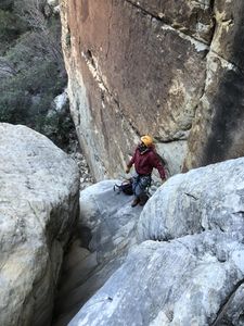
Near the bottom of the narrow canyon, where it widens up, you can bypass one rappel using a 4th class climb-around DCL. Below that is a rabbit hole with a hand sling that allow you to bypass a final rappel out of the narrow canyon. After the rabbit hole is one more rappel off a tree to get into the West Frogland Gully. This gully is mostly down-climbing with one spot that has various rappel stations.
Following the water course (DCL) you will get to the final rappels that take you first down a trough. NOTE: It is easy to get your gullies mixed up. You want the one on the left, not the one on the right. There are some cairns in the gully on the right that could confuse canyoneers descending. These are likely for rock climbers who are climbing up and out. If you find yourself here, head back up and find the gully to the left of it. Using the GPX with satellite view is very helpful.
The first of the "last rappels" is anchored on a tree DCL up high on the trough. Some canyoneers start here, then make a hard right over a face and then down to the Black Velvet Creek level. You will use a lot of rope doing this.
Alternative: After rappelling over the edge of the trough, there is an anchor high on the right (HCR), just over the edge, off a small tree. There is a big rock you will need to wedge yourself behind that you can only get to by rappelling, then traversing over to mid-rappel. If you choose this approach, note that only a couple people at a time can fit (crouch) at this station and it is difficult to get to. Send someone first who can use a combination of climbing, stemming and rappelling to traverse to the station, then assist others over. Make sure you know how to ascend if this is your plan as you could easily rappel past this anchor. Make sure you establish clear communication and coordination if you choose this anchor.
The "last rappels" can be very hard to find in the dark. Start this canyon early. Make sure to get out while there is still daylight.
Advice:
- Make sure your group is fit and well equipped. This means: more than enough rope, ascending gear, headlamps with spare batteries, warm clothes, and maybe some space blankets and tea lights should you find yourself in a pickle. Whistles might also come in handy should the wind get too loud to communicate verbally. Also, bring a rescue beacon.
- Start very early. It will likely take you longer than anticipated. Better yet, do it first with someone who has done it before.
- Don't bring a large group. Stick with a small team. Efficiency is important with this one.
- Be prepared to get your feet wet towards the end. The water is cold. Do the canyon on a warm day.
Exit[edit]
From the bottom of the last rappel, follow the water course through the brush to the open main Black Velvet Creek, down the creek past some house sized boulders, then follow the climber's trail DCR on very dark red stone up and out of the creek bed. You will soon be back on the main trail back to the parking lot.
Red tape[edit]
Beta sites[edit]
Trip reports and media[edit]
Our 8th March 2020 trip:


