First Water Canyon
| Rating: | |||||||||||||||||||||||||||||||
|---|---|---|---|---|---|---|---|---|---|---|---|---|---|---|---|---|---|---|---|---|---|---|---|---|---|---|---|---|---|---|---|
| | Difficulty:3A I (v3a1 I) Raps:1, max ↨100ft
Red Tape:No permit required Shuttle: Vehicle:Passenger | ||||||||||||||||||||||||||||||
| Location: | |||||||||||||||||||||||||||||||
| Condition Reports: | 17 Mar 2024
"Water seeping through the canyon. A little canyon with some character. A large owl flew right over us by the anchor station. |
||||||||||||||||||||||||||||||
| Best season: | spring summer fall
|
||||||||||||||||||||||||||||||
| Regions: | |||||||||||||||||||||||||||||||
Introduction[edit]
A short canyon often linked up with other routes in the area.
From Phoenix, drive east on US60 through Superior and Miami, turning left onto SR188, then right onto SR288. After driving on SR288 for 15.8 miles turn left onto an unsigned dirt road or park on the side of the road here if driving a passenger car. You can either start the approach hike here or from the dirt road and parking area just south of the canyon. The mileage is about the same either way - i.e., short.
Approach[edit]
From the parking area for Hog Canyon, hike southeast along SR 288, then in the open upper drainage of the canyon once it becomes apparent for approximately 0.3 miles.
Or, from the First Water turnoff (33.73914, -110.96091), hike northwest a very short distance to the drainage and downclimb in.
Descent[edit]
Easy downclimbs land you at the one rappel.
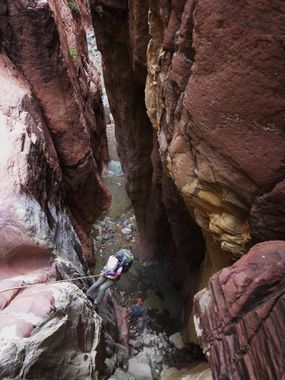
R1: 100' into narrow slot from a bolted anchor.
Continue down canyon a short distance until it opens and begin looking on your left for a way up the steep slope for the exit.
Exit[edit]
Once the slope on canyon left looks climbable, simply head up when you begin to see signs of travel from those that came before you. There is a faint trail to follow that you may find and lose a few times along the way. The route is quite steep with sections of brush and loose rocks, but at least it isn't all that long. Head up the slope to the southeast to find a point where an easy scramble through a break in the cliff above will grant access up to another slope that leads in short order to a dirt road and a few nice campsites. Follow this road northeast back to SR 288 / to your vehicle.
Red tape[edit]
Beta sites[edit]
 Super Amazing Map : First Water Canyon
