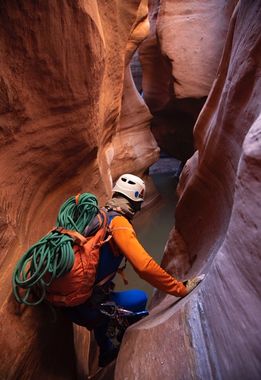
Fry Canyon (Cedar Mesa)
| Rating: | |||||||||||||||||||||||||||||||
|---|---|---|---|---|---|---|---|---|---|---|---|---|---|---|---|---|---|---|---|---|---|---|---|---|---|---|---|---|---|---|---|
| | Difficulty:3B II (v3a2 II) Raps:1, max ↨50ft
Red Tape:No permit required Shuttle:None Vehicle:Passenger Rock type:Sandstone | ||||||||||||||||||||||||||||||
| Location: | |||||||||||||||||||||||||||||||
| Condition Reports: | 27 May 2020
"Cold swimmer but the sun warmed us up fast. Pretty but very short narrows. The trip down to the ruins from the top (just off the exit route) is fun an |
||||||||||||||||||||||||||||||
| Best season: | Spring through fall
|
||||||||||||||||||||||||||||||
| Regions: | |||||||||||||||||||||||||||||||
Introduction[edit]
The technical section of this route is 100 feet long and consists of the entry rappel (50ft) followed immediately by a 10ft downclimb into a 30ft swim. 50 feet after this the canyon opens. The hiking portion is 2 hours spent about equally 1 hour for the approach and 1 hour for the exit. The "upper narrows" is 100 feet long and contains one pool to wade through and then a walk through corridor. This takes about 5 minutes. The cliff dwellings are a site to see, but they are accessed from the rim, not from below in the canyon. From down in the canyon there is only a brief glimpse just after the exit form the swim. For the technical canyoneer, there is practically nothing to note.
Approach[edit]
Descent[edit]
15 minutes for 1 rappel, a 10 foot downclimb and a 30 foot swim.
Exit[edit]
A well worn path and cairns mark the way. If you find yourself attempting a Class IV move then there is an easier way.
Red tape[edit]
Beta sites[edit]
 Chris Brennen's Adventure Hikes (Southwest) : Fry Canyon
 RoadTripRyan.com : Fry Canyon
 Climb-Utah.com : Fry Canyon
 RoadTripRyan.com : Fry Canyon Ruins Overlook
 HikeArizona.com : Fry Canyon - Monticello
 ToddsHikingGuide.com : Fry Canyon
 Super Amazing Map : Fry Canyon Slot
 AmericanSouthwest.net : Fry Canyon
 CanyoneeringUSA.com : Fry Canyon
Trip reports and media[edit]
 Candition.com : Fry
