Gorge Creek Canyon
| Rating: | |||||||||||||||||||||||||||||||
|---|---|---|---|---|---|---|---|---|---|---|---|---|---|---|---|---|---|---|---|---|---|---|---|---|---|---|---|---|---|---|---|
|
| |||||||||||||||||||||||||||||||
| | Raps:5-6, max ↨200ft
Red Tape:No permit required Shuttle:None Vehicle:Passenger Rock type:Granite | ||||||||||||||||||||||||||||||
| Start: | |||||||||||||||||||||||||||||||
| Parking: | |||||||||||||||||||||||||||||||
| Condition Reports: | |||||||||||||||||||||||||||||||
| Best season: | Jul-Sep
|
||||||||||||||||||||||||||||||
| Regions: | |||||||||||||||||||||||||||||||


Introduction
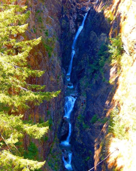
The best checkpoint for water flow is from the Gorge bridge that overlooks the canyon, from here one can see all the rappels except R1. Despite appearances from the bridge, all of the falls spread out immediately after pouring over and are relatively benign while on rappel. R5 is the burliest looking from the anchor, but the rappeller does a quick duck under to cross the flow at the top and is behind the falls to the bottom. All of the falls may look intimidating from the bridge because one is looking at them from the side. The waterfalls pour over to canyon right and spread out, making them easier than one would imagine from the bridge.
Gorge Lake Campground is a nice campground with toilets and fire pits, just before the hamlet of Diablo, east of Gorge Creek.
Approach
Since wildfires burnt through the area the approach trail is hard to find. From the east side of the bridge pick your way up the slope, inevitably finding yourself in a mess of burnt-down trees. Keep going until 1500ft elevation, and then side-hill left to eventually join the watercourse close to R1.
At this point the flow is roughly 1/2 of that in the ensuing rappels below the confluence of the two upper forks.
Other Approaches
It may be possible to start the canyon much higher than stated in the beta by using the trails climbers use to access David Peak (Little Davie). For more information see:
- http://www.stephabegg.com/home/tripreports/washington/northcascades/davie
- http://www.summitpost.org/davis-peak/257251
Descent
- R1: DCR, 115ft. Unlinked anchors.
Short creek walk, with 8ft jump from boulder.
- R2: DCR, 150ft. Unlinked anchors.
Bridge comes into view, start of the slot section.
- R3: DCR from smashed-up webbing-linked anchors, two options:
In the water course:
Initially 150ft down into free-hanging crack, then across floor to next drop. The original R4 is DCL above the boulder wedged across the gap in front of you, however sometime since the original beta was written a blockage has collapsed making it inaccessible (except perhaps via the high-flow traverse line - untested). Until a replacement R4 is established here, drop another 50ft through the new rabbit hole, into the cavern below. The pull is actually OK from the cavern, as there's a direct line through the hole to the bolts far above, and with rapid pulling there's not much to catch the rope as it falls.
Via the high-water traverse line:
There's a line of bolts DCR which provides a high-water route to avoid dropping into the crack. These have been unused for an unknown number of years and shouldn't be relied upon.
- R5: DCL, 75ft. Single anchor.
In the 2006 topo there's mention of a high-water bypass here too, seemingly following a ledge DCL. It's unclear if there still a bolt at the end, or if it's a jump. This photo shows people on the ledge.
- R6: down-climb DCR crack, 25ft.
A bunch of smaller down-climbs takes you to underneath the bridge, and eventually to the lake.
Exit
Enter the lake and swim about 500 feet to an easy scramble out on the left just past the corner. Hike up the nose of the ridge to the road.
There's allegedly a trail leading from a short green railing on top of the cliff at the corner you just swam past (source).
Red tape
Beta sites
 CanyoneeringNorthwest.com (archive.org) : Gorge Creek
- Super Amazing Map : Gorge Creek Canyon
Trip reports and media
- Pictures from 2007
- Facebook Album - July 2015
- 2006 topo - outdated, don't use!
