Grant Creek Canyon
| Rating: | |||||||||||||||||||||||||||||||
|---|---|---|---|---|---|---|---|---|---|---|---|---|---|---|---|---|---|---|---|---|---|---|---|---|---|---|---|---|---|---|---|
| | Raps:5-7, max ↨200ft
Red Tape:No permit required Shuttle:None Vehicle:Passenger | ||||||||||||||||||||||||||||||
| Location: | |||||||||||||||||||||||||||||||
| Condition Reports: | 21 Sep 2019
"No old webbing or anchors at any of the rappels. Setup all new bomber anchors. Water flow was amazing. Last water fall was incredible and beautiful |
||||||||||||||||||||||||||||||
| Best season: | Late Summer to Early Autumn;BEST in Aug;Sep
|
||||||||||||||||||||||||||||||
| Regions: | |||||||||||||||||||||||||||||||
Introduction[edit]
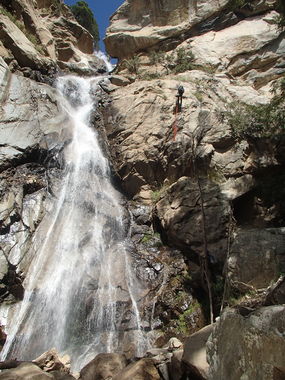
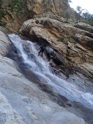
A fun canyon with a few mellow waterfall rappels and spicy downclimbs throughout the upper canyon and ending with an incredible beautiful big waterfall rappel.
Approach[edit]
From Cunningham TH follow main road south east. Shortly there will be a small road heading south, follow road. After a few hundred feet leave road heading east downhill into minor drainage. Follow minor drainage a few hundred feet into Grant Creek.
Descent[edit]
Follow drainage.
Bypass first major falls downclimbing LDC. Handline down everyone and then partner assist last person down.
R1: 50' off of tree LCD crossing water flow.
Not too far down stream will come to R2.
R2: 60' off of tree RDC into water flow.
R3: 30' or bypass falls downclimbing tree RDC.
R4: 50' or bypass falls with partner assist downclimbing loose dirt/rock LCD.
R5: 30' down boulder directly into water flow anchoring off of boulder or bypass falls downclimbing loose rock LCD.
After much bouldering and downclimbing come to the big falls.
Very little options for anchoring to go down immediate water flow. At very top of falls to the bottom is right at about 200', if anchoring back from falls come prepared with lots of webbing or do a multi-stage rappel LDC as described below.
R6: 150' off of tree above waterfall LCD to ledge LDC. Ledge is big enough for about 4-5 people with a couple good tree options for next stage. This will get you in the flow a little.
R7: 80' off of tree LDC on ledge. This will not be in the flow at all.
Exit[edit]
After last rappel at big falls, continue to follow Grant Creek through boulders. As soon as north side (RDC) starts to flatten out a little, leave creek to cut across to Post Creek. Boulder hop up Post Creek about half a mile. At first major intersection with minor creek coming in on LUC, leave Post Creek going right (east). There is a faint trail, but best to head up directly taking least bushy route. After a little over a mile gaining about 1800' of elevation, remainder of route will flatten out. Continue north staying on ridge top for about half a mile. Then head right (east) downhill a short distance then uphill to road. Follow road back to Cunningham TH.
Red tape[edit]
Beta sites[edit]
 Super Amazing Map : Grant Creek Canyon
 HikeArizona.com : Grant Creek Canyon
 Arizona Technical Canyoneering Book by Todd Martin : Grant Creek Canyon
 ToddsHikingGuide.com : Grant Creek Trail; Pinaleno Mountains

