HP South (West Fork)
| Rating: | |||||||||||||||||||||||||||||||
|---|---|---|---|---|---|---|---|---|---|---|---|---|---|---|---|---|---|---|---|---|---|---|---|---|---|---|---|---|---|---|---|
| | Difficulty:3A III (v3a1 III) Raps:6-8, max ↨300ft
Red Tape:No permit required Shuttle:Required 45 min Vehicle:High Clearance Rock type:Sandstone | ||||||||||||||||||||||||||||||
| Start: | |||||||||||||||||||||||||||||||
| Parking: | |||||||||||||||||||||||||||||||
| Shuttle: | |||||||||||||||||||||||||||||||
| Condition Reports: | 28 Jun 2025
"For the approach, stay high LDC until the head of the canyon to avoid blackberry and Locus bush. For R1, High LDC rig will work, or figure it out. For |
||||||||||||||||||||||||||||||
| Best season: | Spring, Summer, Fall
|
||||||||||||||||||||||||||||||
| Regions: | |||||||||||||||||||||||||||||||
Introduction[edit]
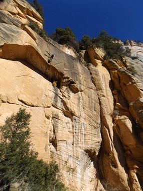
A rugged West Fork of Oak Creek canyon. Fairly brushy approach, but quick to first rappel. Rappels come one right after the other. Featuring a good big wall rappel and excellent views. Canyon drops several feet next to West Fork trail. Easy and scenic exit out.
Possible to do as passenger vehicle shuttle. About a 5 minute shuttle, with a steep ridge hike, about 1400ft elevation gain.
Possible also to do as high clearance vehicle shuttle (4x4 when roads are wet). About 45min shuttle, no additional hiking, no elevation gain.
Canyon is named after Harding Point from which the canyon start from and drops directly south of.
Approach[edit]
Drop your shuttle and drive north to park at the first switchback heading up out of Oak Creek Canyon and start your hike from there following the track.
Quite brushy headed down to first rappel. Stay on the left side of drainage (i.e keep drainage on your right) and traverse out on sloped side. Eventually find light trail to first rappel.
Descent[edit]
R1: 150' off LDC high tree or dead tree trunk RDC.
R2: 40' off rock pinch or tree down awkward notch, followed by a downclimb RDC. Could stay on rope about 80' to second stage, but rope-stick potential.
R3: 30' off tree RDC.
R4: 20' off tree LDC or possible downclimb.
R5: 325' tree center of watercourse for a clean rap and pull - or - 300' off tree LDC. May want to handline to anchor, as slopes and is slippery. Edge is not really sharp, rope protection not an issue, but may still want to reset rope every so often. Rappel starts with 15' drop to sloped ledge, then drops 200' with free hang about 100' to another sloped ledge. Continue down next free hang section to walled landing.
R6: 80' off of tree LDC. Crack in watercourse has rope-eating potential.
Longer section of hiking and downclimbing. Fairly pleasant, with minimal brush.
R7: 25' off tree. Lands footsteps away from West Fork of Oak Creek trail where we experienced curious onlookers wondering what we were doing.
Exit[edit]
2.5 miles to 89A at Oak Creek and your shuttle.
Red tape[edit]
West Fork of Oak Creek trailhead for Exit vehicle is often crowded and parking limited. $11 per day. Call of the Canyon Picnic Site. Optionally, can find parking about half mile north up the road off the highway.
Beta sites[edit]
Trip reports and media[edit]
https://www.facebook.com/media/set/?set=a.4061160743904335&type=3
Background[edit]
First descent by Jay Wisocki
