Hager Canyon
| Rating: | |||||||||||||||||||||||||||||||
|---|---|---|---|---|---|---|---|---|---|---|---|---|---|---|---|---|---|---|---|---|---|---|---|---|---|---|---|---|---|---|---|
| | Raps:14-15 raps + 9 slides, max ↨80ft
Red Tape:No permit required Shuttle:Optional 5min Vehicle:Passenger | ||||||||||||||||||||||||||||||
| Start: | |||||||||||||||||||||||||||||||
| Parking: | |||||||||||||||||||||||||||||||
| Shuttle: | |||||||||||||||||||||||||||||||
| Condition Reports: | |||||||||||||||||||||||||||||||
| Best season: | July-Sep
|
||||||||||||||||||||||||||||||
| Regions: | |||||||||||||||||||||||||||||||
Introduction[edit]
In this canyon resides a troll named Hager. We can't wait for you to meet him. Most of the time he's a jolly and mischievous fellow that likes to dunk you into pools and tug at your feet. Be wary of his dark side though, he is a troll after all.
Hager Canyon, aka Sick Puppy canyon is a great canyon in the Gifford Pinchot National Forest near Packwood, WA. This canyon is a waterpark filled with slides, jumps, and beautiful scenery. However, groups should not underestimate the hydraulic hazards in this canyon and the technical ropework needed to complete the lower section. Special challenges include rigging retrievable traverse lines (with intermediate points), recirculating hydraulics that can be difficult to escape from if trapped, and rappels that require careful and confident footwork/balance. The canyon has highly carved features despite not being a very deep canyon, and the number of slides in the creek is very impressive. The canyon transitions from a water park in the upper and middle sections to technical ropework in the bottom section. All canyoneers running this canyon should be confident swimmers. Use low-impact canyon travel by staying in the watercourse, below the flood line.
Driving Directions: From Highway 12, turn onto NF-48 (46.58867, -121.68681) to access the canyon. This road is across the street from the Crest Trail Lodge and is easy to miss. (Google Maps lies and may try to route you via NF-21 further south which does not actually connect to NF-48.) Drive up NF-48 for 2.8mi and park at the second switchback (46.58631, -121.65515). If you are planning to take the lower exit, drop a shuttle car at the first switchback (46.58969, -121.66427).
Drainage area: 4.22mi^2. Highest elevation point for the drainage is around ~5000 ft. Given the volume of water that pumps through year-round, it's highly likely Hager is spring-fed.
Waterflow: The gauge (USGS:14231900 Cispus River AB Yellowjacket Creek) will give a good projection of waterflow during normal season (July - October). However, during summer when heavy snow melt is occurring, it can be unreliable due to its smaller catchment and lower snow amounts compared to other gauged rivers nearby. Hager seems to be run comfortably by most groups by the beginning of August. A number of springs in the upper drainage maintain good water well into the season.
"Upper Upper Section": The section of creek between Hager Lake and the main canyon was run in 2021. While scenic, it does not have the same beauty and fun factor as the lower canyon, though it does include a beautiful 80' vertical rappel.
Approach[edit]
From the parking area, head uphill into the forest and skirt the edge of the creek for several hundred feet along an obvious use trail. At about 2100' elevation, continue following the use trail and drop into the creek at S1 (46.58514, -121.65250).
Descent[edit]
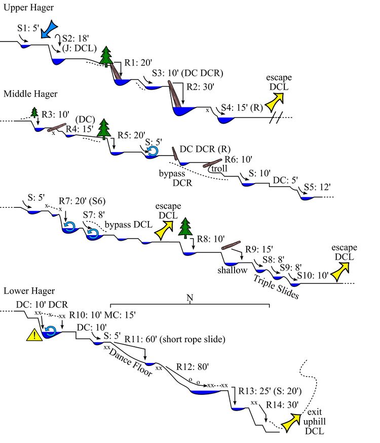
DCL = down canyon left; DCR = down canyon right; S = slide; DC = down climb
Upper Section[edit]
S1: 5' (just above S2)
S2: 18' into a large pool. It is also possible to jump DCL from a ledge into the pool. In higher flow, this is a counter-clockwise recirculating hydraulic. It is possible to down climb/rappel from a tree on DCL to check depth and station someone at the bottom for assistance out of the pool.
R1: 20' DCR from webbing around a tree into the pothole below. As of May 2024 there is a large cedar in the pothole.
S3: 10' low angle slide just after R1. This is down-climbable DCR.
There is a 15' swim to the next anchor.
R2: 30' DCL from webbing around a log.
S4: 15' low angle bumpy slide or rappel DCR from a single bolt.
There is a nice open area after S4, with an easy escape point back to the vehicles if necessary.
Middle Section[edit]
R3: 10' DCL from webbing around a tree. There is a ledge DCL to get to the anchor. Note that there is a log in this pool.
R4: 15' DCR from single bolt. This drop can also be down climbed.
R5: 20' DCR from webbing around a tree.
R6: 10’ from webbing around a log close to the center of the creek. Look for a log cave underneath the large log. Pretend you're a troll and demand a toll for continuing the canyon.
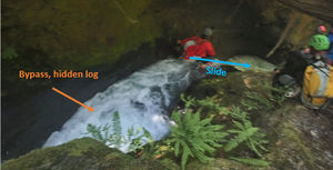
S5: This is a two-tier drop. Avoid the first tier as there's a hidden log in the pool. Instead, downclimb to the top of the second tier from DCR (see photo for reference). The second tier is a 12' slide. The slide terminates into a small pool and the canyon makes a sharp right turn.
S6/R7: 8' short slide into a shallow pool that leads directly to a steep 20' slide. To check pool depth or bypass the slide, there is a 10' traverse to a 20' rappel from a single bolt DCL.
The hydraulic at the bottom of the 20' slide can be tricky - be sure to station someone at the edge with a throw bag as needed. In higher flow, there is a risk of being swept over the next tier (S7), which is a slide but could contain hazards early in the season. It is best to send your strongest swimmer first. Pack management is also important here to avoid getting them stuck in the hydraulic, or getting swept over the next tier.
S7: 8' slide immediately after S6. In higher flow, this pool has a clock-wise recirculating hydraulic. This slide/pool can be bypassed DCL.
There are some small slides and down climbs after S7.
R8: Rappel 10' from a tree DCL. The single bolt anchor that was here has been removed. This drop can also be jumped from the ledge DCL slightly further away from the immediate bottom of the waterfall, however, the far wall extends out underwater so check first.
R9: 15' from tree DCL, or rappel from a single bolt from the boulder in the creekbed. The bottom of this pool is shallow and cannot be slid.
The next three drops are a fun series of back to back slides:
S8: 8' from the center of the pour over
S9: 8' from the center of the pour over
S10: 10'. Start your slide DCL.
Lower Section[edit]
The remaining section of the canyon is more technical than the upper, requiring multiple traverse lines and careful footwork to avoid fast moving flow and slippery rocks. It is possible to climb out of the canyon after S10 on DCL. After R11, the canyon channels into a deep narrow corridor with no escape options until below R14.
From the ledge DCR, downclimb into the lower pool, or use a single bolt DCR to handline or rappel down this slippery 15' slope. In high flow, the pool is knee deep and not too pushy even though it may look like it.
R10 + traverse line with intermediate point: DCL. The traverse is 15' and the rappel is 10'. Setup the traverse line using a team belay or self-belay method to get to the anchor station at the edge. The purpose of the traverse line is to avoid slipping into the chute, which funnels into a narrow and dangerous keeper hydraulic. Canyoneers have gotten trapped in this hydraulic, so extreme caution should be taken to avoid it, or to aid a stuck teammate. This drop has been done as a slide. If you intend to rappel or slide into the boil, a teammate should be positioned at the bottom to provide a rescue if a teammate becomes stuck.
The tier directly after R10 is very shallow. Downclimb DCR and slide 5' into a pool.
R11: AKA 'The Dance Floor'. 60' DCR from an unlinked bolts. The rappel is relatively low-angle, curves DCL, and requires careful footing/stemming over the swift moving water. The R12 bolt anchor is located DCR immediately at the end of the rappel where the canyon makes a sharp right turn. It is placed fairly high on the canyon wall. It is best for a strong climber and/or swimmer to go first. Hager, the troll, resides at the bottom of this rappel.
R12 + redirect: 80' DCR from a bolted Y-hang anchor. This rappel requires careful footing and balance on potentially slippery rock. Rappel 30' and step over the flow access the redirect/deviation on the DCL wall. The walls here have multiple hand holds to carefully reach the redirect. (Redirects are permanent anchors, please do not remove them.) Continue rappelling down the sloping rock edge away from the water. The rappel ends in an area where 3-4 people can stand and the single bolt for R13 traverse.
Traverse: From the single bolt DCL, rig a traverse line 15' to an unlinked bolted anchor DCL. The first person will may need to swim through the boiling pool and climb out to set the traverse line for the rest of the group.
R13: 15' DCL from unlinked bolts. Swim 20' through the final corridor. (In higher flow there is a risk of being swept over the final tier. It is best to send your strongest swimmer/climber first to climb out of the pool and assist teammates safely out of the pool.)
R14: 30' DCL from unlinked bolts. This rappel is out of the flow.
Exit[edit]
Non-shuttle Exit[edit]
Immediately after the last rappel, climb up the steep bank DCL using a series of roots and branches. From the top of the bank follow the obvious user trail that parallels Hager Creek back up to your starting point in about 15 minutes.
Shuttle Exit[edit]
After exiting the lower technical section, keep going downstream. Just ahead is:
R15: 50ft from log DCR down into a short slot-like section. (Too narrow at the bottom to be a good slide.)
Below R15, the creek opens up again. Look for a cairn atop a log DCL which marks an easy exit on a game trail up out of the drainage. This route out is a better long-term solution per combating erosion. The route out was well-marked in 2023. Once out of the drainage, contour left/west to pick up the obvious trail. Follow it downhill to a minor saddle at approx. 46.59072, -121.66043. From here, traverse west back over to the road through open forest. Hopefully, you left a shuttle car here. Exit takes ~10min.
Red tape[edit]
None.
Beta sites[edit]
Trip reports and media[edit]
Background[edit]
This canyon was first fully opened on June 26-27 by Ryan Ernst, Michael Peterson, Andrew Humphreys, Jake Huddleston, Barry Specht, Kevin Steffa, Haruka Lipscomb, and Tiffanie Lin. The canyon took multiple trips and attempts to complete the entirety of the main route due to early season high flows and hydraulic hazards. This canyon has been described as "cute and cuddly, with teeth" due to its very fun and seemingly innocuous nature. Just when you start getting comfortable, the teeth come out.


